
 |
2nd Light Forums |
 |
 |  |


|
Topic Title: Just let me know when the winds turn offshore.... Topic Summary: Hurricane Humberto Created On: 09/12/2019 03:44 PM |
Linear : Threading : Single : Branch |
|
 Topic Tools Topic Tools
|

 09/12/2019 03:44 PM 09/12/2019 03:44 PM


|
|
|
Potential Tropical Cyclone Nine Discussion Number 1
NWS National Hurricane Center Miami FL AL092019 500 PM EDT Thu Sep 12 2019 The disturbance in the southeastern Bahamas has not developed a closed circulation yet, but the cloud pattern is gradually becoming better organized. An Air Force plane is currently approaching the disturbance, and will give NHC more details on the structure of the system. Advisories are being initiated on this system as a Potential Tropical Cyclone to allow for the issuance of a tropical storm warning for a portion of the northwest Bahamas after consultation with the meteorological service of that country. The system is still under the influence of strong shear caused by an upper-level low in the Gulf of Mexico. As the disturbance moves away from the upper low, conditions are expected to be a little more conducive for development as indicated in the intensity forecast. With the exception of the GFS, which forecasts a vigorous trough crossing Florida into the Gulf of Mexico, the remainder of the global models develop a tropical cyclone near the northwestern Bahamas and move it as an intensifying system very close to the east coast of Florida. The NHC forecast opted for the solution of these latter models, however, it is emphasized that given the model discrepancy, both the track and intensity forecasts are highly uncertain, more than usual I would say. Key Messages: 1. The disturbance is expected to become a tropical storm and bring tropical storm force winds to portions of the northwest Bahamas within 36 hours. As a result, advisories have been initiated on Potential Tropical Cyclone Nine. Note that forecast uncertainty for these disturbances is generally larger than for tropical cyclones, especially beyond 48-72 hours. 2. The system is expected to bring tropical-storm-force winds and heavy rainfall to portions of the northwest Bahamas on Friday and Saturday. Significant storm surge is not expected in the northwest Bahamas from this system. Residents there should follow any advice given by local officials. 3. The system could bring tropical-storm-force winds and rainfall to portions of the Florida east coast over the weekend. Residents there should monitor the progress of this system. FORECAST POSITIONS AND MAX WINDS INIT 12/2100Z 23.7N 74.8W 25 KT 30 MPH...POTENTIAL TROP CYCLONE 12H 13/0600Z 24.5N 76.0W 25 KT 30 MPH 24H 13/1800Z 25.5N 77.2W 30 KT 35 MPH...TROPICAL CYCLONE 36H 14/0600Z 26.5N 78.9W 40 KT 45 MPH 48H 14/1800Z 27.5N 80.2W 45 KT 50 MPH 72H 15/1800Z 30.0N 82.0W 30 KT 35 MPH...INLAND 96H 16/1800Z 31.0N 82.0W 25 KT 30 MPH...INLAND 120H 17/1800Z 31.5N 80.0W 30 KT 35 MPH...OVER WATER Edited: 09/18/2019 at 05:02 AM by Central Floridave |
|
|
|
|
|
09/12/2019 04:16 PM
|
|
|
Such a deal. We might get more wind out of this one than Dorian. NHC
|
|
|
|
|
|
09/12/2019 04:54 PM
|
|
|
It should go offshore about the 12th of never
|
|
|
|
|
|
09/12/2019 05:02 PM
|
|
|
https://www.youtube.com/watch?v=nuGSRKMn4WQ
|
|
|
|
|
|
09/12/2019 07:55 PM
|
|
|
Tropical Tidbits, Greensleeves' link. Nice discussion.
|
|
|
|
|
|
09/13/2019 02:45 AM
|
|
|
Most of the 6z model runs (UK and ECMWF) keep it off the east coast. NHC 5AM update reflects this but their forecast is still to the left of the model consensus. Intensity forecasts are ticking up with the possible track staying over water.
------------------------- ... |
|
|
|
|
|
09/13/2019 03:59 AM
|
|
|
Offshore winds possible Sunday/Monday. You guys don't follow directions very well.
SUNDAY Tropical storm conditions possible. Southwest winds 40 to 45 knots with gusts to around 60 knots diminishing to 15 to 20 knots in the afternoon. Seas 12 feet subsiding to 6 feet in the afternoon. Extremely rough on the intracoastal waters. Showers likely and chance of thunderstorms. MONDAY West winds 10 to 15 knots. Seas 4 to 5 feet. A moderate chop on the intracoastal waters. Chance of showers and thunderstorms. |
|
|
|
|
|
09/13/2019 06:34 AM
|
|
|
12Z run of models (except for GFS) remind me of Dennis 1999.
------------------------- ... |
|
|
|
|
|
09/13/2019 08:02 AM
|
|
|
NHC 15Z forecast update reflects the 12Z model runs. Looks favorable so far.
------------------------- ... |
|
|
|
|
|
09/13/2019 08:17 AM
|
|
|
Friday nhc 11 o'clock update shows recurve and heading to Bermuda. Potential Cat 1 in 96 hours. Bring surf and offshore winds please. We need it.
|
|
|
|
|
|
09/13/2019 09:31 AM
|
|
|
------------------------- add a signature since I'm here in profile anyway |
|
|
|
|
|
09/13/2019 10:20 AM
|
|
|
the 12th of never. I hate that its true.
------------------------- "One of the reasons why propaganda tries to get you to hate government is because it's the one existing institution in which people can participate to some extent and constrain tyrannical unaccountable power." Noam Chomsky. |
|
|
|
|
|
09/13/2019 10:25 AM
|
|
|
me too johnny boy but we remain ever optimistic since we are florida "surfers"
should we wax up our big sticks so we can explore the green room? fool us once - shame on you fool us twice - hey we are florida surfers Edited: 09/13/2019 at 10:32 AM by Greensleeves |
|
|
|
|
|
09/13/2019 06:09 PM
|
|
|
8 pm Friday forecast path is even farther offshore and north of the Bahamas.
We're at the edge of the cone of uncertainty; tropical storm watch still in effect.
|
|
|
|
|
|
09/14/2019 08:03 AM
|
|
|
As of Saturday morning, things are beginning to look very interesting.
|
|
|
|
|
|
09/14/2019 08:10 AM
|
|
|
NWS showing due west wind all day SUNDAY and half the day on monday. Get on it tomorrow boys and girls!!!
------------------------- - |
|
|
|
|
|
09/14/2019 08:50 AM
|
|
|
------------------------- sneedeker |
|
|
|
|
|
09/14/2019 08:57 AM
|
|
|
Wed maybe noc so up in our grill ffs poles?
|
|
|
|
|
|
09/14/2019 09:06 AM
|
|
|
Why wait for offshores??? fun/challenging at some locations, Nice to surf with ya again Daner!!!....Pic of some local air droping into oblivion..great air drops today..
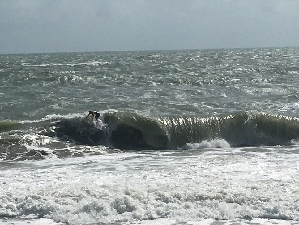
It was kinda thick out there...Icing the back now for round two later... Edited: 09/14/2019 at 09:17 AM by SurferMic |
|
|
|
|
|
09/14/2019 09:42 AM
|
|
|
Grievous
|
|
|
|
|
FORUMS
:
Surfing
:
Just let me know when the winds turn offshore....
|
Topic Tools |
FuseTalk Basic Edition - © 1999-2024 FuseTalk Inc. All rights reserved.