
 |
2nd Light Forums |
 |
 |  |


|
Topic Title: NEXT WEEKEND (oct 4th/5th) Topic Summary: yup, starting the hype machine Created On: 09/27/2014 07:00 PM |
Linear : Threading : Single : Branch |
|
 Topic Tools Topic Tools
|

 09/29/2014 08:19 AM 09/29/2014 08:19 AM


|
|
|
^^what he said. If you live beachside you can sneak in a quickie session and still keep plans with family. For a FL surfer it's all about proximity to waves. |
|
|
|
|
|
09/29/2014 09:05 AM
|
|
|
How is the hype shaping up? ------------------------- Replace turf grass with native plants that don't need irrigation and synthetic fertilizers or chemicals that can go into our waterways and ocean |
|
|
|
|
|
09/29/2014 05:01 PM
|
|
|
(I didn't mean to distract from the subject at hand with the disease we're all aware of. But if anyone caught the little poem in septembers ESM 'intercourse/ discourse' that pretty much somes it all up.. if not find one and read it, it'll do you good) ------------------------- 'Out of step' - Ian Mackaye |
|
|
|
|
|
09/29/2014 06:21 PM
|
|
|
I'll go out on a limb here and say that it could be 6' @ 10 sec average.
All models are in good agreement now that within 48 hours wind will be blowing with a good fetch. http://forecast.weather.gov/sh...?mz=anz905&syn=anz899 SEAS GIVEN AS SIGNIFICANT WAVE HEIGHT...WHICH IS THE AVERAGE HEIGHT OF THE HIGHEST 1/3 OF THE WAVES. INDIVIDUAL WAVES MAY BE MORE THAN TWICE THE SIGNIFICANT WAVE HEIGHT. ANZ899-300845- 506 PM EDT MON SEP 29 2014 .SYNOPSIS FOR MID ATLC WATERS...WEAK LOW PRES IS EXPECTED TO PASS E ACROSS THE FAR SRN WATERS TONIGHT INTO WED NIGHT. ANOTHER LOW NEAR BERMUDA WILL DRIFT N...TO JUST E OF THE NRN WATERS TUE NIGHT AND WED...BECOME NEARLY STATIONARY WED NIGHT INTO FRI...THEN MOVE OFF TO THE E FRI NIGHT. A COLD FRONT WILL MOVE E ACROSS THE WATERS SAT AND SAT NIGHT. $$ -------------------------------------------------------------------------------- SEAS GIVEN AS SIGNIFICANT WAVE HEIGHT...WHICH IS THE AVERAGE HEIGHT OF THE HIGHEST 1/3 OF THE WAVES. INDIVIDUAL WAVES MAY BE MORE THAN TWICE THE SIGNIFICANT WAVE HEIGHT. ANZ905-300845- EAST OF 69W TO THE HAGUE LINE BETWEEN 1000 FM AND 39N- 506 PM EDT MON SEP 29 2014 TONIGHT SE WINDS LESS THAN 10 KT BECOMING E. SEAS 2 TO 3 FT. TUE E TO NE WINDS INCREASING TO 15 TO 25 KT. SEAS 3 TO 4 FT. SHOWERS AND ISOLATED TSTMS. TUE NIGHT E TO NE WINDS 15 TO 25 KT. SEAS 4 TO 6 FT. SCATTERED SHOWERS AND CHANCE OF TSTMS. WED NE WINDS 15 TO 25 KT. SEAS 5 TO 9 FT. HIGHEST WINDS AND SEAS SE. WED NIGHT NE WINDS 15 TO 25 KT. SEAS 6 TO 11 FT. HIGHEST WINDS AND SEAS SE. THU THROUGH FRI N TO NE WINDS 20 TO 30 KT. SEAS 8 TO 14 FT. HIGHEST WINDS AND SEAS SE. FRI NIGHT W TO NW WINDS DIMINISHING TO 10 TO 20 KT. SEAS 6 TO 10 FT. SAT NW WINDS 10 TO 20 KT...BECOMING SW 5 TO 15 KT. SEAS 6 TO 9 FT. SAT NIGHT S WINDS INCREASING TO 15 TO 25 KT. SEAS 5 TO 8 FT. $$ |
|
|
|
|
|
09/29/2014 09:10 PM
|
|
|
Given that I am going back to work for a month away from here in sure y'all will have good waves half the time I'm gone at least. Still greatful to live here and get some waves finally. The last month I've put in more water time in 2 given days than several months in Texas. It is Florida but be greatful for where you live! Hope y'all score while I'm gone. See you in the water next month....p.s I'm still looking for a roomate. See my thread in the for sale section |
|
|
|
|
|
09/30/2014 06:21 AM
|
|
|
Ograbac is my hero forecaster of the day.
Hope you're on target!! ------------------------- Replace turf grass with native plants that don't need irrigation and synthetic fertilizers or chemicals that can go into our waterways and ocean |
|
|
|
|
|
09/30/2014 07:53 AM
|
|
|
KONA!!
------------------------- SK8 AND DESTROY |
|
|
|
|
|
09/30/2014 10:58 AM
|
|
|
HUEY! ------------------------- "Man is the only creature who refuses to be what he is" a.camus |
|
|
|
|
|
09/30/2014 04:25 PM
|
|
|
I'm in agreement ograbac, the longboard will be stay at home
------------------------- The Wavecaster |
|
|
|
|
|
09/30/2014 05:21 PM
|
|
|
sometimes you get lucky. I do have a wedding to attend saturday. but not sunday. |
|
|
|
|
|
09/30/2014 05:55 PM
|
|
|
Just to confirm, you all know I'm saying about 6' on the buoy, right?
Watch it be really small. Pffft. 
Edited: 09/30/2014 at 06:23 PM by ograbac |
|
|
|
|
|
09/30/2014 08:54 PM
|
|
|
Not looking more than waist to chest now on models,they were looking stronger yesterday.You know how 150hrs and beyound is magic 8 ball guessing!!! ------------------------- Learn to read a buoy and check your winds and tides!!! |
|
|
|
|
|
09/30/2014 09:02 PM
|
|
|
Get hyped on this small bump because the first half of October is looking pretty bleak. 20-30mph winds off New England isn't going to amount to much here for Sunday-Tuesday but at least it should be surfable.
------------------------- https://www.facebook.com/FLshredcast |
|
|
|
|
|
10/01/2014 04:36 AM
|
|
|
All I need are some tasty waves and a cool buzz, and i'll be fine. |
|
|
|
|
|
10/01/2014 05:10 AM
|
|
|
High offshore winds may kill some of it.
NWS AMZ001-012045- SYNOPSIS FOR CARIBBEAN SEA AND TROPICAL N ATLANTIC FROM 07N TO 19N BETWEEN 55W AND 64W 431 AM EDT WED OCT 1 2014 .SYNOPSIS...A TROPICAL WAVE WILL ENTER THE TROPICAL N ATLC WATERS TODAY THEN ENTER THE EASTERN CARIBBEAN THU EVENING...REACH THE CENTRAL CARIBBEAN FRI EVENING...AND MOVE THROUGH THE WESTERN CARIBBEAN SAT NIGHT THROUGH EARLY SUN. FRESH TO STRONG TRADE WINDS ARE EXPECTED OVER THE CENTRAL CARIBBEAN WITH GENTLE TO MODERATE TRADES ELSEWHERE...EXCEPT FOR A FRESH TO STRONG BREEZE IN THE GULF OF HONDURAS EACH NIGHT TONIGHT THROUGH FRI NIGHT. $$ -------------------------------------------------------------------------------- SEAS GIVEN AS SIGNIFICANT WAVE HEIGHT...WHICH IS THE AVERAGE HEIGHT OF THE HIGHEST 1/3 OF THE WAVES. INDIVIDUAL WAVES MAY BE MORE THAN TWICE THE SIGNIFICANT WAVE HEIGHT. AMZ111-012045- ATLANTIC FROM 27N TO 31N W OF 77W- 431 AM EDT WED OCT 1 2014 TODAY N WINDS 10 TO 15 KT. SEAS 3 TO 4 FT. SCATTERED SHOWERS AND ISOLATED TSTMS. TONIGHT NE WINDS 5 TO 10 KT. SEAS 3 FT. SCATTERED SHOWERS AND ISOLATED TSTMS. THU NE WINDS 5 TO 10 KT...INCREASING TO 10 TO 15 KT LATE. SEAS 3 FT. SCATTERED SHOWERS AND ISOLATED TSTMS. THU NIGHT E WINDS 10 TO 15 KT. SEAS 3 FT. FRI E TO SE WINDS 5 TO 10 KT. SEAS 3 FT. FRI NIGHT S WINDS 5 TO 10 KT...SHIFTING TO S TO SW 10 TO 15 KT LATE. SEAS 2 TO 4 FT. SAT W WINDS 15 TO 20 KT. SEAS 4 TO 6 FT. SAT NIGHT NW WINDS 15 TO 20 KT. SEAS 5 TO 7 FT. SUN NW TO N WINDS 10 TO 15 KT. SEAS 5 TO 6 FT. SUN NIGHT N WINDS 10 TO 15 KT...BECOMING NE 5 TO 10 KT LATE. SEAS 4 TO 5 FT. $$ |
|
|
|
|
|
10/01/2014 08:48 AM
|
|
|
No hype here!! this is what's going on right now, swell's are being generated and heading southwest towards Florida.
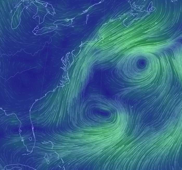
------------------------- The Wavecaster |
|
|
|
|
|
10/01/2014 10:51 AM
|
|
|
I'm to the point where making plans, other than surfing, gives me anxiety. I have good freinds (who don't partake) coming to town then, which I would normally be stoked about but nowww.. Bloody hell, are we destined to an existance of hesitance to make plans, and reluctance to follow through with them because it just might hinder one good surf.. Friends, weddings, family gigs, girlfriend oriented tasks..it's all possible pissing in the wind (& onshore at that).. What have we done to ourselves You guys crack me up! But I agree with PepperDeath also.... It's all about the surfing... ------------------------- Be Joyful because you have Hope, be Patient when trouble comes, Pray at all times. Romans 12:12 |
|
|
|
|
|
10/01/2014 11:03 AM
|
|
|
Nice Fetch! ------------------------- Replace turf grass with native plants that don't need irrigation and synthetic fertilizers or chemicals that can go into our waterways and ocean |
|
|
|
|
|
10/01/2014 05:00 PM
|
|
|
This news should be delivered by a "meteorologist" that looks like:
------------------------- 
|
|
|
|
|
|
10/01/2014 06:01 PM
|
|
|
Won't be any denial going on ,looking smaller and smaller as it gets closer to Sunday .Waist High to chest w N winds 10-15mph!! Hope I'm wrong but all models are showing decent fetch with not much size for two days then real small like obey says!!! ------------------------- Learn to read a buoy and check your winds and tides!!! Edited: 10/01/2014 at 11:14 PM by IHBlocdogg |
|
|
|
|
FORUMS
:
Surfing
:
NEXT WEEKEND (oct 4th/5th)
|
Topic Tools |
FuseTalk Basic Edition - © 1999-2024 FuseTalk Inc. All rights reserved.