
 |
2nd Light Forums |
 |
 |  |


|
Topic Title: ...DEPRESSION BECOMES TROPICAL STORM MARIA... Topic Summary: Created On: 09/16/2017 01:56 PM |
Linear : Threading : Single : Branch |
 |
- Central Floridave | - 09/16/2017 01:56 PM |
|
- dingpatch | - 09/16/2017 03:20 PM |
|
- dingpatch | - 09/16/2017 04:17 PM |
|
- ww | - 09/16/2017 06:39 PM |
|
- 3rdworldlover | - 09/16/2017 07:48 PM |
|
- Central Floridave | - 09/17/2017 09:47 AM |
|
- scostuart | - 09/17/2017 10:13 AM |
|
- dingpatch | - 09/17/2017 02:46 PM |
|
- dingpatch | - 09/17/2017 05:26 PM |
|
- Long Beard | - 09/17/2017 10:15 PM |
|
- dingpatch | - 09/18/2017 03:28 AM |
|
- RocketSurf | - 09/19/2017 07:14 AM |
|
- scombrid | - 09/19/2017 07:47 AM |
|
- TONYlookaround | - 09/19/2017 04:10 PM |
|
- dingpatch | - 09/19/2017 05:38 PM |
|
- scombrid | - 09/19/2017 05:51 PM |
|
- dkaye | - 09/19/2017 05:52 PM |
|
- scombrid | - 09/19/2017 05:57 PM |
|
- TONYlookaround | - 09/20/2017 06:36 AM |
|
- scombrid | - 09/19/2017 05:56 PM |
|
- Davidfrye | - 09/28/2017 03:22 AM |
|
- Central Floridave | - 09/18/2017 08:39 AM |
|
- Karma | - 09/18/2017 08:55 AM |
|
- harrietdubman | - 09/18/2017 09:59 AM |
|
- WG | - 09/18/2017 01:05 PM |
|
- Central Floridave | - 09/18/2017 05:21 PM |
|
- Central Floridave | - 09/18/2017 05:23 PM |
|
- ww | - 09/18/2017 08:30 PM |
|
- 3rdworldlover | - 09/18/2017 08:35 PM |
|
- paddleout | - 09/19/2017 06:51 PM |
|
- Central Floridave | - 09/19/2017 07:28 PM |
|
- Central Floridave | - 09/19/2017 07:29 PM |
|
- dkaye | - 09/19/2017 08:20 PM |
|
- paddleout | - 09/19/2017 09:21 PM |
|
- TONYlookaround | - 09/20/2017 01:38 AM |
|
- TONYlookaround | - 09/20/2017 01:50 AM |
|
- Central Floridave | - 09/20/2017 06:01 AM |
|
- Central Floridave | - 09/20/2017 08:01 AM |
|
- ww | - 09/20/2017 04:31 PM |
|
- johnnyboy | - 09/20/2017 05:51 PM |
|
- CERTON | - 09/20/2017 06:04 PM |
|
- dkaye | - 09/21/2017 04:52 AM |
|
- dkaye | - 09/21/2017 05:03 AM |
|
- dkaye | - 09/21/2017 05:05 AM |
|
- Karma | - 09/21/2017 09:51 AM |
|
- ww | - 09/22/2017 02:03 AM |
|
- Karma | - 09/22/2017 08:41 AM |
|
- ww | - 09/22/2017 05:21 PM |
|
- Central Floridave | - 09/22/2017 09:59 PM |
|
- Central Floridave | - 09/22/2017 10:00 PM |
|
- tom | - 09/23/2017 04:00 AM |
|
- Central Floridave | - 09/23/2017 07:39 AM |
|
- scostuart | - 09/23/2017 10:57 AM |
|
- 3rdworldlover | - 09/23/2017 05:39 PM |
|
- sharkey | - 09/23/2017 07:13 PM |
 Topic Tools Topic Tools
|

 09/16/2017 01:56 PM 09/16/2017 01:56 PM


|
|
|
NWS National Hurricane Center Miami FL AL152017
500 PM AST Sat Sep 16 2017 ...DEPRESSION BECOMES TROPICAL STORM MARIA... ...ADDITIONAL STRENGTHENING IS FORECAST... Tropical Storm Maria Discussion Number 2 NWS National Hurricane Center Miami FL AL152017 500 PM AST Sat Sep 16 2017 Satellite images indicate that the system located several hundred miles east of the Lesser Antilles has become much better organized throughout the day. The low-level center of circulation is now well defined, and banding features have become better established in all quadrants. The initial wind speed is increased to 45 kt, in agreement with a Dvorak classification from TAFB. This makes the system a tropical storm, Maria becomes the thirteenth named storm in the Atlantic basin this season. Maria is moving quickly westward at 17 kt on the south side of a mid-level ridge. This ridge is expected to remain in place but weaken some, which should cause Maria to move west-northwestward at a progressively slower pace through the forecast period. The models are in fair agreement, and the NHC official track forecast is closest to the HCCA model. This forecast takes the core of Maria near the Leeward Islands in 48 to 72 hours, and close to the Virgin Islands and Puerto Rico in about 4 days. The tropical storm is located within conducive environmental conditions of low wind shear, high amounts of moisture, and over warm 29 deg C SSTs. Since these conditions are not expected to change much, steady or even rapid strengthening is likely during the next 3 to 4 days. Slight weakening is predicted by the end of the forecast period due to some land interaction and a slight increase in wind shear. The NHC intensity forecast is raised significantly from the previous one to come into better agreement with the latest guidance. KEY MESSAGES: 1. Maria is expected to strengthen and affect portions of the Leeward Islands as a hurricane early next week, bringing dangerous wind, storm surge and rainfall hazards. Hurricane and tropical storm watches have been issued for portions of the Lesser Antilles, and additional watches will likely be issued tonight and Sunday. 2. Maria could also affect the British and U.S. Virgin Islands and Puerto Rico by mid week as a dangerous major hurricane, and hurricane watches could be issued for these islands as early as Sunday. Interests in these areas should monitor the progress of Maria and follow any advice given by local officials. FORECAST POSITIONS AND MAX WINDS INIT 16/2100Z 12.3N 52.6W 45 KT 50 MPH 12H 17/0600Z 13.0N 54.5W 55 KT 65 MPH 24H 17/1800Z 13.9N 56.6W 65 KT 75 MPH 36H 18/0600Z 14.6N 58.3W 70 KT 80 MPH 48H 18/1800Z 15.2N 59.8W 80 KT 90 MPH 72H 19/1800Z 16.5N 62.7W 95 KT 110 MPH 96H 20/1800Z 17.9N 65.5W 105 KT 120 MPH 120H 21/1800Z 19.5N 68.6W 95 KT 110 MPH |
|
|
|
|
|
09/16/2017 03:20 PM
|
|
|
Oh fooking goody!
------------------------- Dora Hates You |
|
|
|
|
|
09/16/2017 04:17 PM
|
|
|
Current model tracks have her going into PR as a Major!!
The guy who owns the rental house 2-doors-down from us has a home on St. John. He says that Irma fucked them raw, worse than Hugo or Marilyn. ------------------------- Dora Hates You |
|
|
|
|
|
09/16/2017 06:39 PM
|
|
|
Farther along, Maria could "pinwheel" Jose into the NJ coast via the Fujiwara effect. But that's foo far out to be an actual forecast. |
|
|
|
|
|
09/16/2017 07:48 PM
|
|
|
We have a long season ahead.
High octane heat in the Caribbean and GOMEX. |
|
|
|
|
|
09/17/2017 09:47 AM
|
|
|
Yeah for Football and Hurricane season starting at the same time! Survived Irma with lots of yard damage but the house stood. Pool screen gone. Oh well. Yeah for living in Florida. Its fun here, right?!?
I was a little itchy when I saw the long range models showing Marie skimming Florida. But, now doesn't show that anymore. Hoping for recurve and out in the Atlantic for more great surf! RECURVE RECURVE RECURVE.... |
|
|
|
|
|
09/17/2017 10:13 AM
|
|
|
https://www.tropicaltidbits.com/ ------------------------- Waiting for waves is ok......most people spend their lives waiting for nothing. |
|
|
|
|
|
09/17/2017 02:46 PM
|
|
|
ZCZC MIATCDAT5 ALL
TTAA00 KNHC DDHHMM Hurricane Maria Discussion Number 6 NWS National Hurricane Center Miami FL AL152017 500 PM AST Sun Sep 17 2017 A burst of deep convection developed over Maria's center since the last advisory and has continued to expand in size. The Air Force Hurricane Hunter aircraft investigating the cyclone found maximum flight-level winds of 63 kt and SFMR surface winds of 64 kt. The crew also noted the formation of an open eyewall. Based on these data and observations, Maria is upgraded to a 65-kt hurricane. The initial motion remains west-northwestward, or 283/13 kt. Maria is expected to maintain this trajectory for quite some time, but it will likely slow down during the next 36 hours as it approaches the Lesser Antilles. Overall, the track guidance is tightly clustered for the entire 5-day forecast period, which increases confidence in the NHC track forecast. The updated official forecast is slightly south of the previous one for the first 36 hours, mainly due to the update of the initial position found by the aircraft, but it is right along the previous track after 36 hours. This solution is between the GFS and ECMWF models and very close to the HCCA solution. The aircraft data indicate that Maria has a compact circulation, which could make it a prime candidate for significant intensification in an environment of low shear and warm SSTs. Rapid intensification indices are not especially high, but nonetheless, Maria is forecast to continue strengthening and potentially reach major hurricane by 48 hours. If that occurs, some fluctuations in intensity could occur due to eyewall replacements and land interaction, but Maria will likely remain as a major hurricane on days 3 through 5. Because of Maria's small size the chance of significant strengthening is higher, and the NHC intensity forecast is near the high end of the guidance, closest to the HWRF and HCCA models. ------------------------- Dora Hates You |
|
|
|
|
|
09/17/2017 05:26 PM
|
|
|
Neat graphic linked by Mike's Weather Page.
https://www.facebook.com/mikes...55526680572367/?type=3 ------------------------- Dora Hates You |
|
|
|
|
|
09/17/2017 10:15 PM
|
|
|
waves for days! wish i was there : (
------------------------- R I P Mama G. @Salt.And.Savagery.Fishing @Laserwolf.Laserwolf |
|
|
|
|
|
09/18/2017 03:28 AM
|
|
|
It is likely that after this one, PR is really going to be Tits Up. Likely direct hit by a 140 MPH Major.
------------------------- Dora Hates You |
|
|
|
|
|
09/19/2017 07:14 AM
|
|
|
waves for days! wish i was there : ( Ditto with a heavy heart.... |
|
|
|
|
|
09/19/2017 07:47 AM
|
|
|
I could barely believe the rate of intensification I was watching on the satellite loops and radar feed out of St. Martin yesterday and then the dead center crossing of Dominica. ------------------------- ... |
|
|
|
|
|
09/19/2017 04:10 PM
|
|
Hurricane Maria Summary
Maria has continued to strengthen this afternoon, with surface and
Color amplified cloud pattern - 2mile radius eye, 18mi radius eyewall . A small, fast moving storm/tornado. So.. one trip around this eyewall is 61.6n miles and that means it is spinning 2.4 times around an hour or 1 rotation every 25 minutes. So, at 10mph forward speed -- PR landfall is in the eye for 30 minutes and 1 rotation of the eye and then another hour of eyewall speed winds - that top 145 above 35 feet -- or 81kt ground speed max. island is 110 miles long, so thats 10 hours of eyewall marching over the island with a 30 minute rest to regroup -- and the eyes small, so this keeps n/s/e/w eyewall on land. figure 40 miles of intense wind = 4 hours of 81kt wind. However, there are mountains and much of the island is elevated -- so the north side would take the brunt on the approach and the south side take the brunt on the tail end. so would the mean only 2 hours of intense wind at each location ? in this case a 3D model would convey the impact best. PR has elevations of 3500-4400' above sea level. http://www.digitaldataservices.com/images/galleries/custom_mapping//04_puerto_rico_custom_map.jpg This adds an entirely new dimension to high winds and storms. To dodge the intensity of the storm go to the south side first and in the eye move to the north side as quickly as possible. with downed trees on roads its not as possible. So, will the 33-35' rule of 44% wind speed drop apply at all elevations or does that only apply at sea level, on level ground?
------------------------- it's never too late to have a happy childhood... Edited: 09/28/2017 at 07:01 AM by TONYlookaround |
|
|
|
|
|
09/19/2017 05:38 PM
|
|
|
Now 175 MPH.
------------------------- Dora Hates You |
|
|
|
|
|
09/19/2017 05:51 PM
|
|
What am I missing here ??
Just about everything.
------------------------- ... |
|
|
|
|
|
09/19/2017 05:52 PM
|
|
|
Tony is a dumbass ------------------------- https://www.instagram.com/dj_kaye_/ |
|
|
|
|
|
09/19/2017 05:57 PM
|
|
|
It is too bad we can't teleport him into the path so he can sit on a beach and smoke his shit in the gentle breeze. ------------------------- ... |
|
|
|
|
|
09/20/2017 06:36 AM
|
|
|
dkaye.. - were you asleep during physics in high school and drivers ed? Kenetic energy doubles every 10 miles an hour in a car, so the same would apply to flying debris in a storm that hits stationary objects. The point I make is that the reported wind speeds of the NHC are overstated and exagerated. ground speed is 44% less, meaning that the impressive 150mph number they report is 66 mph overstated (fortunately). The ground wind speed would be at a maximum of 84mph. I'm not sure the effect of the ground speed if a 12% grade is applied or the ground elevation ridge extends to 4,400'.
Watching the fly over video of Dominica - most buildings had roofs intact. Poorly built, sheet metal structures blew apart, homes in hollars seemed to have little to no damage (from the plane). That would be consistent with 84mph ground speed wind. ------------------------- it's never too late to have a happy childhood... Edited: 09/20/2017 at 08:40 AM by TONYlookaround |
|
|
|
|
|
09/19/2017 05:56 PM
|
|
|
Color amplified cloud pattern looks nice -
If you don't like the colors used to depict the temperature of the cloud tops you can always just look at raw infrared. Either way it doesn't "look nice". As cyclones go it is terrifying and looks nothing like any category 1 or 2 ever has since we've been sending satellites up to look at such things. Nor has there ever been a 909 surface pressure an anything that "probably used to be called a cat 1-2". ------------------------- ... |
|
|
|
|
|
09/28/2017 03:22 AM
|
|
|
Thanks for the information.. It will surely going to help us for future purpose. |
|
|
|
|
|
09/18/2017 08:39 AM
|
|
|
Hurricane Maria Discussion Number 9
NWS National Hurricane Center Miami FL AL152017 1100 AM AST Mon Sep 18 2017 Reports from an Air Force Reserve Hurricane Hunter aircraft indicate that Maria is undergoing rapid intensification. The aircraft reported 700-mb flight-level winds of 115 kt in the northeastern eyewall, along with reliable-looking surface wind estimates from the Stepped Frequency Microwave radiometer as high as 104 kt. In addition, the estimated central pressure inside the 10 n mi wide eye has fallen to 959 mb. The initial intensity is increased to 100 kt, making Maria a major category 3 hurricane on the Saffir-Simpson Hurricane Wind Scale. The small eye is also apparent in radar data from Martinique. The initial motion is 285/9, a little to the left of the previous motion. Other than that, there is little change in either the forecast philosophy or the forecast track. A high pressure area to the north of Maria should maintain a general west-northwestward motion for the next three days or so. After that, the high weakens, which should allow the hurricane to turn gradually northwestward and north-northwestward. The new forecast track is changed little from the previous one, and it calls for Maria to move through the Leeward Islands in 12-24 h, approach the Virgin Islands in about 36 h, then cross Puerto Rico between 48-72 h. The new track lies to the left of the center of the guidance envelope in best agreement with the ECMWF. Atmospheric and oceanic conditions appear favorable for additional rapid strengthening for the next 24 h and possibly longer. This is reflected in the intensity forecast, which now calls for Maria to become a category 4 hurricane in 12 h and reach a possibly conservative peak intensity of 130 kt in about 36 h. From 72-120 h, land interaction and less favorable upper-level winds are expected to cause some weakening. On top of these general trends, there is also the possibility that eyewall replacement cycles could occur that would affect the intensity. However, Maria is likely to maintain category 3 to 4 intensity through the forecast period. KEY MESSAGES: 1. Maria will affect portions of the Leeward Islands and the British and U.S. Virgin Islands as an extremely dangerous major hurricane during the next couple of days, and hurricane warnings are in effect for many of these islands. 2. Maria is likely to affect Puerto Rico as an extremely dangerous major hurricane, and a hurricane watch is in effect for that island. A hurricane warning will likely be issued later today. 3. The potential for a life-threatening storm surge, accompanied by large and destructive waves, has increased for the Leeward Islands, the Virgin Islands, and Puerto Rico. 4. Life-threatening flash floods and mudslides from heavy rainfall are expected across the Leeward Islands, including Puerto Rico and the U.S. and British Virgin Islands. FORECAST POSITIONS AND MAX WINDS INIT 18/1500Z 14.7N 60.1W 105 KT 120 MPH 12H 19/0000Z 15.1N 61.2W 115 KT 130 MPH 24H 19/1200Z 15.9N 62.6W 125 KT 145 MPH 36H 20/0000Z 16.8N 64.1W 130 KT 150 MPH 48H 20/1200Z 17.6N 65.5W 130 KT 150 MPH 72H 21/1200Z 19.5N 68.5W 125 KT 145 MPH 96H 22/1200Z 21.5N 71.0W 120 KT 140 MPH 120H 23/1200Z 24.0N 72.5W 110 KT 125 MPH |
|
|
|
|
|
09/18/2017 08:55 AM
|
|
|
Farm house in the cross hairs again.
------------------------- If you're not part of the solution, you're part of the precipitate. |
|
|
|
|
|
09/18/2017 09:59 AM
|
|
|
the funderground railroad never stops ------------------------- sneedeker |
|
|
|
|
|
09/18/2017 01:05 PM
|
|
|
Lot's more heat in these waters these days...
------------------------- "The truth is incontrovertible. malice may attack it, ignorance may deride it, but in the end, there it is." -Sir Winston Churchill |
|
|
|
|
|
09/18/2017 05:21 PM
|
|
|
NWS National Hurricane Center Miami FL AL152017
800 PM AST Mon Sep 18 2017 ...MARIA BECOMES A POTENTIALLY CATASTROPHIC CATEGORY 5 HURRICANE... ...THE EYE AND THE INTENSE INNER CORE IS NEARING DOMINICA... MAXIMUM SUSTAINED WINDS...160 MPH |
|
|
|
|
|
09/18/2017 05:23 PM
|
|
|
Hurricane Maria Special Discussion Number 11
NWS National Hurricane Center Miami FL AL152017 800 PM AST Mon Sep 18 2017 This special advisory is being issued to increase the initial and forecast intensity of Maria. Recent reports from an Air Force Reserve Hurricane Hunter aircraft indicate that Maria continues to rapidly strengthen. The aircraft measured SFMR winds of 139 kt in the northwest eyewall and an estimated minimum pressure of 925 mb, based on dropsonde data. Based on these observations, the initial intensity of Maria has been increased to 140 kt, making Maria a potentially catastrophic category 5 hurricane on the Saffir-Simpson Hurricane Wind Scale. Some additional strengthening is possible during the next 24 hours, but fluctuations in intensity are likely due to eyewall cycles and land interaction. No change was made to the previous track forecast, and the extremely dangerous core of Maria is expected to pass over Dominica within the next hour or two. KEY MESSAGES: 1. Maria will affect portions of the Leeward Islands and the British and U.S. Virgin Islands as an extremely dangerous major hurricane during the next couple of days, and hurricane warnings are in effect for many of these islands. 2. Maria is likely to affect Puerto Rico as an extremely dangerous major hurricane, and a hurricane warning has been issued for that island. 3. The potential for a life-threatening storm surge, accompanied by large and destructive waves, has increased for the Leeward Islands, the Virgin Islands, and Puerto Rico. 4. Life-threatening flash floods and mudslides from heavy rainfall are expected across the Leeward Islands, including Puerto Rico and the U.S. and British Virgin Islands. FORECAST POSITIONS AND MAX WINDS INIT 19/0000Z 15.3N 61.1W 140 KT 160 MPH 12H 19/0600Z 15.7N 61.9W 145 KT 165 MPH 24H 19/1800Z 16.5N 63.3W 145 KT 165 MPH 36H 20/0600Z 17.3N 64.7W 140 KT 160 MPH 48H 20/1800Z 18.2N 66.2W 130 KT 150 MPH 72H 21/1800Z 20.0N 69.0W 125 KT 145 MPH 96H 22/1800Z 22.0N 71.5W 120 KT 140 MPH 120H 23/1800Z 25.0N 73.0W 105 KT 120 MPH |
|
|
|
|
|
09/18/2017 08:30 PM
|
|
|
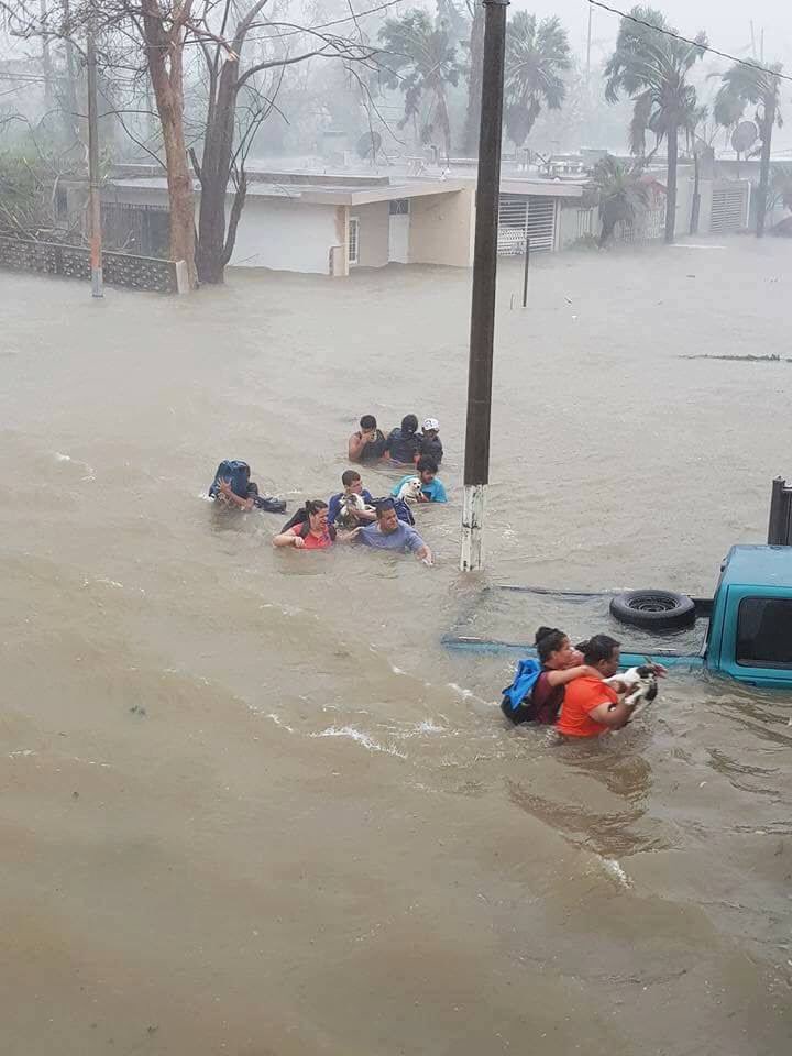
Landfall at Dominica, the first category 5 in its history. It could become Puerto Rico's first category 5 since the San Felipe Segundo/Okeechobee hurricane of 1928, the one that killed 2,500-3,000 people in Florida. |
|
|
|
|
|
09/18/2017 08:35 PM
|
|
|
This is terrible
|
|
|
|
|
|
09/19/2017 06:51 PM
|
|
|
|
|
|
09/19/2017 07:28 PM
|
|
|
Radar without the advertisement from above link:
Puerto Rico Radar: http://radar.weather.gov/ridge...rlay=11101111&loop=yes |
|
|
|
|
|
09/19/2017 07:29 PM
|
|
|
Reports from an Air Force Reserve Hurricane Hunter aircraft
indicate that maximum sustained winds are near 175 mph (280 km/h) with higher gusts. Maria is a potentially catastrophic category 5 hurricane on the Saffir-Simpson Hurricane Wind Scale. Some fluctuations in intensity are likely during the next day or so, but Maria is forecast to remain an extremely dangerous category 4 or 5 hurricane as it moves near or over the Virgin Islands and Puerto Rico. Slow weakening is expected after the hurricane emerges over the Atlantic north of Puerto Rico and the Dominican Republic. |
|
|
|
|
|
09/19/2017 08:20 PM
|
|
|
It's crazy to think that a cat 5 storm is FIFTY times more destructive than a cat 1 storm PR already has such a problem with their infrastructure anyway. The mayor of San Juan was crying earlier on CNN. So Sad. ------------------------- https://www.instagram.com/dj_kaye_/ |
|
|
|
|
|
09/19/2017 09:21 PM
|
|
|
it really is horrible. Having just gone through a small hurricane ourselves and having Gone without power /AC for just a few days it sucked so immensely I can't even fathom what a storm that powerful would be like.. I imagine one would be terrified for their life and their families lives.. and that doesnt take into account the sheer amount of destruction and suffering that will come in the next 24 hours.. its really heartbreaking
|
|
|
|
|
|
09/20/2017 01:38 AM
|
|
|
this is sad.
------------------------- it's never too late to have a happy childhood... Edited: 09/20/2017 at 01:57 AM by TONYlookaround |
|
|
|
|
|
09/20/2017 01:50 AM
|
|
|
landfall right now in PR. Pray for these US citizens!
worse is -- in the middle of the night.
------------------------- it's never too late to have a happy childhood... |
|
|
|
|
|
09/20/2017 06:01 AM
|
|
|
NWS National Hurricane Center Miami FL AL152017
800 AM AST Wed Sep 20 2017 ...EYE OF MARIA LOCATED OVER EASTERN PUERTO RICO... landed with 150 mph. |
|
|
|
|
|
09/20/2017 08:01 AM
|
|
|
Looks like the Puerto Rico Radar was taking out. Ugh. Poor Puerto Rico.
|
|
|
|
|
|
09/20/2017 04:31 PM
|
|
|
As of 5 pm Atlantic time (4 Eastern), Maria was 25 mi NNW of Aguadilla, category 2. |
|
|
|
|
|
09/20/2017 05:51 PM
|
|
|
It's going to very hard to recover from this. Very primitive conditions for probably six months.
------------------------- "One of the reasons why propaganda tries to get you to hate government is because it's the one existing institution in which people can participate to some extent and constrain tyrannical unaccountable power." Noam Chomsky. |
|
|
|
|
|
09/20/2017 06:04 PM
|
|
|
Looks like it went corner to corner across PR any updates from Aguadilla?
------------------------- "Don't count the days, make the days count." -Ali #rydyrstrong |
|
|
|
|
|
09/21/2017 04:52 AM
|
|
|
all hype right tony? PR without power for 4-6 months and the "fake news" media made up this whole thing lol hope you don't have any family down there ------------------------- https://www.instagram.com/dj_kaye_/ |
|
|
|
|
|
09/21/2017 05:03 AM
|
|
|
more fake news http://www.chicagotribune.com/news/nationworld/ct-puerto-rico-hurricane-maria-20170921-story.html all these fake hurricanes sure seem to be making a mess of the carribean (dumb ass) ------------------------- https://www.instagram.com/dj_kaye_/ |
|
|
|
|
|
09/21/2017 05:05 AM
|
|
|
------------------------- https://www.instagram.com/dj_kaye_/ |
|
|
|
|
|
09/21/2017 09:51 AM
|
|
|
I had a friend who went to Guarabo to be with close friends and family. That's right by Caguas, where the eye went over. He is an ag student at UPR Mayaguez and has been staying at my farm to help maintain and keep the vines in check. He did fine through the storm but said it was some seriously intense shit. I have still not heard from my neighbors on whether my little tin roof wooden shack in the holler is still standing over in the Mayaguez mountainous region. Today is the anniversary of my purchase. Last year on this day, they had El Gran Apagon. The Milky Way viewing was spectacular and people kept their cool. PR is a very cohesive and mutually supportive society, especially in the countryside. The power outage last year lasted over a week and people were very calm throughout. My key set came with a Virgin Maria pendant. More than a few ironies. I still have no regret. Sure there are downsides to the society, but I have been met with open arms and blessings by each person I have met there. I look forward to moving there some day and doing everything I can to help improve the situation on the island.
Puerto Ricans are Americans, just as Virgin Islanders are Americans. I sincerely hope we show our love for them as part of our union and come to their aid. My next scheduled trip down is in November. I hope I have a home to stay in so that I can assist my neighbors anyway possible. ------------------------- If you're not part of the solution, you're part of the precipitate. |
|
|
|
|
|
09/22/2017 02:03 AM
|
|
|
El Nuevo Día seems as good a source as any. One item from them: "12:11 p.m. -Residentes de Isabela reportan daños en el pueblo y barrio La Marina. Inundaciones en las vías principales, barrio Jobos y entrada de La Cara del Indio. Árboles y cables de energía eléctrica en el suelo. 12:11 p.m. -Residents of Isabela report damage in the town and La Marina neighborhood. Flooding in main streets, Jobos neighborhood and entranct of La Cara del Indio. Trees and electric lines on the ground. I think it may be the end for the great radio telescope in the haystack hills south of Arecibo. It's been losing funding for years and would seem unlikely to get much funding for repairs. Video from Utuado up in the mountains is discouraging. Edited: 09/22/2017 at 02:20 AM by ww |
|
|
|
|
|
09/22/2017 08:41 AM
|
|
|
I have a good friend whose family lives in Utuado. One of my favorite places in PR. Her place is high above Rio Limon, but man oh man is that river powerful!
------------------------- If you're not part of the solution, you're part of the precipitate. |
|
|
|
|
|
09/22/2017 05:21 PM
|
|
|
Guajataca Dam may fail, so 70,000 people have to evacuate. As if roads were in condition for that. Washington Post: "The dam, built by the Army Corps of Engineers in 1929, suffered a "fissure," Gov. Ricardo Rosselló said in a news conference Friday. An estimated 70,000 people in the municipalities of Quebradillas, Isabela and part of San Sebastian could be affected if the dam collapses, he said." Edited: 09/22/2017 at 05:29 PM by ww |
|
|
|
|
|
09/22/2017 09:59 PM
|
|
|
NWS National Hurricane Center Miami FL AL152017
1100 PM EDT Fri Sep 22 2017 A NOAA Hurricane Hunter plane and the Coyote unmanned aerial vehicle launched from the NOAA plane have sampled the eye and the surroundings of Maria early this evening. An Air Force plane also arrived and so far has penetrated the eye a couple of times. Based on the data from these platforms, the maximum winds are still 110 kt in the eyewall that surrounds a large eye of about 35 n mi in diameter. There are no reports of a double wind max at this time so no eyewall replacement cycle is anticipated soon. The current shear is forecast to decrease, but the hurricane is moving toward a region with less oceanic heat content. The combination of these two factors should result in a very gradual decay of the hurricane, and the NHC forecast keeps Maria as a category 3 at least for one or two more days. Satellite and plane fixes indicate that Maria is moving toward the north-northwest or 345 degrees at 8 kt, steered by a subtropical ridge to the east of the hurricane. The ridge is forecast to amplify westward during the next few days, but it is not expected to be strong enough to block the northward motion of the hurricane. It will however, force the hurricane to move slowly. Tonight's guidance continues to be in very good agreement for the next 3 days, and the NHC forecast is in the middle of the tight envelope. After that time, the GFS and EMWF are once again in competition, with the GFS defining the western edge of the guidance envelope and the ECMWF the eastern one. This makes the forecast a little more uncertain. The NHC forecast recurves Maria over the open Atlantic which is the solution of the HFIP corrected consensus and the multi-model consensus. KEY MESSAGES: 1. Swells from Maria are expected to increase along the coast of the southeastern United States and will likely cause dangerous surf and life-threatening rip currents for the next several days. 3. Maria will move between the east coast of the United States and Bermuda by the middle of next week, but it is too soon to determine what, if any, direct impacts there might be in these areas. 4. For more information on the flooding and rip current hazards in the United States, please monitor information from your local National Weather Service forecast office at www.weather.gov. FORECAST POSITIONS AND MAX WINDS INIT 23/0300Z 24.1N 71.7W 110 KT 125 MPH 12H 23/1200Z 25.3N 72.1W 110 KT 125 MPH 24H 24/0000Z 27.0N 72.4W 105 KT 120 MPH 36H 24/1200Z 28.5N 72.7W 100 KT 115 MPH 48H 25/0000Z 29.7N 72.8W 95 KT 110 MPH 72H 26/0000Z 31.7N 72.4W 85 KT 100 MPH 96H 27/0000Z 33.5N 72.3W 75 KT 85 MPH 120H 28/0000Z 35.5N 71.0W 65 KT 75 MPH |
|
|
|
|
|
09/22/2017 10:00 PM
|
|
|
Woot!
|
|
|
|
|
|
09/23/2017 04:00 AM
|
|
|
GFS run this AM suggests Outer Banks get a hit or near miss ------------------------- add a signature since I'm here in profile anyway |
|
|
|
|
|
09/23/2017 07:39 AM
|
|
|
NE bahama buoy HUUUUUGEEEE 24+ feet!
INCOMMING.... http://www.ndbc.noaa.gov/station_page.php?station=41047 |
|
|
|
|
|
09/23/2017 10:57 AM
|
|
|
Going to be interesting to see how much worse the beach erosion will be locally..... ------------------------- Waiting for waves is ok......most people spend their lives waiting for nothing. |
|
|
|
|
|
09/23/2017 05:39 PM
|
|
|
It got through the slot down south today.
|
|
|
|
|
|
09/23/2017 07:13 PM
|
|
|
Have sent a donation to the Salvation Army and would welcome info about what PR residents can use and how to get it to them. |
|
|
|
|

|
FORUMS
:
Surfing
:
...DEPRESSION BECOMES TROPICAL STORM MARIA...
|
Topic Tools |
FuseTalk Basic Edition - © 1999-2024 FuseTalk Inc. All rights reserved.