
 |
2nd Light Forums |
 |
 |  |


|
Topic Title: TD #8. T.S. Henri Topic Summary: Nice spot for a storm to flare up! Created On: 08/16/2021 04:36 AM |
Linear : Threading : Single : Branch |
|
 Topic Tools Topic Tools
|

 08/18/2021 01:10 AM 08/18/2021 01:10 AM


|
|
|
------------------------- ola ~ |
|
|
|
|
|
08/18/2021 03:07 AM
|
|
|
00Z model runs (Wed morning) still doesn't make this a major swell maker. hmm...Strange.
|
|
|
|
|
|
08/18/2021 03:10 AM
|
|
|
Tropical Storm Henri Discussion Number 10
NWS National Hurricane Center Miami FL AL082021 500 AM AST Wed Aug 18 2021 There's been little change in Henri's satellite appearance this morning. The surface center is still located just to the northwest of a gradually expanding central dense overcast, and there still appears to be an eye-like feature in the Bermuda Doppler radar presentation. However, there are no indications in the GOES-16 BD-curve enhanced infrared images of a developing warm spot. Subjective and objective satellite intensity estimates remain steady, and the initial intensity is held at 55 kt for this advisory. Although the surrounding thermodynamic environment is ripe for further significant development, moderate northwesterly shear continues to impinge on the cyclone causing difficulty in inner-core convective development. Consequently, little change in strength is expected during the next couple days, and in fact the statistical SHIPS model indicates an increase in a more northerly shear component on Thursday. By Saturday afternoon, however, the shear should decrease as the cyclone slides beneath an upper ridge axis off of the southeast U.S. coast. Henri is expected to further intensity through the remaining period as the upper-wind flow becomes much more diffluent. The official intensity forecast is similar to the previous advisory, and lies between the SHIPS model and the HFIP Corrected Consensus Approach aid after the 60-hour period. The initial motion is estimated to be westward, or 260/7 kt. A high amplitude mid- to upper-level anticyclone situated north-northeast of Henri should steer the cyclone toward the west during the next 36 hours, or so. Thereafter, the aforementioned ridge is forecast to weaken and shift eastward in response to a mid-latitude shortwave trough moving over the northeastern U.S. As a result of the change in the synoptic steering pattern, Henri should turn toward the northwest, north, and then northeast through the remaining portion of the forecast. With so much uncertainty or spread in the global and regional models beyond day 3, the best approach at this point is to base the NHC forecast on the better performing multi-model consensus guidance, which has once again shifted a bit to the left of the previous track forecast. I think it's worth noting that the GFSv16 model is now showing a shortwave ridge building over eastern Canada on Sunday, which causes Henri to move more northward toward the New England coast. Therefore, additional changes or shifts of the track beyond the 60-hour period may be required on subsequent advisories. Due to the increased uncertainty in the track forecast, interests along the New England coast should monitor the progress of Henri. FORECAST POSITIONS AND MAX WINDS INIT 18/0900Z 30.1N 65.7W 55 KT 65 MPH 12H 18/1800Z 29.9N 66.9W 60 KT 70 MPH 24H 19/0600Z 29.8N 68.7W 60 KT 70 MPH 36H 19/1800Z 29.8N 70.6W 60 KT 70 MPH 48H 20/0600Z 30.4N 71.8W 60 KT 70 MPH 60H 20/1800Z 31.4N 72.3W 65 KT 75 MPH 72H 21/0600Z 33.0N 71.9W 70 KT 80 MPH 96H 22/0600Z 37.6N 69.0W 75 KT 85 MPH 120H 23/0600Z 40.5N 66.1W 65 KT 75 MPH |
|
|
|
|
|
08/18/2021 04:35 AM
|
|
|
Appears we should get some type of a swell from Henri.
|
|
|
|
|
|
08/18/2021 04:39 AM
|
|
|
|
|
|
|
|
|
08/18/2021 06:03 AM
|
|
|
If GFS forecast holds =

|
|
|
|
|
|
08/18/2021 06:10 AM
|
|
|
2-4' @ 11-12 seconds Friday afternoon per GFS wave model
|
|
|
|
|
|
08/18/2021 06:17 AM
|
|
|
|
|
|
|
|
|
08/18/2021 07:09 AM
|
|
|
The internet told me to be hopeful. The internet told me to forget about it. Open your eyes, figure it out for yourself.
|
|
|
|
|
|
08/18/2021 08:45 AM
|
|
|
I will go!!!! Then I will decide about the internet.
------------------------- "One of the reasons why propaganda tries to get you to hate government is because it's the one existing institution in which people can participate to some extent and constrain tyrannical unaccountable power." Noam Chomsky. |
|
|
|
|
|
08/18/2021 08:56 AM
|
|

|
|
|
|
|
|
08/18/2021 08:58 AM
|
|
|
|
|
|
|
|
|
08/18/2021 09:01 AM
|
|
|
I literally walk across the street half dozen times a day to look at the actual wave I'm going to surf . I still spend hours a day on the net looking at predictions and cams. Stop worrying about what I do. If everyone stopped telling peeps what to do on social media Maybe folks wouldn't b so angry when they get in the water w actual surf. LOL ... and if me telling u to stop telling me what to do is part of the problem then ur hopeless.
|
|
|
|
|
|
08/18/2021 09:25 AM
|
|
|
Does anyone think the positioning of Henri in any way resembles Kyle?
------------------------- So if you are a surfer I wish you the prosperity that allows you more time to pursue the salt water dream, and the true happiness that comes from warm water, clean waves and the companionship of your fellow surfers. If you are an internet troll just spewing bs then f off. |
|
|
|
|
|
08/18/2021 09:33 AM
|
|
|
Wavemaker, yeah
I love that track, felt like we haven't had one of these in a while |
|
|
|
|
|
08/18/2021 09:44 AM
|
|
|
|
|
|
|
|
|
08/18/2021 09:54 AM
|
|
|
ASCAT finally made a pass in the region.... you can see the windfield is pretty small (tiny compared to Grace) so moving west to 72+ will greatly increase size potential for our surf.....
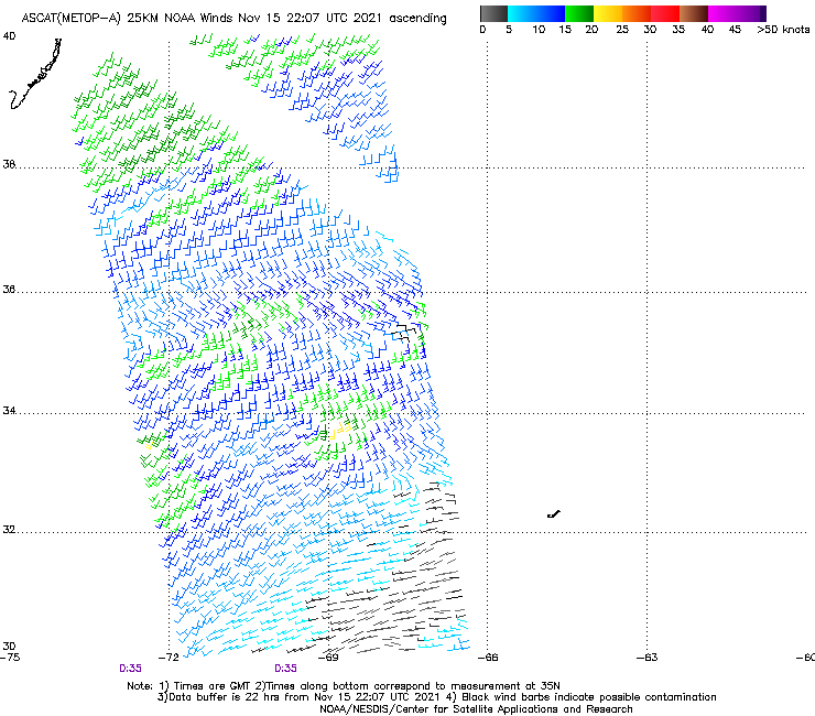  still excited about the potential to able to ride a regular shortboard though still excited about the potential to able to ride a regular shortboard though Edited: 08/18/2021 at 09:56 AM by Plan B |
|
|
|
|
|
08/18/2021 10:19 AM
|
|
|
yes to the "regular shortboard". Been riding my 5'!!" Neilson thruster if it gets any push. mega shakas...
|
|
|
|
|
|
08/18/2021 01:42 PM
|
|
|
Virtual buoys finally responded with better data. Check your favorite wave models (unless you are chopola and just stick your finger in the air for wind direction and wait to see people run across A1A with boards to know there are waves.
|
|
|
|
|
|
08/18/2021 02:07 PM
|
|
|
Why do the tides have to ruin the party?
------------------------- Ah, religion, bigotry dressed up as morality. |
|
|
|
|
FORUMS
:
Surfing
:
TD #8. T.S. Henri
|
Topic Tools |
FuseTalk Basic Edition - © 1999-2024 FuseTalk Inc. All rights reserved.