
 |
2nd Light Forums |
 |
 |  |


|
Topic Title: Tropics strangely quiet now Topic Summary: Created On: 09/25/2020 11:47 AM |
Linear : Threading : Single : Branch |
 |
- sw | - 09/25/2020 11:47 AM |
|
- Central Floridave | - 09/25/2020 01:13 PM |
|
- Cole | - 09/25/2020 07:14 PM |
|
- sw | - 09/29/2020 06:46 AM |
|
- GreenLantern | - 09/29/2020 06:49 AM |
|
- ncsurf | - 09/29/2020 07:57 AM |
|
- Plan B | - 09/29/2020 08:15 AM |
|
- Cole | - 09/29/2020 10:38 AM |
|
- sw | - 09/29/2020 01:23 PM |
|
- Plan B | - 09/30/2020 06:36 AM |
|
- SurferMic | - 09/30/2020 07:18 AM |
|
- Plan B | - 09/30/2020 07:26 AM |
|
- Plan B | - 10/02/2020 09:00 AM |
|
- johnnyboy | - 10/02/2020 09:17 AM |
|
- dingpatch | - 10/05/2020 05:23 AM |
|
- Central Floridave | - 10/05/2020 05:54 PM |
|
- dingpatch | - 10/06/2020 05:05 AM |
|
- Plan B | - 10/06/2020 05:18 AM |
|
- SurferMic | - 10/06/2020 07:02 AM |
|
- Plan B | - 10/06/2020 07:12 AM |
|
- Plan B | - 10/06/2020 08:40 AM |
|
- scostuart | - 10/06/2020 05:56 PM |
|
- Plan B | - 10/07/2020 06:13 AM |
|
- seaspray | - 10/22/2020 10:38 AM |
|
- LaJune | - 10/22/2020 11:15 AM |
|
- scombrid | - 10/23/2020 02:03 AM |
|
- Plan B | - 10/23/2020 03:27 AM |
|
- Plan B | - 10/23/2020 06:15 AM |
|
- fishkller | - 10/07/2020 01:21 PM |
|
- dingpatch | - 10/07/2020 01:28 PM |
|
- Plan B | - 10/08/2020 06:45 AM |
|
- long_flaco1 | - 10/08/2020 06:54 AM |
|
- RiddleMe | - 10/08/2020 07:32 AM |
|
- dingpatch | - 10/08/2020 07:41 AM |
|
- Plan B | - 10/11/2020 07:02 AM |
|
- Cole | - 10/11/2020 08:20 AM |
|
- LaJune | - 10/12/2020 01:29 PM |
|
- long_flaco1 | - 10/12/2020 06:30 AM |
|
- LBLarry | - 10/12/2020 05:42 PM |
|
- ww | - 10/12/2020 10:10 PM |
|
- Plan B | - 10/13/2020 08:16 AM |
|
- Skunkape | - 10/14/2020 12:37 PM |
|
- Greensleeves | - 10/14/2020 01:47 PM |
|
- Plan B | - 10/15/2020 07:07 AM |
|
- Plan B | - 10/17/2020 04:58 AM |
|
- Plan B | - 10/18/2020 05:04 AM |
|
- Plan B | - 10/19/2020 01:33 PM |
|
- SurferMic | - 10/20/2020 09:57 AM |
|
- Plan B | - 10/20/2020 10:46 AM |
|
- Plan B | - 10/20/2020 01:51 PM |
|
- Plan B | - 10/21/2020 05:58 AM |
|
- Plan B | - 10/21/2020 08:30 AM |
|
- Plan B | - 10/21/2020 08:43 AM |
|
- Cole | - 10/21/2020 08:44 AM |
|
- SurferMic | - 10/21/2020 11:19 AM |
|
- seaspray | - 10/21/2020 11:55 AM |
|
- surferclimber | - 10/22/2020 08:58 AM |
|
- Plan B | - 10/21/2020 12:11 PM |
|
- ww | - 10/21/2020 12:42 PM |
|
- Plan B | - 10/22/2020 04:24 AM |
|
- Plan B | - 10/22/2020 04:26 AM |
|
- Cole | - 10/22/2020 07:13 AM |
|
- dingpatch | - 10/22/2020 07:26 AM |
|
- Central Floridave | - 10/23/2020 07:22 AM |
|
- seaspray | - 10/23/2020 07:28 AM |
 Topic Tools Topic Tools
|

 09/25/2020 11:47 AM 09/25/2020 11:47 AM


|
|
|
Today:
 Exactly two weeks ago: 
|
|
|
|
|
|
09/25/2020 01:13 PM
|
|
|
Time to get some yard work done!
|
|
|
|
|
|
09/25/2020 07:14 PM
|
|
|
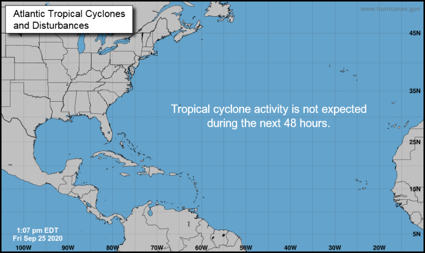
Tropics strangely quiet now
Good. ------------------------- I was right. |
|
|
|
|
|
09/29/2020 06:46 AM
|
|
|
Still totally quiet in the tropics...very strange
|
|
|
|
|
|
09/29/2020 06:49 AM
|
|
|
not strange for 2020
|
|
|
|
|
|
09/29/2020 07:57 AM
|
|
|
|
|
|
|
|
|
09/29/2020 08:15 AM
|
|


|
|
|
|
|
|
09/29/2020 10:38 AM
|
|
|
Yes, the gulf coast needs another storm. Gulf storms are usually the case early in the season, does this mean we will have them up the East Coast till New Year?
Another couple of weeks of 40 knot east winds will be cool though. Said no one ever. ------------------------- I was right. Edited: 09/29/2020 at 10:40 AM by Cole |
|
|
|
|
|
09/29/2020 01:23 PM
|
|
|
Still totally quiet in the tropics...very strange Other than that 50% chance in the next 5 days over the NW Caribbean, right? Ahhh...yes, you are correct...didn't check the 5-day! |
|
|
|
|
|
09/30/2020 06:36 AM
|
|
|
Granted, take this with a UUGE grain of salt given its over 10 days out..... but I'm pretty sure the Panhandle could do without ANOTHER major hurricane.
 Dont look at the GFS Para (experimental Beta version)
 |
|
|
|
|
|
09/30/2020 07:18 AM
|
|
|
.
Edited: 10/06/2020 at 07:30 PM by SurferMic |
|
|
|
|
|
09/30/2020 07:26 AM
|
|
|
|
|
|
|
|
|
10/02/2020 09:00 AM
|
|

|
|
|
|
|
|
10/02/2020 09:17 AM
|
|
|
Rain and wind that is producing very little to surf.
------------------------- "One of the reasons why propaganda tries to get you to hate government is because it's the one existing institution in which people can participate to some extent and constrain tyrannical unaccountable power." Noam Chomsky. |
|
|
|
|
|
10/05/2020 05:23 AM
|
|
|
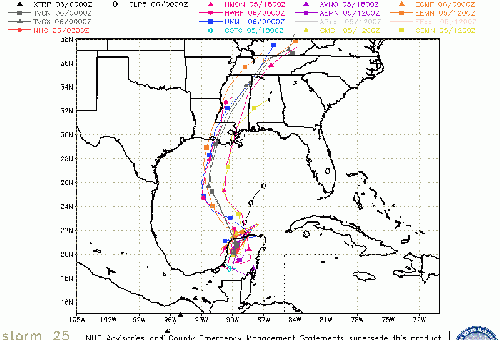
Delta looks like it is going to hit Louisiana as a CAT 2. Then, the long rand models are showing the remnants of Gamma heading up that way too.

------------------------- Dora Hates You |
|
|
|
|
|
10/05/2020 05:54 PM
|
|
|
Tropical Storm Delta Discussion Number 5
NWS National Hurricane Center Miami FL AL262020 500 PM EDT Mon Oct 05 2020 Visible satellite imagery shows that the convective banding of Delta has continued to quickly improve since this morning. The primary convective band now wraps entirely around the center, with what appears to be a banding-type eye feature occasionally noted. There are some dry slots between the convective bands but those appear to be gradually filling in. A NOAA Hurricane Hunter aircraft currently collecting data in the storm environment found peak SFMR winds of 55 kt during its first pass through the center from northwest to southeast. The plane also reported a minimum pressure of 983 mb, much lower than previously estimated. The aircraft also observed an 18 nmi-wide-eye that was open to the west-northwest. Assuming that there are stronger winds yet to be sampled in the northeastern quadrant, the initial intensity has been raised to 60 kt. Delta is situated within a very conducive environment for strengthening. The storm will be moving over SSTs of 29-30 degrees Celsius and the vertical wind shear is forecast to remain 5 kt or less while Delta traverses the northwestern Caribbean. These conditions are expected to allow for rapid strengthening over the next 24 to 36 hours. The SHIPS Rapid Intensification Index gives a better than 50 percent chance of a 35-40 kt increase in wind speed over the next 24 hours. The NHC intensity forecast follow suit by calling for rapid intensification over the next day or so, and Delta is forecast to be a major hurricane when is passes near or over the northeastern portion of the Yucatan peninsula. Once the storm reaches the central Gulf of Mexico in 60-72 hours, increasing southwestern vertical wind shear and cooler shelf waters over the northern Gulf are likely to result in some reduction in wind speed as the system nears the northern Gulf coast. Although there is still significant uncertainty regarding Delta's intensity when it nears the northern Gulf coast, it is becoming increasing likely that the system will pose a significant wind and storm surge threat to a portion of that area. The center has jogged southward again this afternoon, which appears to be primarily due to the system organizing rather than a true storm motion. The initial motion estimate remains an uncertain 275/7 kt. Delta should begin moving west-northwestward this evening, and a west-northwestward to northwestward motion around the southwestern portion of a deep-layer ridge to its northeast is expected over the next couple of days. The more southward initial position and more ridging over the eastern Gulf of Mexico has resulted in a significant westward shift in the track envelope through the first 60-72 hours. The NHC has been adjusted in that direction, and this has required the issuance of a Hurricane Warning for the northeastern portion of the Yucatan peninsula of Mexico. After 72 hours, a mid- to upper-level trough is forecast to develop over Texas which should cause Delta to turn northward and then north-northeastward toward the northern Gulf Coast. Although the track forecast has not changed much during the latter portion of the period, there is more cross-track spread in the model guidance than before, which has increased the uncertainty regarding potential landfall and the timing of Delta's approach to the northern Gulf Coast. Key Messages: 1. Dangerous storm surge and hurricane conditions are expected within portions of the northern Yucatan Peninsula of Mexico and are possible in extreme western Cuba beginning Tuesday night, and a Hurricane Warning is in effect. 2. Heavy rainfall will affect portions of Jamaica, the Cayman Islands, western Cuba and the northern Yucatan Peninsula during the next few days. This rainfall could lead to significant flash flooding and mudslides. 3. Tropical storm conditions are expected in portions of the Cayman Islands beginning tonight or early Tuesday, and a Tropical Storm Warning is in effect. 4. Delta is forecast to approach the northern Gulf Coast late this week as a hurricane. While there is large uncertainty in the track and intensity forecasts, there is an increasing risk of dangerous storm surge, wind, and rainfall hazards along the coast from Louisiana to the western Florida Panhandle beginning Thursday night or Friday. Residents in these areas should ensure they have their hurricane plan in place and monitor updates to the forecast of Delta. FORECAST POSITIONS AND MAX WINDS INIT 05/2100Z 16.2N 79.4W 60 KT 70 MPH 12H 06/0600Z 17.1N 80.9W 75 KT 85 MPH 24H 06/1800Z 19.0N 83.5W 95 KT 110 MPH 36H 07/0600Z 21.0N 86.2W 105 KT 120 MPH 48H 07/1800Z 22.6N 88.7W 105 KT 120 MPH 60H 08/0600Z 23.7N 90.6W 105 KT 120 MPH 72H 08/1800Z 24.8N 91.5W 95 KT 110 MPH 96H 09/1800Z 28.5N 91.5W 85 KT 100 MPH 120H 10/1800Z 33.0N 89.0W 40 KT 45 MPH...INLAND |
|
|
|
|
|
10/06/2020 05:05 AM
|
|
|
No problems, New Orleans always needs a good flushing out.
------------------------- Dora Hates You |
|
|
|
|
|
10/06/2020 05:18 AM
|
|
|
Already a Major..... Delta Force is to be reckoned with.....
|
|
|
|
|
|
10/06/2020 07:02 AM
|
|
|
.
Edited: 10/06/2020 at 07:30 PM by SurferMic |
|
|
|
|
|
10/06/2020 07:12 AM
|
|
|
Yep, timing will be everything on this one..... we'll see. Trying to open some options.
|
|
|
|
|
|
10/06/2020 08:40 AM
|
|
|
Well.... you may need that step-up afterall.... it's in full BEAST-MODE and already borderline Cat 4!
|
|
|
|
|
|
10/06/2020 05:56 PM
|
|
|
https://www.mynews13.com/fl/orlando/weather/2020/10/06/watch--major-hurricane-delta-set-to-strike-mexico
------------------------- Waiting for waves is ok......most people spend their lives waiting for nothing. |
|
|
|
|
|
10/07/2020 06:13 AM
|
|
|
Still on the fence on this one..... BOC fetch interference and timing of winds... hmmmm
|
|
|
|
|
|
10/22/2020 10:38 AM
|
|
|
I just use Surfline as a quick check forecast. If you take away their obvious hypefactor/fudgefactor, it can be somewhat accurate.
I bet this swell peaks tomorrow. By Sunday it will be waist high but less winds |
|
|
|
|
|
10/22/2020 11:15 AM
|
|
|
Surfline is pretty good but I've noticed they habitually under call the swell, if they say the swell is 3-5 foot, it usually is actually 4-6. And they do the same thing with the wind, tomorrow being a good example. Surfline says 6-8k knots all day but will most likely be 8-10 knots all day.
I also can't figure out where they pull the numbers for their swells category if you click a surf spot. For example it says 7.7ft @ 10S and 2.6ft @ 12S for Cocoa Beach Pier but none of the buoys at Canaveral or further out show those numbers even if you look back a few hours from the most current reading to find a reading that matches.
So I always look at Surfline, Patrick AFB's wind readings, and the 20 mile buoy to get an idea of what's going on when I can't take a look 1st hand myself.
------------------------- Heavy is sign of reliability |
|
|
|
|
|
10/23/2020 02:03 AM
|
|
|
Spectral density plot for 41009 shows 35 m^2/Hz at 15 seconds. It pinged 13.1 feet and 15 seconds a little while ago. That is impressive.
------------------------- ... |
|
|
|
|
|
10/23/2020 03:27 AM
|
|
|
Last night when I went to bed wind in St. Aug was dead (with some hints of W).... wake up at 6 to see E 10-15
|
|
|
|
|
|
10/23/2020 06:15 AM
|
|
|
After seeing the flag on A1A by my house last night, I went to sleep as excited as a kid on Christmas Eve..... then I woke up to find Santa ate all the cookies , then took a dump in my stocking.
|
|
|
|
|
|
10/07/2020 01:21 PM
|
|
|
whats the BOC fetch interference? ------------------------- 
When America was "great" |
|
|
|
|
|
10/07/2020 01:28 PM
|
|
|
Delta looks to be pretty tight right now.

------------------------- Dora Hates You |
|
|
|
|
|
10/08/2020 06:45 AM
|
|
|
|
|
|
|
|
|
10/08/2020 06:54 AM
|
|
|
Thanks for that "Surface Winds" link Plan B!
It looks to me like the southern side of the storm system is pointing some strong fetch at the central gulf\Bradenton area.. I might have to make the trek over at dawn on Saturday! yyeewwwwww.. (do any of you guys share my assessment?) ------------------------- SK8 AND DESTROY |
|
|
|
|
|
10/08/2020 07:32 AM
|
|
|
Friend of mine that lives near Lake Charles just got his power back Sunday, 38 days after Laura. I suspect he is about to lose it again.
|
|
|
|
|
|
10/08/2020 07:41 AM
|
|
|
Lake Charles, and that whole area, is going to be a Royal Cluster Fuck when those winds hit. There are still overhead piles of loose debris from Laura. Can you say "projectile"?
------------------------- Dora Hates You |
|
|
|
|
|
10/11/2020 07:02 AM
|
|
|
Glad I didnt make that trek.... Poor peeps in LA are having a rough year.
|
|
|
|
|
|
10/11/2020 08:20 AM
|
|
|
Glad I didnt make that trek.... Poor peeps in LA are having a rough year. I bet there are parts that will never come back. And the season still isn't over. What's next, Cyrillic? ------------------------- I was right. |
|
|
|
|
|
10/12/2020 01:29 PM
|
|
|
------------------------- Heavy is sign of reliability Edited: 10/12/2020 at 01:30 PM by LaJune |
|
|
|
|
|
10/12/2020 06:30 AM
|
|
|
Sunday Dawn Patrol @ Manatee County the waves were occasional head high with light onshores! "Glad I made that trek!"
------------------------- SK8 AND DESTROY |
|
|
|
|
|
10/12/2020 05:42 PM
|
|
|
Sunday Dawn Patrol @ Manatee County the waves were occasional head high with light onshores! "Glad I made that trek!" you must not be very tall ------------------------- "Most people would die sooner than think; in fact, they do." - Bertrand Russell "Morality is doing what is right, regardless of what you are told. Religion is doing what you are told, regardless of what is right. If I do not answer you .... nothing personal, I just have you on ignore. |
|
|
|
|
|
10/12/2020 10:10 PM
|
|
|
The Atlantic is now seeing cold fronts, pretty vigorous ones.
|
|
|
|
|
|
10/13/2020 08:16 AM
|
|
|
|
|
|
|
|
|
10/14/2020 12:37 PM
|
|
|
Greenland goblin dipping south!?
|
|
|
|
|
|
10/14/2020 01:47 PM
|
|
|
Azores swell?
|
|
|
|
|
|
10/15/2020 07:07 AM
|
|
|
The Fat Lady isnt singing yet.
|
|
|
|
|
|
10/17/2020 04:58 AM
|
|
|
as I was saying...
That one in the open atlantic already has a solid wind rotation on the surface maps.
|
|
|
|
|
|
10/18/2020 05:04 AM
|
|
|
Lots of fetch pointing this way, and both GFS & EURO unusually in sync in regards to the open ocean low.
|
|
|
|
|
|
10/19/2020 01:33 PM
|
|

|
|
|
|
|
|
10/20/2020 09:57 AM
|
|
|
2 days in a row of real fun/challenging HIGH TIDE mid to shore pound. You can get a chip shot in on the big ones and they are unloading in the deep shore break....King tides are good for this windswell/swell event. knee to heah-high+ and everything in between,, Pulled back on some drainers that would have snapped a board...Drift S to N today (was N-S yesterday)...so more of the Storm sets are reaching the beach...GO!!! Water is warm!
|
|
|
|
|
|
10/20/2020 10:46 AM
|
|
|
Yeah, I went out for a HT "lunchbreak".... wasnt dumping as hard here (too high) but some chunky ones. wind was kinda light for an hour, so I got away from the desk and got some exercise.
   . .
Edited: 10/20/2020 at 10:58 AM by Plan B |
|
|
|
|
|
10/20/2020 01:51 PM
|
|
|
|
|
|
|
|
10/21/2020 05:58 AM
|
|
|
Edited: 10/21/2020 at 05:59 AM by Plan B |
|
|
|
|
|
10/21/2020 08:30 AM
|
|
|
41049 Swell Height Swell Height (SwH): 19.0 ft
5-day plot - Swell Period Swell Period (SwP): 13.8 sec
5-day plot - Swell Direction Swell Direction (SwD): ENE
|
|
|
|
|
|
10/21/2020 08:43 AM
|
|
 Epsilon is maintaining a healthy satellite appearance this morning
after its rapid intensification last night.
Epsilon is maintaining a healthy satellite appearance this morning
after its rapid intensification last night.  , and the NHC intensity forecast now brings Epsilon to a 85-kt
hurricane in 12 h. , and the NHC intensity forecast now brings Epsilon to a 85-kt
hurricane in 12 h.
Edited: 10/21/2020 at 08:44 AM by Plan B |
|
|
|
|
|
10/21/2020 08:44 AM
|
|
|
Decent sets rolling in on the cams. The swell looks hard south, even at the port.
------------------------- I was right. |
|
|
|
|
|
10/21/2020 11:19 AM
|
|
|
Hi Tide Indi Lunch report....bigger, much more energy than yesterday, Head High+ fun..but low wave count, just out-of-sync with the sets today, took a few beatings...and someone ripped off my $15 cheap black sandels at the neighborhood beach??? I hope the scumbag gets karama...Air BnBer's only ones around, now I have to hide my sandels out front? F Air BNB!
|
|
|
|
|
|
10/21/2020 11:55 AM
|
|
|
wind hasn't been kind to us on these last couple of storm systems
|
|
|
|
|
|
10/22/2020 08:58 AM
|
|
|
------------------------- get up early and go surf - it'll make that hangover go away and/or make the workday more tolerable :) |
|
|
|
|
|
10/21/2020 12:11 PM
|
|
|
|
|
|
|
|
|
10/21/2020 12:42 PM
|
|
|
Washington Post (they have good weather coverage):
|
|
|
|
|
|
10/22/2020 04:24 AM
|
|
|
Hoping we SCORE this weekend, cuz I'm Kinda wishing I made the mega-trek to OBX rt now.
|
|
|
|
|
|
10/22/2020 04:26 AM
|
|
|
Getting closer. NW BAHAMA BUOY: 41047 as of (6:40 am EDT)
1040 GMT on 10/22/2020:
5-day plot - Significant Wave Height Significant Wave Height (WVHT): 10.8 ft
5-day plot - Swell Height Swell Height (SwH): 10.2 ft
5-day plot - Swell Period Swell Period (SwP): 14.8 sec
5-day plot - Swell Direction Swell Direction (SwD): E
|
|
|
|
|
|
10/22/2020 07:13 AM
|
|
|
The 20 miler is 8.2 at 11. Swell certainly isn't a problem.
Loving the east wind. ------------------------- I was right. |
|
|
|
|
|
10/22/2020 07:26 AM
|
|
|
------------------------- Dora Hates You |
|
|
|
|
|
10/23/2020 07:22 AM
|
|
|
12 feet 14 seconds at 20 mile. another wasted swell with onshores!
Good for me though, I'm nursing a knee injury and can't surf now. TODAY East winds 10 knots. Seas 7 to 10 feet with a dominant period 14 seconds. TONIGHT East winds 5 to 10 knots. Seas 6 to 8 feet with a dominant period 13 seconds. Mostly smooth on the intracoastal waters. Slight chance of showers. SATURDAY East winds 5 to 10 knots. Seas 5 to 7 feet with a dominant period 12 seconds. A light chop on the intracoastal waters. Chance of showers and slight chance of thunderstorms. SATURDAY NIGHT East winds 10 to 15 knots. Seas 5 to 7 feet. A light chop on the intracoastal waters. Chance of showers and slight chance of thunderstorms. SUNDAY Northeast winds 10 knots. Seas 4 to 6 feet. A light chop on the intracoastal waters. Chance of showers and slight chance of thunderstorms. SUNDAY NIGHT Northeast winds 5 to 10 knots. Seas 4 to 6 feet. Slight chance of showers. MONDAY East winds 5 to 10 knots. Seas 4 to 5 feet. Slight chance of showers. MONDAY NIGHT East winds 5 to 10 knots. Seas 3 to 4 feet. TUESDAY East winds 5 to 10 knots. Seas 3 to 4 feet. Slight chance of showers. |
|
|
|
|
|
10/23/2020 07:28 AM
|
|
|
It is a shame, finally a slow-moving 'cane slotted in our window. Could've been epic, but it looks like there can still be some fun once the winds kinda die down
Can someone explain to me why the onshores are so persistent right now? |
|
|
|
|
|
FORUMS
:
Surfing
:
Tropics strangely quiet now
|
Topic Tools |
FuseTalk Basic Edition - © 1999-2024 FuseTalk Inc. All rights reserved.