
 |
2nd Light Forums |
 |
 |  |


|
Topic Title: Gulf Surfer's head's up for this week. Topic Summary: Weather models have this blooming mid-week in mid-Gulf. Created On: 06/12/2021 08:15 AM |
Linear : Threading : Single : Branch |
|
 Topic Tools Topic Tools
|

 06/12/2021 08:15 AM 06/12/2021 08:15 AM


|
|
|
Weather models have this blooming mid-week in mid-Gulf.
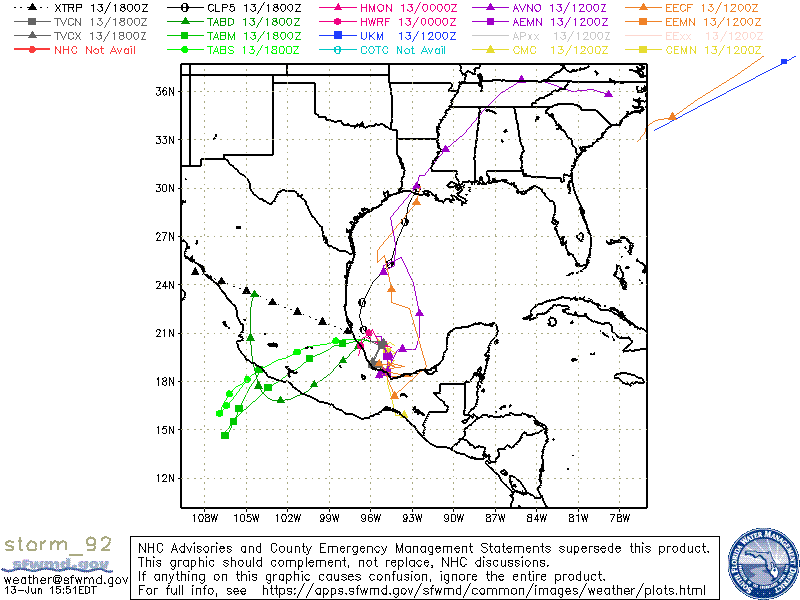
Tropical Weather Outlook NWS National Hurricane Center Miami FL 800 AM EDT Sat Jun 12 2021 For the North Atlantic...Caribbean Sea and the Gulf of Mexico: 1. An area of cloudiness and showers has developed over the Bay of Campeche and the adjacent land areas. Slow development of this system is possible over the next several days as it moves slowly and erratically, and a tropical depression could form in this area by the middle of next week. Due to the slow motion, regardless of development, heavy rainfall is possible over portions of Central America and southern Mexico. Please consult products from your local meteorological service for more information. * Formation chance through 48 hours...low...10 percent. * Formation chance through 5 days...medium...40 percent. |
|
|
|
|
|
06/13/2021 08:02 AM
|
|
|
Tropical Weather Outlook
NWS National Hurricane Center Miami FL 800 AM EDT Sun Jun 13 2021 For the North Atlantic...Caribbean Sea and the Gulf of Mexico: 1. A trough of low pressure continues to produce a large area of disorganized cloudiness and showers over the Bay of Campeche. Slow development is possible over the next several days while the broad disturbance moves little, and a tropical depression could form in this area late in the week. Regardless of development, heavy rainfall will be possible over portions of Central America and southern Mexico during the next several days. Please consult products from your local meteorological service for more information. * Formation chance through 48 hours...low...10 percent. * Formation chance through 5 days...medium...50 percent. Forecaster Blake |
|
|
|
|
|
06/13/2021 08:03 AM
|
|
|
long range shows low moving more west towards Texas coast now. But...long range...take it with a grain of salt...
|
|
|
|
|
|
06/13/2021 03:02 PM
|
|
------------------------- Dora Hates You |
|
|
|
|
|
06/14/2021 10:23 AM
|
|
|
Watching this with great hope.
------------------------- "One of the reasons why propaganda tries to get you to hate government is because it's the one existing institution in which people can participate to some extent and constrain tyrannical unaccountable power." Noam Chomsky. |
|
|
|
|
|
06/14/2021 12:51 PM
|
|
|
So far it looks like its only happening in the panhandle and its got terrible onshores.
------------------------- "One of the reasons why propaganda tries to get you to hate government is because it's the one existing institution in which people can participate to some extent and constrain tyrannical unaccountable power." Noam Chomsky. |
|
|
|
|
|
06/15/2021 12:44 PM
|
|
------------------------- Dora Hates You |
|
|
|
|
|
06/16/2021 07:04 PM
|
|
|
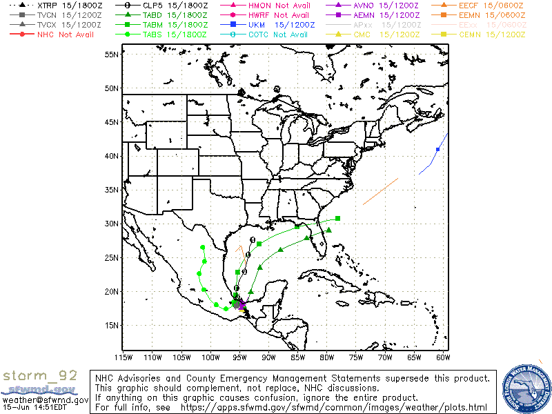
So far models keep it weak and wash out into Texas to Florida panhandle. Models don't have a good grip on it. Here we go!
Tropical Weather Outlook NWS National Hurricane Center Miami FL 800 PM EDT Wed Jun 16 2021 For the North Atlantic...Caribbean Sea and the Gulf of Mexico: 1. Shower activity associated with the broad low pressure area over the Bay of Campeche and the adjacent land areas has become a little better organized since yesterday. This system will move little tonight, and little if any development is expected during that time due to interaction with land. However, the low should begin to move northward on Thursday, and a tropical depression is likely to form by late Thursday or on Friday when the low moves across the western Gulf of Mexico. An Air Force Reserve Unit reconnaissance aircraft is scheduled to investigate the area on Thursday, if necessary. Regardless of development, heavy rainfall will continue over portions of Central America and southern Mexico during the next few days. Heavy rains should also begin to affect portions of the northern Gulf Coast on Friday. Please consult products from your local meteorological service for more information. * Formation chance through 48 hours...high...80 percent. * Formation chance through 5 days...high...90 percent. |
|
|
|
|
|
06/17/2021 04:59 AM
|
|
------------------------- Dora Hates You |
|
|
|
|
|
06/18/2021 05:11 AM
|
|
|
...
Edited: 06/18/2021 at 06:52 AM by SurferMic |
|
|
|
|
|
06/18/2021 06:20 AM
|
|
|
"Potential". Hope/Hype...
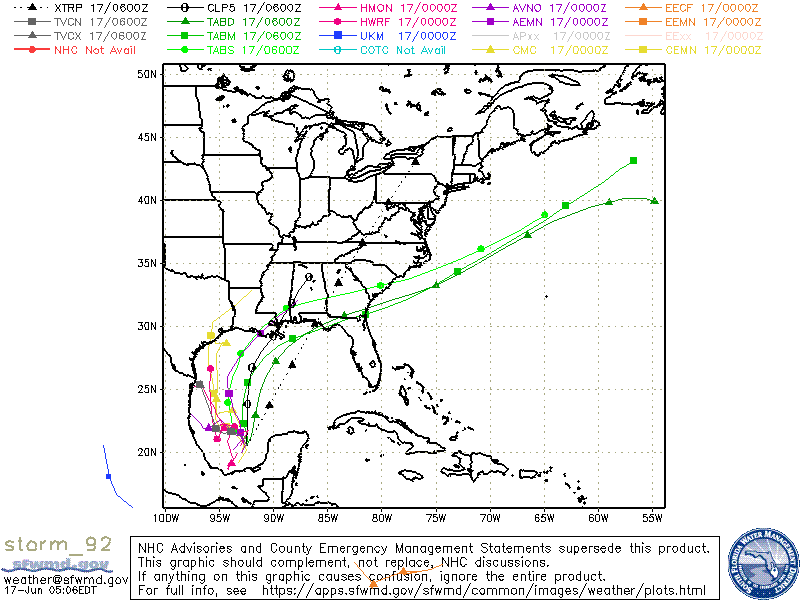
Potential Tropical Cyclone Three Discussion Number 3 NWS National Hurricane Center Miami FL AL032021 400 AM CDT Fri Jun 18 2021 The system became a little better organized overnight at the northern end of its associated broad surface trough over the central Gulf of Mexico. Satellite images show increasing deep convection along with more curvature to the low clouds, suggesting that the ill-defined center of this system is trying to re-form farther to the north. Since it still lacks a well-defined center, the system remains a potential tropical cyclone. Recent scatterometer data indicate that winds have increased to at least 30 kt and have grown over a larger area on the east side of the circulation. The initial motion is a highly uncertain 360/12. There is fair agreement that this northward motion, with some re-formation of the center, will continue as the system remains steered by a subtropical ridge to the southeast. The low should then turn northeastward and move across the southeastern U.S. No significant changes were made to the previous track forecast and the guidance is in fairly good agreement. It should also be noted that model "spaghetti" plots are not doing a good job tracking the center of this system, and could give a very misleading impression on the forecast track if used by themselves. There is still a lot of shear over the Gulf of Mexico and that should continue through landfall. However, the system is somewhat hybrid in nature and the shear shouldn't prevent its intensification to a tropical storm later today (possibly with subtropical characteristics). Model guidance is consistent with slow strengthening until landfall, and the new forecast is close to the previous one. After landfall, most of the global models show a strong band of heavy rain and tropical-storm-force winds persisting on the southeastern side. The expected large distance from the center necessitates extending the Tropical Storm Warning into the northwestern Florida panhandle. The system will likely dissipate in about 3 days over the southeastern United States. Given the current and anticipated structure of this system, users should not focus on the exact track of the center, as rainfall and wind hazards are likely to extend well east of the center and arrive well in advance of landfall. Key Messages: 1. The system is expected to produce heavy rainfall, considerable flash, urban and small stream flooding beginning today and continuing through the weekend along the Central Gulf coast with flood impacts spreading northeastward into the Southern Appalachians. 2. Tropical storm conditions are expected to begin today in areas near and well to the east of the center along portions of the central Gulf Coast from Intracoastal City, Louisiana, to the Okaloosa/Walton County line, Florida, including New Orleans. FORECAST POSITIONS AND MAX WINDS INIT 18/0900Z 25.2N 91.5W 30 KT 35 MPH...POTENTIAL TROP CYCLONE 12H 18/1800Z 27.0N 91.5W 35 KT 40 MPH...TROPICAL CYCLONE 24H 19/0600Z 29.2N 91.2W 40 KT 45 MPH 36H 19/1800Z 31.0N 89.5W 35 KT 40 MPH...INLAND 48H 20/0600Z 32.6N 87.6W 25 KT 30 MPH...INLAND 60H 20/1800Z 34.5N 85.0W 20 KT 25 MPH...POST-TROP/REMNT LOW 72H 21/0600Z...DISSIPATED |
|
|
|
|
|
06/18/2021 06:21 AM
|
|
|
There is no wind fetch pointed at Florida with this one...back to the drawing board!
https://earth.nullschool.net/#...phic=-91.60,24.73,2520 |
|
|
|
|
|
06/18/2021 06:55 AM
|
|
|
There is no wind fetch pointed at Florida with this one...back to the drawing board! Technically, the Panhandle is Florida 
------------------------- "Most people would die sooner than think; in fact, they do." - Bertrand Russell "Morality is doing what is right, regardless of what you are told. Religion is doing what you are told, regardless of what is right. If I do not answer you .... nothing personal, I just have you on ignore. |
|
|
|
|
|
06/18/2021 08:45 AM
|
|
|
|
|
|
06/19/2021 08:16 AM
|
|
|
C Name used. On to D.
Tropical Storm Claudette Advisory Number 8 NWS National Hurricane Center Miami FL AL032021 1000 AM CDT Sat Jun 19 2021 ...HEAVY RAINS AND TROPICAL-STORM-FORCE WINDS CONTINUE ALONG PORTIONS OF THE NORTHERN GULF COAST... ...TROPICAL STORM WATCH HAS BEEN ISSUED FOR A PORTION OF THE NORTH CAROLINA COAST... |
|
|
|
|
|
06/19/2021 04:21 PM
|
|
|
It's to regain Tropical Storm force winds while it's over land? That's different,
------------------------- I was right. |
|
|
|
|
|
06/20/2021 07:51 AM
|
|
|
Pensacola looks decent this morning. Not a nine hour drive worth it but decent.
------------------------- "One of the reasons why propaganda tries to get you to hate government is because it's the one existing institution in which people can participate to some extent and constrain tyrannical unaccountable power." Noam Chomsky. |
|
|
|
|
|
06/21/2021 06:56 PM
|
|
|
Tropical Storm Claudette Discussion Number 17
NWS National Hurricane Center Miami FL AL032021 500 PM EDT Mon Jun 21 2021 Claudette's low-level center passed over or near buoy 44014 (east of Virginia Beach) around 1400 UTC, and was associated with a sharp south-to-north wind shift and an estimated pressure of 1004 mb. In addition, buoy 41001, located in the southeastern quadrant of the cyclone's circulation, reported a 1-minute sustained wind of 39 kt at around 1600 UTC. Based on these data, the intensity has been increased to 40 kt, which is supported by a satellite classification of T2.5/35 kt from TAFB. The initial motion estimate is 060/25 kt. Claudette is expected to continue in a general east-northeastward direction through tonight ahead of a deep-layer trough and associated frontal system that is moving across the eastern United States. By early Tuesday, the cyclone is forecast move northeastward at a slightly faster forward speed over the colder waters of the far northwestern Atlantic. The new NHC track forecast is similar to the previous advisory track, and lies down the center of the tightly packed track model guidance suite. Claudette has likely peaked in intensity, and little change in strength is expected due to the cyclone currently moving over sub-23-deg-C sea-surface temperatures with even colder water ahead of the storm. Claudette is forecast to become a post-tropical extratropical low in the 12-24-hour period, but that transition could occur sooner. The latest official intensity forecast is similar to the previous advisory, and closely follows the intensity consensus models HCCA, FSSE, and IVCN. FORECAST POSITIONS AND MAX WINDS INIT 21/2100Z 37.5N 72.1W 40 KT 45 MPH 12H 22/0600Z 39.5N 67.9W 40 KT 45 MPH 24H 22/1800Z 42.8N 62.2W 35 KT 40 MPH...POST-TROP/EXTRATROP 36H 23/0600Z 46.0N 56.9W 35 KT 40 MPH...POST-TROP/EXTRATROP 48H 23/1800Z...DISSIPATED |
|
|
|
|
|
06/22/2021 03:46 AM
|
|
|
Some long period ticks on the Canaveral Buoy
|
|
|
|
|
|
06/22/2021 05:34 AM
|
|
|
From the ESE though. Prob one of those mystery southern hemi swells.
https://www.ndbc.noaa.gov/stat...page.php?station=41113 |
|
|
|
|
FORUMS
:
Surfing
:
Gulf Surfer's head's up for this week.
|
Topic Tools |
FuseTalk Basic Edition - © 1999-2024 FuseTalk Inc. All rights reserved.