Hey Matt B ... How the hell o are you ??? :)

2nd Light Forums
Decrease font size
Increase font size
Topic Title: Lorenzo
Topic Summary: Leave the gun...take the canoli?
Created On: 09/26/2019 08:33 AM
Linear : Threading : Single : Branch
1 2 Next Last unread
Topic Tools Topic Tools
View topic in raw text format. Print this topic.
 09/26/2019 08:33 AM
User is offline View Users Profile Print this message


Plan B

Posts: 3302
Joined Forum: 03/08/2004

FAR away.... but FIRED up. Should send some big enough swell to handle decay over that distance, and still have some solid long period punch. Unfortunately as Karen (or her remnants ) approach, it should increase the pressure gradient between the ridge and the onshore winds in the process.... hopefully we luck out with one solid (semi clean) day ..... Hopefully it slows down some, to keep swell in the water that outlasts the onshores.....The wrist is almost ready
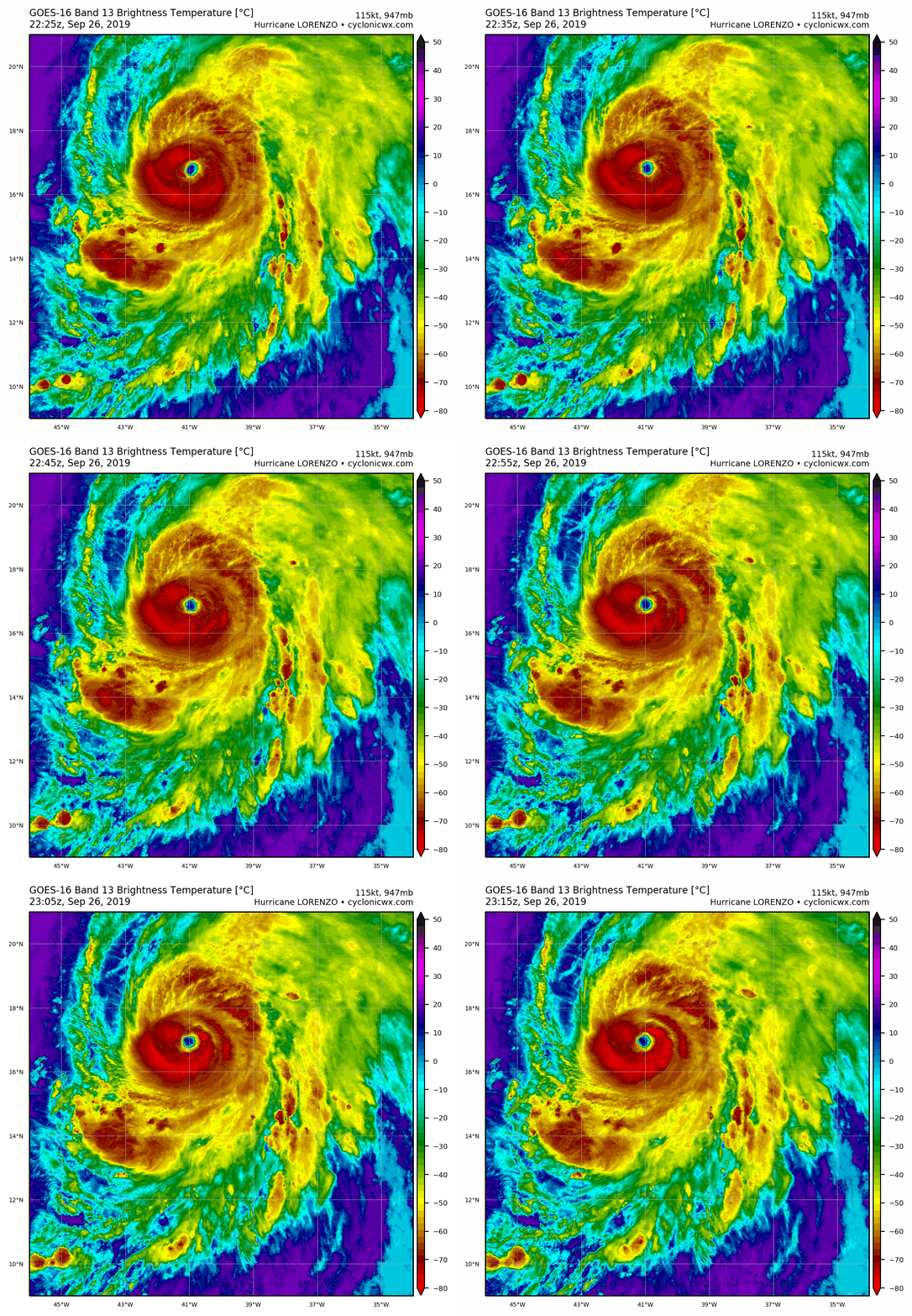
A review of microwave satellite imagery from last night suggests that Lorenzo underwent an eyewall replacement cycle, with the outer eyewall becoming predominant around 06Z-09Z. Around that time, the hurricane started to rapidly intensify, with the eye becoming much better defined in conventional satellite imagery. Raw Data-T numbers from both subjective and objective versions of the Dvorak Technique suggest that the maximum winds have increased to near 115 kt, which will be the initial intensity for this advisory. The initial wind radii have been revised based on a recently received scatterometer overpass.
FORECAST POSITIONS AND MAX WINDS INIT 26/1500Z 15.4N 40.2W 115 KT 130 MPH 12H 27/0000Z 16.7N 41.4W 125 KT 145 MPH 24H 27/1200Z 18.5N 42.6W 125 KT 145 MPH 36H 28/0000Z 20.2N 43.5W 120 KT 140 MPH 48H 28/1200Z 21.9N 43.9W 110 KT 125 MPH 72H 29/1200Z 25.2N 43.3W 100 KT 115 MPH 96H 30/1200Z 29.0N 41.0W 100 KT 115 MPH 120H 01/1200Z 34.0N 37.0W 90 KT 105 MPH
Data from the SHIPS model suggest that Lorenzo will be in an area of maximum potential intensities of 125-135 kt for the next 3-4 days. This suggests that the rapid intensification should end in the next 6-12 h as the actual intensity approaches those speeds. Fluctuations in strength due to eyewall replacement cycles are expected during the 12-36 h period. The global models suggest that Lorenzo will subsequently interact with an upper-level trough during recurvature, which should cause a period of increased shear and some weakening of the cyclone around 48 h. By 120 h, the hurricane should weaken due to movement over colder water and into strong shear in the mid-latitude westerlies. While its exact ranking will be determined later, Lorenzo is one of the largest and most powerful hurricanes of record for the central tropical Atlantic, with the only comparable hurricane in recent times near there being Gabrielle of 1989.
sorry about the shitty paragraphs.... not sure why it does that

Edited: 09/26/2019 at 08:34 AM by Plan B
 09/26/2019 09:22 AM
User is offline View Users Profile Print this message


daner

Posts: 7918
Joined Forum: 04/20/2004

timing... Its about 2,000 miles away with swell traveling at 20 mph should take 100 hours or 4 days to get here. From Sunday that means Thursday/Friday for peak swell. Does that sound right? Hopefully winds die down by then.

-------------------------
Replace turf grass with native plants that don't need irrigation and synthetic fertilizers or chemicals that can go into our waterways and ocean

 09/26/2019 10:29 AM
User is offline View Users Profile Print this message


mp2115

Posts: 174
Joined Forum: 05/29/2009

Florida the place of hope and dreams.
 09/26/2019 10:38 AM
User is offline View Users Profile Print this message


Plan B

Posts: 3302
Joined Forum: 03/08/2004

Originally posted by: daner timing... Its about 2,000 miles away with swell traveling at 20 mph should take 100 hours or 4 days to get here. From Sunday that means Thursday/Friday for peak swell. Does that sound right? Hopefully winds die down by then.
Yeah, pretty close.... although it always seems to show up a day earlier than you'd think... I wish it had more of a westerly push before making that hook. At the speed it's moving, once it makes that hook, the swell potential drops like a rock.... but it does have a broad windfield....
 09/26/2019 10:59 AM
User is offline View Users Profile Print this message


daner

Posts: 7918
Joined Forum: 04/20/2004

Thanks Plan B for checking it. Yea, I was looking at peak swell since Sun/Mon is when it's most in our swell window and a major hurricance. But based on it's locations Fri/Sat we should start seeing precursors on Monday I think.

-------------------------
Replace turf grass with native plants that don't need irrigation and synthetic fertilizers or chemicals that can go into our waterways and ocean

 09/26/2019 11:13 AM
User is offline View Users Profile Print this message


Plan B

Posts: 3302
Joined Forum: 03/08/2004

agreed... but I wouldnt be surprised if there was some mini swell showing up on sunday..... underneath the windchop
 09/26/2019 11:24 AM
User is offline View Users Profile Print this message


Plan B

Posts: 3302
Joined Forum: 03/08/2004

Beast
 09/26/2019 12:52 PM
User is offline View Users Profile Print this message


rc

Posts: 1147
Joined Forum: 01/02/2006

41009

Virtual buoy showing huge interval spike on Sunday, so some early arrivers.
 09/26/2019 01:49 PM
User is offline View Users Profile Print this message


foam ball

Posts: 1819
Joined Forum: 06/01/2005

Just in time for NE wind at 15-25 Mon - Wed
 09/26/2019 02:21 PM
User is offline View Users Profile Print this message


SurferMic

Posts: 1251
Joined Forum: 06/30/2012

Embrace the off shores, it is Florida and West winds with waves is a rare event...Hey **Daner** see you at the On shore spot Monday AM or PM? Tuesday AM?.... not sure if there will be enough size but worth a look , maybe end up North of the bridge , just looking for a short paddle out and punchy sets.

Edited: 09/26/2019 at 02:23 PM by SurferMic
 09/26/2019 02:42 PM
User is offline View Users Profile Print this message


Cole

Posts: 68176
Joined Forum: 07/22/2003

Plenty of swell in the water right now, but the bars are blowing.

It's an easy three feet, I checked four spots and I'm sitting here typing, not surfing.

-------------------------
I was right.
 09/26/2019 04:35 PM
User is offline View Users Profile Print this message


Plan B

Posts: 3302
Joined Forum: 03/08/2004

Originally posted by: daner I was looking at peak swell since Sun/Mon is when it's most in our swell window
Actually per forecast track, I'd say peak swell comes from today-sat.... once it makes that hook....ehhhh... As far as offshores, the surf is way better down by you guys today. It was good here tues. I tested the wrist, and didnt go. been feeling better each day though.... To miss all these waves after a FLAT summer (and shitty year overall) has me jonesin' These hurricane maps make me feel like a 13 year old kid with a Playboy anyway... Lorenzo:

Edited: 09/26/2019 at 04:36 PM by Plan B
 09/27/2019 03:40 PM
User is offline View Users Profile Print this message


Cole

Posts: 68176
Joined Forum: 07/22/2003

Ireland might take it on the head.

http://www.stormsurfing.com/cg...lay.cgi?a=natla_height

-------------------------
I was right.
 09/28/2019 07:21 AM
User is offline View Users Profile Print this message


Central Floridave

Posts: 52249
Joined Forum: 07/22/2003

Gigantic swell forecast for Western Europe surf spots!
 09/28/2019 08:34 AM
User is online View Users Profile Print this message


dingpatch

Posts: 19032
Joined Forum: 07/24/2003

Time to dust-off your hood, booties and 5/4, and get to the airport, , , , ,

-------------------------
Dora Hates You
 09/28/2019 11:38 AM
User is offline View Users Profile Print this message


ww

Posts: 16088
Joined Forum: 08/17/2007

Checked Google Flights. Seems you can book a week visit to Lisbon from Orlando, leaving tomorrow for $868 with kiwi.com.
 09/28/2019 06:02 PM
User is offline View Users Profile Print this message


RocketSurf

Posts: 645
Joined Forum: 03/20/2014

Dissection of open ocean swells......

http://www.stormsurf.com/page2...rials/wavebasics.shtml

"The speed (in nautical miles per hour or kts) of an individual deep water wave is about 3 times it's period (in seconds). That is, an individual wave with a 13 second period travels at 39 kts. Contrary to what you might intuitively think, there is a linear relationship between wave period and wave speed. But because most deep water waves move in groups, the group speed is half that of an individual wave (within the group), or in this example about 19.5 kts. As the wave moves into shallow water, the group speed and the individual wave speed become the same, so the individual wave starts traveling at the group speed, or 19.5 kts. This wave speed formula is approximate, and actually wave speeds are a fraction different, but this is close enough for all but the most detailed surf forecaster."
 09/29/2019 01:02 AM
User is offline View Users Profile Print this message


ww

Posts: 16088
Joined Forum: 08/17/2007

Very interesting coastal flood watch from National Weather Service. 17 sec swell. Interesting possibility for Vero's South Beach. Brevard beaches with relatively gentle slopes tend to have spilling waves (not always, of course). South Beach is relatively steep due to lots of shell fragments, so almost always is "plunging," waves with lips. A really steep beach or some other factor can cause plunging to morph into surging, where the water just pushes up the beach with no breaking wave. I've seen that once at South Beach, on what was a big day with a swell, elsewhere. South Beach merely had water coming and going.
 09/29/2019 07:10 AM
User is offline View Users Profile Print this message


Plan B

Posts: 3302
Joined Forum: 03/08/2004

Cant believe this BEAST hit Cat5 last night with 160mph sustained...... NEVER before has one that far east (and north) ever done that..... Climate change? nahhhhhh I just wish he'd stall out for a bit.... for our surf, and for the Azores/Europe.
 09/29/2019 07:21 AM
User is offline View Users Profile Print this message


daner

Posts: 7918
Joined Forum: 04/20/2004

Fake news.

-------------------------
Replace turf grass with native plants that don't need irrigation and synthetic fertilizers or chemicals that can go into our waterways and ocean

FORUMS : Surfing : Lorenzo

1 2 Next Last unread
Topic Tools Topic Tools
Statistics
146494 users are registered to the 2nd Light Forums forum.
There are currently 4 users logged in to the forum.

FuseTalk Basic Edition - © 1999-2024 FuseTalk Inc. All rights reserved.

First there was Air Jordan .