
 |
2nd Light Forums |
 |
 |  |


|
Topic Title: TROPICAL DEPRESSION TEN Edit: Now TS JERRY Topic Summary: Next batter up...tracking looks towards us and as Hurricane Created On: 09/17/2019 07:57 AM |
Linear : Threading : Single : Branch |
|
 Topic Tools Topic Tools
|

 09/17/2019 07:57 AM 09/17/2019 07:57 AM


|
|
|
Since the depression is still in the development phase, the initial
motion is a somewhat uncertain 295/10 kt. A strong deep-layer ridge to the north of the cyclone should steer the depression generally west-northwestward at a faster forward speed during the next few days. The track guidance is in relatively good agreement through 72 hours, and brings the cyclone near the northern Leeward Islands in about 3 days. By late in the period, the cyclone is expected to reach the western periphery of the ridge, and there is increasing spread among the guidance. The global model ensemble means are along the right side of the envelope while the HWRF and UKMET are along the left side. The NHC track lies close the consensus aids, which is also in good agreement with the latest ECMWF. Interests in the northern Leeward Islands should monitor the progress of this system. FORECAST POSITIONS AND MAX WINDS INIT 17/1500Z 12.9N 44.9W 30 KT 35 MPH 12H 18/0000Z 13.8N 46.1W 35 KT 40 MPH 24H 18/1200Z 14.7N 47.9W 40 KT 45 MPH 36H 19/0000Z 15.5N 50.2W 45 KT 50 MPH 48H 19/1200Z 16.3N 52.9W 55 KT 65 MPH 72H 20/1200Z 18.2N 59.2W 65 KT 75 MPH 96H 21/1200Z 20.2N 64.7W 75 KT 85 MPH 120H 22/1200Z 22.5N 69.0W 80 KT 90 MPH Edited: 09/18/2019 at 04:45 AM by Central Floridave |
|
|
|
|
|
09/17/2019 08:00 AM
|
|
|
Sunday (sep 22).....22.5N 69.0W ----> North of Dominican Republic SE of the Bahamas. Another potential swell maker.
|
|
|
|
|
|
09/17/2019 08:31 AM
|
|
|
Maybe this will finally be what we've been waiting for since Joaqin. Trying to not get my hopes up but the epic swell dry spell cant last forever either
Edited: 09/17/2019 at 08:38 AM by Julianuribe23 |
|
|
|
|
|
09/17/2019 08:49 AM
|
|
|
Another week for my wrist to heal.... hopefully it slows way down
|
|
|
|
|
|
09/17/2019 10:58 AM
|
|
|
European model (as seen at Windy) is showing a pretty wimpy storm
|
|
|
|
|
|
09/17/2019 01:08 PM
|
|
|
|
|
|
|
|
|
09/17/2019 03:37 PM
|
|
|
NHC named Imelda in Western Gulf, thus TD Ten won't be named Imelda.
|
|
|
|
|
|
09/17/2019 06:27 PM
|
|
|
Just stay offshore, storm.. |
|
|
|
|
|
09/18/2019 04:45 AM
|
|
|
1. Jerry is expected to strengthen and be a hurricane when
its moves near the northern Leeward Islands Friday, although it is too soon to determine if there will be any direct impacts in the islands. Interests there should ensure they have their hurricane plan in place and monitor the progress of this system. FORECAST POSITIONS AND MAX WINDS INIT 18/0900Z 14.1N 47.7W 40 KT 45 MPH 12H 18/1800Z 14.8N 49.4W 45 KT 50 MPH 24H 19/0600Z 15.7N 52.0W 55 KT 65 MPH 36H 19/1800Z 16.8N 54.9W 60 KT 70 MPH 48H 20/0600Z 17.9N 57.9W 65 KT 75 MPH 72H 21/0600Z 20.2N 64.2W 65 KT 75 MPH 96H 22/0600Z 22.8N 68.6W 65 KT 75 MPH 120H 23/0600Z 25.6N 70.2W 65 KT 75 MPH |
|
|
|
|
|
09/18/2019 12:23 PM
|
|
|
|
|
|
|
|
|
09/18/2019 12:38 PM
|
|

|
|
|
|
|
|
09/18/2019 07:16 PM
|
|
|
I definitely like that north curve. But seems like it will be quite far off and weak. would we even see anything from Jerry? |
|
|
|
|
|
09/18/2019 07:51 PM
|
|
|
Kramer is next storm....after Jerry?
|
|
|
|
|
|
09/20/2019 07:55 AM
|
|
|
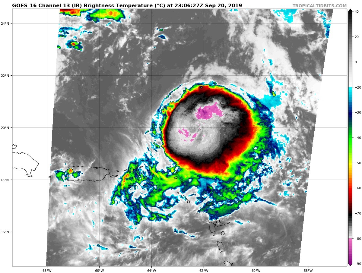
Looks like Jerry is losing his mojo....
|
|
|
|
|
|
09/20/2019 08:04 AM
|
|
|
"While yesterday much of the guidance had
Jerry accelerating ahead of the trough, today's models have slowed
everything down as the trough looks like it could weaken before
fully recurving the cyclone. The new track forecast is considerably
slower than the last one beyond 72 hours, about as much as
continuity allows, and later forecasts could slow Jerry down even
more."
Weakening trend I don't like but slowing down I do. A hurricane Leslie scenario would be nice.
------------------------- Heavy is sign of reliability |
|
|
|
|
|
09/20/2019 08:19 AM
|
|
|
Hurricane Jerry Discussion Number 13
NWS National Hurricane Center Miami FL AL102019 1100 AM AST Fri Sep 20 2019 Data from both NOAA and Air Force Reserve Hurricane Hunter aircraft indicate that Jerry is weakening quickly, and radar images from NOAA show no sign of the eyewall reported on the last mission. Maximum flight-level winds on the mission were about 78 kt, with SFMR values near 70 kt, and the central pressure has risen about 10 mb overnight. These observations also agree with the latest satellite imagery that shows a less organized cyclone, with the center on the far northwestern edge of a distorted central dense overcast. A blend of all these data gives an initial wind speed estimate of 75 kt. Jerry is moving about the same as before, west-northwestward at 15 kt. The hurricane should gradually bend to the right and slow down during the next few days while the cyclone is steered around the western periphery of a weakening subtropical ridge. The guidance is tightly packed on the forecast through Monday, and little change was made to the previous NHC prediction. At longer range, a mid-latitude trough interaction should turn the hurricane northward and northeastward, but the models are really struggling on how quickly this occurs. While yesterday much of the guidance had Jerry accelerating ahead of the trough, today's models have slowed everything down as the trough looks like it could weaken before fully recurving the cyclone. The new track forecast is considerably slower than the last one beyond 72 hours, about as much as continuity allows, and later forecasts could slow Jerry down even more. Northwesterly shear is forecast to persist near Jerry for the next day or two, and some weakening is expected. The intensity forecast is reduced from the previous one, and could be a bit too high in the short term given recent trends. In a few days, the aforementioned trough interaction is anticipated, but it is next to impossible to know at this lead time whether the trough will weaken or strengthen the cyclone, so no forecast change is made. It is a little tempting to raise the intensity by the end, given the recent weaker mid-latitude trough in the models, but there's just too much track uncertainty to mess with the intensity forecast at this time. Key Messages: 1. Although the core of Jerry is expected to move north of the northern Leeward Islands, heavy rainfall and flash floods are possible there today. FORECAST POSITIONS AND MAX WINDS INIT 20/1500Z 18.8N 60.3W 75 KT 85 MPH 12H 21/0000Z 19.6N 62.4W 70 KT 80 MPH 24H 21/1200Z 20.9N 64.7W 65 KT 75 MPH 36H 22/0000Z 22.3N 66.6W 60 KT 70 MPH 48H 22/1200Z 23.6N 68.0W 60 KT 70 MPH 72H 23/1200Z 26.5N 69.0W 65 KT 75 MPH 96H 24/1200Z 29.0N 67.5W 65 KT 75 MPH 120H 25/1200Z 33.0N 64.0W 65 KT 75 MPH |
|
|
|
|
|
09/20/2019 08:22 AM
|
|
|
virtual buoy models show small long period swell for sunday thru tuesday. However, its probably going to get masked by the onshore wind swell.
Hopefully the local wind forecast is wrong for Jerry swell. But...welcome to life of a Florida surfer! |
|
|
|
|
|
09/20/2019 08:28 AM
|
|
|
He can't go left...
|
|
|
|
|
|
09/20/2019 09:50 AM
|
|
|
At least every spot from OBX to Nova Scotia will be offshore this weekend. Happy for them

Edited: 09/20/2019 at 09:57 AM by Greensleeves |
|
|
|
|
|
09/20/2019 04:15 PM
|
|
|
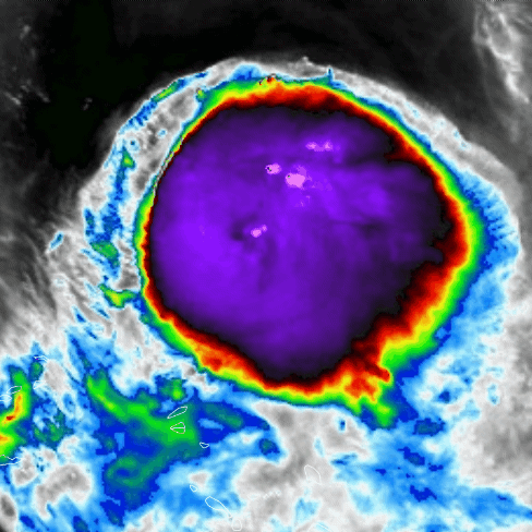
rut roh... looks like Jerry doesnt want to get off the stage yet...
|
|
|
|
|
FORUMS
:
Surfing
:
TROPICAL DEPRESSION TEN Edit: Now TS JERRY
|
Topic Tools |
FuseTalk Basic Edition - © 1999-2024 FuseTalk Inc. All rights reserved.