
 |
2nd Light Forums |
 |
 |  |


|
Topic Title: The Next Hope or Hype Topic Summary: Created On: 08/03/2017 01:09 PM |
Linear : Threading : Single : Branch |
|
 Topic Tools Topic Tools
|

 08/12/2017 12:47 PM 08/12/2017 12:47 PM


|
|
|
|
|
|
08/12/2017 02:04 PM
|
|
|
Tropical Weather Outlook
NWS National Hurricane Center Miami FL 200 PM EDT Sat Aug 12 2017 For the North Atlantic...Caribbean Sea and the Gulf of Mexico: 1. The area of disturbed weather associated with a low pressure system located a couple of hundred miles northeast of the Turks and Caicos Islands continues to show some signs of organization, but there is no evidence of a closed surface circulation. Conditions remain conducive for development, and a tropical depression could form during the next day or two. The low is forecast to move northwestward and northward through the weekend, and then turn to the northeast away from the United States early next week. * Formation chance through 48 hours...medium...60 percent. * Formation chance through 5 days...high...70 percent. |
|
|
|
|
|
08/12/2017 09:32 PM
|
|
|
Finally 99L made something of itself, just 600miles off our coast
still though, The strongest winds are on the east side which is not pointed at us, Still think we will get at least waist high, maybe chest swell Monday with light winds. Might last longer now if this expands, it's not moving all that fast.
Should we start talking about the next one? lol We would get so many more swells if the GFS came true!
Actually the canadian is worse than the GFS when it comes to tropical systems. But man if it came true once in a while we would get a heck of a swell
------------------------- WPTV NewsChannel5/Fox 29 Snapchat: Surfnweatherman Edited: 08/12/2017 at 09:39 PM by jwieland |
|
|
|
|
|
08/13/2017 05:10 AM
|
|
|
The CMC (C.reating M.ultiple C.yclones) Also looks like the EURO is starting to hop on that next wave (satelittle is impressive)... and I'm supposed to go out of town next sun-tues and have yet to finish fixing my house from Matthew so........ any back to TD8... moving NNW 14 is too fast given the aasymetrical fetch direction. I agree on your assesment of the surf size based on the offshore buoys. Prob waist to chest tomorrow morn.... and may be bigger up here than CFL south. Buoy 47 is 7'@ 8 sec..... so prob cut that down to maybe 3@9 when it gets here? |
|
|
|
|
|
08/13/2017 05:15 AM
|
|
|
All I know I'm glad I've been swimming 1/4 mile a day, or at least trying to. Bigger surf is gonna happen eventually.
The north bahama buoy looks interesting now (Sunday morning). Up to 7 feet from ESE. Something should trickle in on Monday from that. http://www.ndbc.noaa.gov/station_page.php?station=41047 |
|
|
|
|
|
08/13/2017 05:22 AM
|
|
|
815am eyeball viz: Something is trickling in right now....
------------------------- So if you are a surfer I wish you the prosperity that allows you more time to pursue the salt water dream, and the true happiness that comes from warm water, clean waves and the companionship of your fellow surfers. If you are an internet troll just spewing bs then f off. |
|
|
|
|
|
08/13/2017 05:32 AM
|
|
|
Thanks. Maybe a good time to blow the dust off the board! LOL, I've been surfing but so ready for bigger surf. Yeah for both school, football, AND, hurricane season for kicking off! Mosquito season is in full effect also so the next hope/hype wish will be a cold front.
|
|
|
|
|
|
08/13/2017 10:04 AM
|
|
|
NWS National Hurricane Center Miami FL AL082017
1100 AM EDT Sun Aug 13 2017 ...DEPRESSION FORECAST TO BECOME A TROPICAL STORM LATER TODAY OR TONIGHT... SUMMARY OF 1100 AM EDT...1500 UTC...INFORMATION ----------------------------------------------- LOCATION...27.4N 71.5W ABOUT 525 MI...845 KM SW OF BERMUDA MAXIMUM SUSTAINED WINDS...35 MPH...55 KM/H PRESENT MOVEMENT...NNW OR 335 DEGREES AT 13 MPH...20 KM/H MINIMUM CENTRAL PRESSURE...1011 MB...29.86 INCHES WATCHES AND WARNINGS -------------------- There are no coastal watches or warnings in effect. DISCUSSION AND 48-HOUR OUTLOOK ------------------------------ At 1100 AM EDT (1500 UTC), the center of Tropical Depression Eight was located near latitude 27.4 North, longitude 71.5 West. The depression is moving toward the north-northwest near 13 mph (20 km/h) and this general motion is expected to continue through today. A turn toward the north is forecast to occur tonight, followed by a turn toward the north-northeast on Monday. Maximum sustained winds are near 35 mph (55 km/h) with higher gusts. Gradual strengthening is expected during the next 48 hours, and the depression is forecast to become a tropical storm later today or tonight. The minimum central pressure estimated from reports from a NOAA buoy is 1011 mb (29.86 inches). |
|
|
|
|
|
08/13/2017 11:38 AM
|
|
|
Very fun day Sunday on the log.
------------------------- "One of the reasons why propaganda tries to get you to hate government is because it's the one existing institution in which people can participate to some extent and constrain tyrannical unaccountable power." Noam Chomsky. |
|
|
|
|
|
08/13/2017 01:41 PM
|
|
|
The winds aren't gaining too much strength, but it's rapidly increasing surface area...which hopefully increases the size of the wind field.
http://www.accuweather.com/en/...ane/atlantic/satellite ------------------------- I was right. |
|
|
|
|
|
08/13/2017 01:47 PM
|
|
|
Wind forecast.
http://www.windfinder.com/forecast/cocoa_beach With any luck some swell shows up tomorrow. ------------------------- I was right. |
|
|
|
|
|
08/13/2017 03:31 PM
|
|
|
NWS National Hurricane Center Miami FL AL082017
500 PM EDT Sun Aug 13 2017 ...DEPRESSION STRENGTHENS TO TROPICAL STORM GERT... |
|
|
|
|
|
08/13/2017 03:57 PM
|
|
|
....Maybe a good time to blow the dust off the board! LOL, I've been surfing but so ready for bigger surf.... I'm with ya Dave! Wondering if/ when I'll get to ride my shortboard as the board of choice.... ------------------------- Time and tide wait for no one..... |
|
|
|
|
|
08/13/2017 04:17 PM
|
|
|
|
|
|
|
|
|
08/14/2017 04:22 PM
|
|
|
Tropical Storm Gert Advisory Number 8
NWS National Hurricane Center Miami FL AL082017 500 PM EDT Mon Aug 14 2017 ...GERT CONTINUES TO STRENGTHEN... ...EXPECTED TO BECOME A HURRICANE TONIGHT... |
|
|
|
|
|
08/15/2017 08:04 AM
|
|
|
Gert made hurricane strength...but bye bye Gert! So, it was hope to hype to hope to hype to back to hope...
Hurricane Gert Advisory Number 11 NWS National Hurricane Center Miami FL AL082017 1100 AM EDT Tue Aug 15 2017 ...GERT BEGINS ITS TURN TOWARD THE NORTHEAST... |
|
|
|
|
|
08/15/2017 01:59 PM
|
|
|
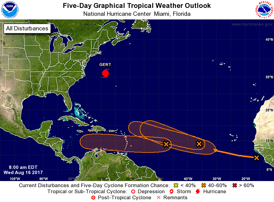
Looks like there is a parade of red blobs coming out of Africa.
------------------------- So if you are a surfer I wish you the prosperity that allows you more time to pursue the salt water dream, and the true happiness that comes from warm water, clean waves and the companionship of your fellow surfers. If you are an internet troll just spewing bs then f off. |
|
|
|
|
|
08/16/2017 05:17 AM
|
|
|
08/16/2017 05:34 AM
|
|
|
Place ya bets.... step right up and place ya bets...
|
|
|
|
|
|
08/16/2017 06:39 AM
|
|
|
Our odds are increasing.
------------------------- "One of the reasons why propaganda tries to get you to hate government is because it's the one existing institution in which people can participate to some extent and constrain tyrannical unaccountable power." Noam Chomsky. |
|
|
|
|


FORUMS
:
Surfing
:
The Next Hope or Hype
|
Topic Tools |
FuseTalk Basic Edition - © 1999-2024 FuseTalk Inc. All rights reserved.