
 |
2nd Light Forums |
 |
 |  |


|
Topic Title: tropics NHC waking up Topic Summary: couple possible systems on NHC afternoon outlook Created On: 06/16/2017 12:04 PM |
Linear : Threading : Single : Branch |
 Topic Tools Topic Tools
|

 06/16/2017 12:04 PM 06/16/2017 12:04 PM


|
|
|
If that system moves up into the Gulf we will probably see stronger SE wind swell than what has been forecast early next week.
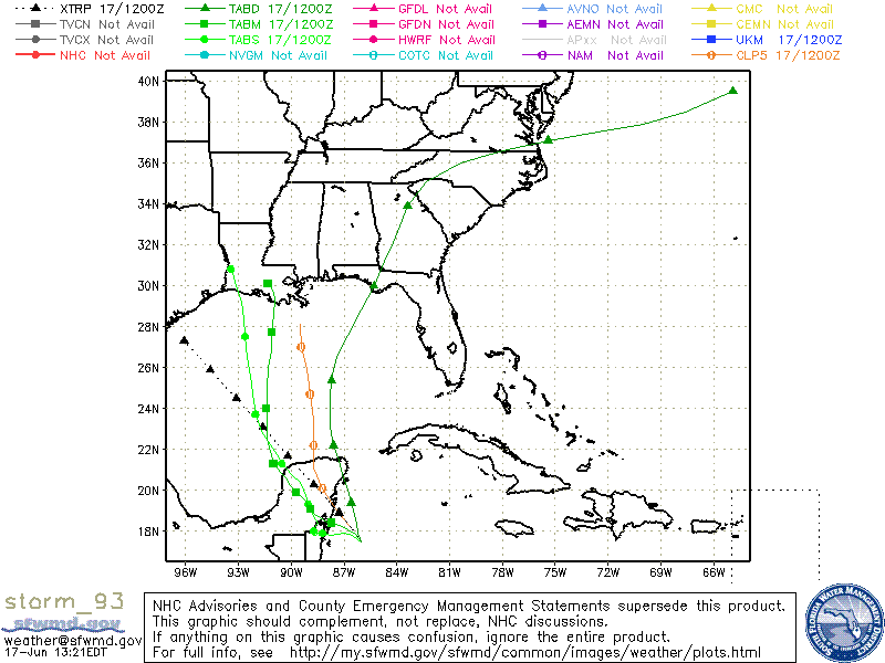
Tropical Weather Outlook NWS National Hurricane Center Miami FL 200 PM EDT Fri Jun 16 2017 For the North Atlantic...Caribbean Sea and the Gulf of Mexico: 1. Cloudiness and showers associated with a tropical wave located several hundred miles southwest of the Cabo Verde Islands continue to show signs of organization. Slow development is possible during the next few days while the wave moves westward at 15-20 mph over the tropical Atlantic. * Formation chance through 48 hours...low...30 percent. * Formation chance through 5 days...medium...50 percent. 2. A large area of disturbed weather has formed over the western Caribbean Sea and the adjacent portions of Central America. Conditions appear to be favorable for gradual development of this system while it moves slowly northwestward across the Yucatan Peninsula this weekend and into the southern and central Gulf of Mexico early next week. Regardless of development, heavy rains are likely to spread over portions of Central America and the Yucatan Peninsula during the next several days. * Formation chance through 48 hours...low...10 percent. * Formation chance through 5 days...medium...60 percent. Forecaster Beven |
|
|
|
|
|
06/16/2017 12:53 PM
|
|
|
Thanks for sharing & WOW that's early for cape verde storm... ------------------------- get up early and go surf - it'll make that hangover go away and/or make the workday more tolerable :) |
|
|
|
|
|
06/16/2017 02:39 PM
|
|
|
Best shot is from the Crib storm , the GFS has it moving central to NE Gulf next week , while the Euro has it moving toward northern mexico . The GFS has been in the crapper lately so who knows
|
|
|
|
|
|
06/17/2017 07:57 AM
|
|
|
Tropical Weather Outlook
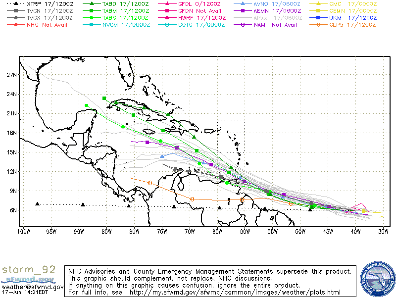
NWS National Hurricane Center Miami FL 800 AM EDT Sat Jun 17 2017 For the North Atlantic...Caribbean Sea and the Gulf of Mexico: 1. A tropical wave located about 1500 miles east-southeast of the southern Windward Islands is producing scattered showers and thunderstorms. This disturbance has changed little in organization since yesterday. However, some development is expected during the next few days before conditions become less favorable for tropical cyclone formation. This system is expected to continue moving toward the west or west-northwest at 15 to 20 mph over the tropical Atlantic during the next several days. * Formation chance through 48 hours...medium...40 percent. * Formation chance through 5 days...high...70 percent. 2. A broad trough of low pressure is producing a large area of cloudiness and showers over the northwestern Caribbean Sea and the adjacent land areas. Conditions appear to be favorable for gradual development of this large disturbance while it moves slowly northwestward across the Yucatan Peninsula this weekend, and a tropical cyclone could form early next week over the southern or central Gulf of Mexico. Regardless of development, heavy rains are likely to spread over portions of Central America, the Yucatan Peninsula, Jamaica, the Cayman Islands, and western Cuba during the next several days. * Formation chance through 48 hours...low...20 percent. * Formation chance through 5 days...high...70 percent. Forecaster Beven |
|
|
|
|
|
06/17/2017 11:29 AM
|
|
------------------------- Dora Hates You |
|
|
|
|
|
06/17/2017 11:30 AM
|
|
------------------------- Dora Hates You |
|
|
|
|
|
06/17/2017 06:35 PM
|
|
|
Maybe we'll get some side effects from all the activity. NOAA has increased the wave forecast for this week.
------------------------- Replace turf grass with native plants that don't need irrigation and synthetic fertilizers or chemicals that can go into our waterways and ocean |
|
|
|
|
|
06/17/2017 07:25 PM
|
|
|
another big flare up moved off of Africa a couple of days ago and is following up behind this one. looking interesting , may not have to wait as long this summer for some action
|
|
|
|
|
|
06/17/2017 11:20 PM
|
|
|
one thing ive learned.. these storms that take the low road near south america and strengthen up are more likely to affect florida. anything north of the low road is a swingout to the north. little early for anything to come near us but the low road is definitely the road we have to watch out for. |
|
|
|
|
|
06/19/2017 05:59 PM
|
|
|
BULLETIN
Tropical Storm Bret Intermediate Advisory Number 5A NWS National Hurricane Center Miami FL AL022017 800 PM AST Mon Jun 19 2017 ...HEAVY RAIN BANDS SPREADING ACROSS TRINIDAD AND TOBAGO... SUMMARY OF 800 PM AST...0000 UTC...INFORMATION ---------------------------------------------- LOCATION...9.5N 60.5W ABOUT 85 MI...135 KM SE OF TRINIDAD ABOUT 195 MI...315 KM SSE OF GRENADA MAXIMUM SUSTAINED WINDS...40 MPH...65 KM/H PRESENT MOVEMENT...WNW OR 280 DEGREES AT 25 MPH...40 KM/H MINIMUM CENTRAL PRESSURE...1008 MB...29.76 INCHES DISCUSSION AND 48-HOUR OUTLOOK ------------------------------ At 800 PM AST (0000 UTC), the center of Tropical Storm Bret was located near latitude 9.5 North, longitude 60.5 West. Bret is moving toward the west-northwest near 25 mph (40 km/h) and is expected to slow down over the next 48 hours. On the forecast track, the tropical storm is expected to move near or over Trinidad and the eastern coast of Venezuela tonight and early Tuesday. Maximum sustained winds are near 40 mph (65 km/h) with higher gusts. Little change in strength is forecast during the next 12 to 24 hours. A weakening trend is forecast to begin on Wednesday and Bret is expected to become a tropical depression. Tropical-storm-force winds extend outward up to 80 miles (130 km) from the center, mainly north of the center. The estimated minimum central pressure is 1008 mb (29.76 inches). $$ Forecaster Roberts |
|
|
|
|
|
06/19/2017 06:01 PM
|
|
|
Tropical Storm Bret is in the Caribbean.
The one in the Gulf looks to possibly be named soon also. |
|
|
|
|
|
06/19/2017 06:02 PM
|
|
|
Potential Tropical Cyclone Three Intermediate Advisory Number 1A
NWS National Hurricane Center Miami FL AL032017 700 PM CDT Mon Jun 19 2017 ...DISTURBANCE STATIONARY OVER THE CENTRAL GULF OF MEXICO... SUMMARY OF 700 PM CDT...0000 UTC...INFORMATION ---------------------------------------------- LOCATION...24.0N 89.2W ABOUT 350 MI...560 KM S OF THE MOUTH OF THE MISSISSIPPI RIVER ABOUT 415 MI...670 KM SSE OF MORGAN CITY LOUISIANA MAXIMUM SUSTAINED WINDS...40 MPH...65 KM/H PRESENT MOVEMENT...STATIONARY MINIMUM CENTRAL PRESSURE...1000 MB...29.53 INCHES DISCUSSION AND 48-HOUR OUTLOOK ------------------------------ At 700 PM CDT (0000 UTC), the disturbance was centered near latitude 24.0 North, longitude 89.2 West. The system has been stationary during the past few hours. However, a motion toward the north-northwest is expected to resume later tonight, followed by a turn toward the northwest on Tuesday and Tuesday night. On the forecast track, the disturbance will move toward the Louisiana coast on Tuesday and Wednesday. Maximum sustained winds are near 40 mph (65 km/h) with higher gusts. Some slight strengthening is possible before the system reaches the coast. Upper-level winds are expected to be marginally conducive for some additional development of this system during the next day or two, and a tropical or subtropical cyclone is likely to form during that time. * Formation chance through 48 hours...high...80 percent * Formation chance through 5 days...high...80 percent Tropical-storm-force winds extend outward up to 205 miles (335 km) to the north and east of the center. The estimated minimum central pressure based on reports from reconnaissance aircraft and nearby ships is 1000 mb (29.53 inches). |
|
|
|
|
|
06/20/2017 07:04 AM
|
|
|
Tropical Storm Bret is in the Caribbean. The one in the Gulf looks to possibly be named soon also. Accuweather: "The system strengthened into Tropical Storm Bret on Monday afternoon. Since Bret formed prior to June 22, it has become the earliest named storm to form in this part of the Atlantic since official records were kept in 1851." ------------------------- Replace turf grass with native plants that don't need irrigation and synthetic fertilizers or chemicals that can go into our waterways and ocean |
|
|
|
|
|
06/20/2017 10:56 AM
|
|
|
TS Cindy formed. Only the 2nd time 2 concurrent named storms in June since 1851.
------------------------- Replace turf grass with native plants that don't need irrigation and synthetic fertilizers or chemicals that can go into our waterways and ocean |
|
|
|
|
|
06/20/2017 11:45 AM
|
|
|
Hello Cindy! Should have planned a day off and gone south (for me). I'll be out there shortly. I imagine it'll be half the size where I'm headed
Gulfster - Cindy
|
|
|
|
|
|
FORUMS
:
Surfing
:
tropics NHC waking up
|
Topic Tools |
FuseTalk Basic Edition - © 1999-2024 FuseTalk Inc. All rights reserved.