
 |
2nd Light Forums |
 |
 |  |


|
Topic Title: Way out in the Atlantic, Cape Verde possibility Topic Summary: Created On: 08/16/2016 05:07 AM |
Linear : Threading : Single : Branch |
|
 Topic Tools Topic Tools
|

 08/16/2016 05:07 AM 08/16/2016 05:07 AM


|
|
|
TROPICAL WEATHER OUTLOOK
NWS NATIONAL HURRICANE CENTER MIAMI FL 800 AM EDT TUE AUG 16 2016 For the North Atlantic...Caribbean Sea and the Gulf of Mexico: 1. Satellite images indicate that the large area of cloudiness and thunderstorms associated with a tropical wave centered about 500 miles west-southwest of the Cabo Verde Islands is gradually becoming better organized. Conditions appear to be favorable for a tropical depression to form during the next couple of days while the system moves toward the west-northwest and then northwest toward the open waters of the central Atlantic. * Formation chance through 48 hours...high...70 percent * Formation chance through 5 days...high...80 percent |
|
|
|
|
|
08/16/2016 05:12 AM
|
|
|
YEP....ITS TIME ....
|
|
|
|
|
|
08/16/2016 05:12 AM
|
|
------------------------- Dora Hates You |
|
|
|
|
|
08/16/2016 07:16 AM
|
|
|
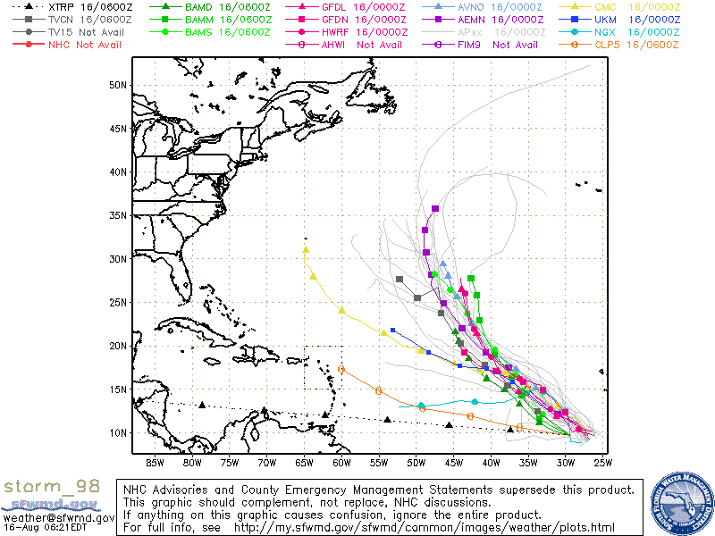
of course the models that put it in our better swell window are some of the least reliable of the bunch. |
|
|
|
|
|
08/16/2016 08:07 AM
|
|
|
so glad that i just picked up my board last night from being repaired
#StokedToSurf ------------------------- hey, i don't know if you read this yet ----------> I <3 16streets.com thank you Sean O'hare Delicious beer comes from here |
|
|
|
|
|
08/16/2016 08:24 AM
|
|
|
ugh!! Thats it ! you just lowered our chances of a good swell! Thanks a lot !! Only way to fix this Rick is if you take you and your "repared" board to CR or some other far away place then the storm will be back on track for FLorida swell. |
|
|
|
|
|
08/16/2016 08:26 AM
|
|
|
Nothing to see here if/when Fiona is named it will spin N/NW and way out of our swell window...someone please go to Bermuda and score "Tucks". Bring on the next one ...Gaston, the shortboard is getting dusty. |
|
|
|
|
|
08/16/2016 09:08 AM
|
|
|
Could make for a worthy Hatteras run!?
------------------------- I troll 2L.com to be a better person in real life |
|
|
|
|
|
08/16/2016 09:36 AM
|
|
|
For you forecast guru's, which one of these like 15 models would you say has had the best track record in the past lets say 5 years? I'm thought it was the UKM deal a few years back but recently it's seemed to be NOT the best\most reliable one. lol ------------------------- SK8 AND DESTROY |
|
|
|
|
|
08/16/2016 10:24 AM
|
|
|
Oh no! Possible storms! Quick man the haarp weapon! |
|
|
|
|
|
08/16/2016 10:48 AM
|
|
|
nothing to see here folks, move along. i am beginning to think we should just start hoping for the first cold front and do other stuff for another month. these over-blown trade swell forecasts are getting old.
|
|
|
|
|
|
08/16/2016 10:51 AM
|
|
|
I'm NO meterologist, but I'd say the GFDL, GFS and Euro (ECWMF? the one with a long accronym Been awhile since there's been enough canes worth paying attention to. I don't follow as closely as I used to, as it usually just ends in Charlie Brown esque disappointment
I will say when one is WAY different than the others, I prob wouldn't bank on that. |
|
|
|
|
|
08/16/2016 11:32 AM
|
|
|
Its gonna be a gnarly fucking October!!! This one, 98L, is just a boib shot to get you armchair forcasters jonsing, spouting, & stroking!!! From 09/10 thru 11/01 is gonna guff & someone on the East Coast is gonna take a thumper on the head, but as of now, this intense Bermuda high will have us flat thru Labor Day!!! Col. SV ------------------------- Tubes, Boobs, & Doobs!!! |
|
|
|
|
|
08/16/2016 12:18 PM
|
|
|
Are you the same big rick from the news junkie? |
|
|
|
|
|
08/16/2016 01:47 PM
|
|
|
North turn already happening
|
|
|
|
|
|
08/16/2016 01:56 PM
|
|
|
yes, and the same one who took a bullet like a champ downtown a few years ago
------------------------- Make the Ocean great again. Ban all Bodyboarders |
|
|
|
|
|
08/16/2016 03:47 PM
|
|
|
yes, and the same one who took a bullet like a champ downtown a few years ago
Hah I've heard him on there a few times and always wondered if it was the same dude. Can we hear THAT story? |
|
|
|
|
|
08/16/2016 07:42 PM
|
|
|
TROPICAL WEATHER OUTLOOK
NWS NATIONAL HURRICANE CENTER MIAMI FL 800 PM EDT TUE AUG 16 2016 For the North Atlantic...Caribbean Sea and the Gulf of Mexico: 1. Showers and thunderstorms associated with a low pressure area located about 650 miles west-southwest of the Cabo Verde Islands have become more concentrated and better organized during the past several hours. If this development trend continues, advisories would be initiated on a tropical depression tonight or Wednesday. This system is expected to move generally northwestward over the open waters of the central Atlantic during the next several days. * Formation chance through 48 hours...high...90 percent * Formation chance through 5 days...high...90 percent |
|
|
|
|
|
08/16/2016 07:45 PM
|
|
|
And, , , , as we all should know, , , , the models "grip" on the track((s) is total BS until the supposed system gets better organized.
------------------------- Dora Hates You |
|
|
|
|
|
08/16/2016 07:51 PM
|
|
|
Were not getting waves from 98L you jonsers!!! ------------------------- Tubes, Boobs, & Doobs!!! |
|
|
|
|

FORUMS
:
Surfing
:
Way out in the Atlantic, Cape Verde possibility
|
Topic Tools |
FuseTalk Basic Edition - © 1999-2024 FuseTalk Inc. All rights reserved.