
 |
2nd Light Forums |
 |
 |  |


|
Topic Title: Let the Hype Begin Topic Summary: Labor day Weekend Created On: 08/13/2014 07:24 AM |
Linear : Threading : Single : Branch |
|
 Topic Tools Topic Tools
|

 08/22/2014 04:25 PM 08/22/2014 04:25 PM


|
|||
|
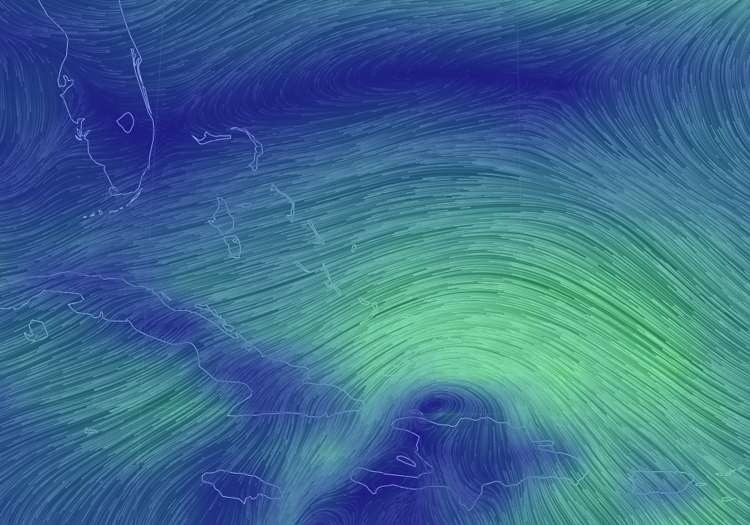
New run of the GFS has it hitting Jupiter Wednesday morning. LOL This is going to be a long back-and-forth weekend! You can't trust any of the models right now because the storm hasn't formed yet. They are just guessing on where to put the start point. Each time it's a little different, thus each model run is different. There is a fine line right now on what option opens up. A little bit left, and the trough doesn't pick it up, a little bit right and the trough pulls it north. There's also a slim possibility the southern part of it breaks off and heads to the gulf to form its own system. This started as two tropical waves.
------------------------- WPTV NewsChannel5/Fox 29 Snapchat: Surfnweatherman
|
|||
|
|
|||
|
08/22/2014 05:58 PM
|
|||
|
Δ Well spoken, and thanks for sharing / posting...
One thing to also consider is while we all know out to 5+ days these models are having high error when we have not perfect inital conditions / inital data to enter the error gets even more magnified, any small little change in ivc can really change a lot...thats right what were dealing with now and I'd expect that later this weekend
While this set up is very reminicent I truly hope none of those south Florida runs come true and as always during casne season I'll be praying that the storm sends nice swell but turns out to sea not causing any damage to property or life ------------------------- get up early and go surf - it'll make that hangover go away and/or make the workday more tolerable :) |
|||
|
|
|||
|
08/23/2014 05:02 AM
|
|||
|
HUNKER DOWN !!!
LOL. |
|||
|
|
|||
|
08/23/2014 06:47 AM
|
|||
|
We may see this come in on Sunday!
Big SE swell on East Bahama buoy http://www.ndbc.noaa.gov/stati...p?station=41046 |
|||
|
|
|||
|
08/23/2014 07:05 AM
|
|||
|
E Bahama
------------------------- So if you are a surfer I wish you the prosperity that allows you more time to pursue the salt water dream, and the true happiness that comes from warm water, clean waves and the companionship of your fellow surfers. If you are an internet troll just spewing bs then f off. |
|||
|
|
|||
|
08/23/2014 07:19 AM
|
|||
|
|
|||
|
08/23/2014 07:50 AM
|
|||
|
VAS conditions? ------------------------- Jesus invented surfing... www.facebook.com/churchonthebeach |
|||
|
|
|||
|
08/23/2014 10:16 AM
|
|||

GFS? You know if it stays just offshore then the winds going to go NW and SW after the center passes to the north. All this shit about NE winds and VAS the whole time would be out the window. I've seen them wind forecast like that before and given the circumstances a forced west wind is always the case. As long as it's close enough to the coast to take over the local wind patterns.... Edited: 08/23/2014 at 10:30 AM by Northjetty101 |
|||
|
|
|||
|
08/23/2014 01:37 PM
|
|||
|
|
|||
|
08/23/2014 02:12 PM
|
|||
|
Crowds will be mental, but I will be there
|
|||
|
|
|||
|
08/23/2014 02:17 PM
|
|||
|
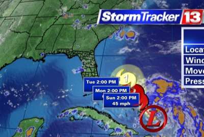
Tropical Depression 4 as of 5:00 pm.
Edited: 08/23/2014 at 02:26 PM by Northjetty101 |
|||
|
|
|||
|
08/23/2014 02:57 PM
|
|||
|
|
|||
|
08/23/2014 03:00 PM
|
|||
|
Could be similar to 2011's Irene? Same time of the year, too...
------------------------- 
|
|||
|
|
|||
|
08/23/2014 03:32 PM
|
|||
|
Ohhhhh yeah category 10 coming for us LOL...Just does remind me of 92 - quiet start then boom...guess some bad memories just won't go away and just never know.
Anyways, if it does take the track nhc is predicting i'm thinking Tuesday DP will be a nice little start to my workweek
------------------------- get up early and go surf - it'll make that hangover go away and/or make the workday more tolerable :) Edited: 08/23/2014 at 03:54 PM by surferclimber |
|||
|
|
|||
|
08/23/2014 03:56 PM
|
|||

Wed - Thursday for a N, NW, SW wind switch? |
|||
|
|
|||
|
08/23/2014 04:01 PM
|
|||
|
My new board and me are frothing!
------------------------- |
|||
|
|
|||
|
08/23/2014 05:25 PM
|
|||
|
When tiptime gets excited so do I.
Be nice to put the fish tail away and ride something that's going to feel new again. |
|||
|
|
|||
|
08/23/2014 08:03 PM
|
|||
|
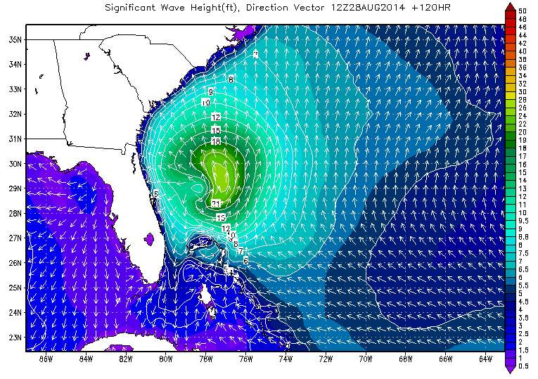
Alright, the NE Bahama buoy jumped from 3' to 6' today. With a swell direction of ESE:
Significant Wave Height Significant Wave Height (WVHT): 6.9 ft Swell Height Swell Height (SwH): 6.6 ft Swell Period Swell Period (SwP): 10.0 sec Swell Direction Swell Direction (SwD): ESE Wind Wave Height Wind Wave Height (WWH): 1.6 ft Wind Wave Period Wind Wave Period (WWP): 4.2 sec Wind Wave Direction Wind Wave Direction (WWD): SE Wave Steepness Wave Steepness (STEEPNESS): AVERAGE Average Wave Period Average Wave Period (APD): 6.9 sec |
|||
|
|
|||
|
08/23/2014 11:14 PM
|
|||
|
Ok me too!!! Yewwwwwwe, luck of the draw, I am off Thursday too! so really what's the rush? Sit and spin for a bit! |
|||
|
|
|||
|
08/24/2014 03:45 AM
|
|||
|
We now have cristobal! Right now my pick for S. FL: Blown out garbage Tuesday Hopefully wind dying off Wednesday morning and it cleaning up and swell peaking Fading swell but clean thursday. Dying Friday. small/flat weekend.
------------------------- WPTV NewsChannel5/Fox 29 Snapchat: Surfnweatherman Edited: 08/24/2014 at 04:44 AM by jwieland |
|||
|
|
|||

FORUMS
:
Surfing
:
Let the Hype Begin
|
Topic Tools |
FuseTalk Basic Edition - © 1999-2024 FuseTalk Inc. All rights reserved.