
 |
2nd Light Forums |
 |
 |  |


|
Topic Title: There is a chance! Topic Summary: Gulf system Created On: 05/14/2018 11:53 AM |
Linear : Threading : Single : Branch |
 |
- Central Floridave | - 05/14/2018 11:53 AM |
|
- Plan B | - 05/14/2018 12:07 PM |
|
- ww | - 05/14/2018 07:08 PM |
|
- ILM | - 05/15/2018 05:56 AM |
|
- Central Floridave | - 05/16/2018 05:13 AM |
|
- ILM | - 05/16/2018 06:18 AM |
|
- Plan B | - 05/16/2018 06:40 AM |
|
- ILM | - 05/16/2018 06:48 AM |
|
- Plan B | - 05/16/2018 08:19 AM |
|
- Zephyr | - 05/17/2018 04:51 PM |
|
- thetracker | - 05/17/2018 07:54 PM |
|
- Cole | - 05/17/2018 08:34 PM |
|
- ILM | - 05/18/2018 05:17 AM |
|
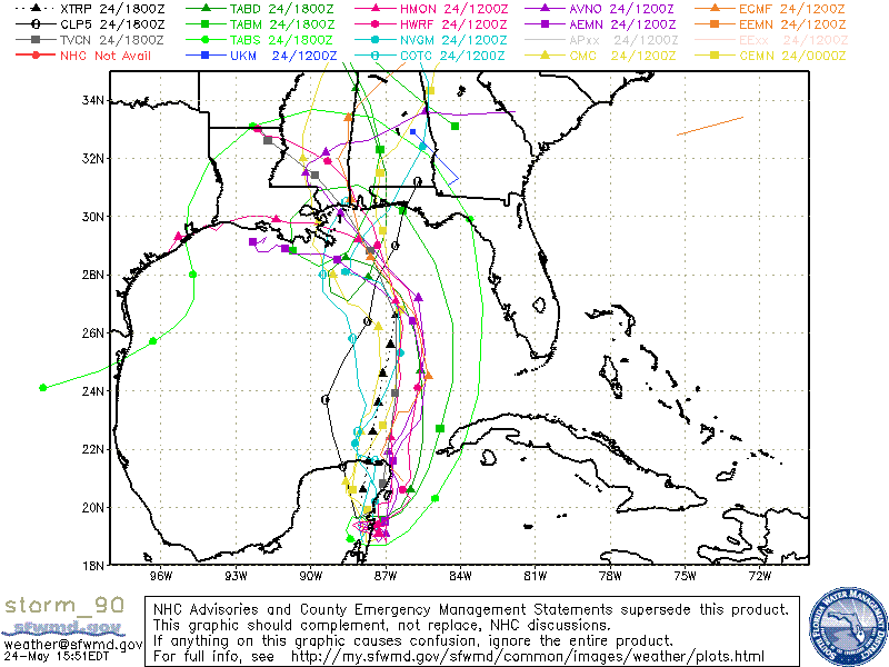
- long_flaco1 | - 05/24/2018 06:56 AM |
|
- LostSherpa | - 05/24/2018 07:22 AM |
|
- LostSherpa | - 05/24/2018 07:22 AM |
|
- LostSherpa | - 05/24/2018 07:23 AM |
|
- Plan B | - 05/24/2018 08:43 AM |
|
- RiddleMe | - 05/24/2018 09:27 AM |
|
- ww | - 05/24/2018 12:01 PM |
|
- dingpatch | - 05/24/2018 01:05 PM |
|
- ww | - 05/25/2018 05:18 AM |
|
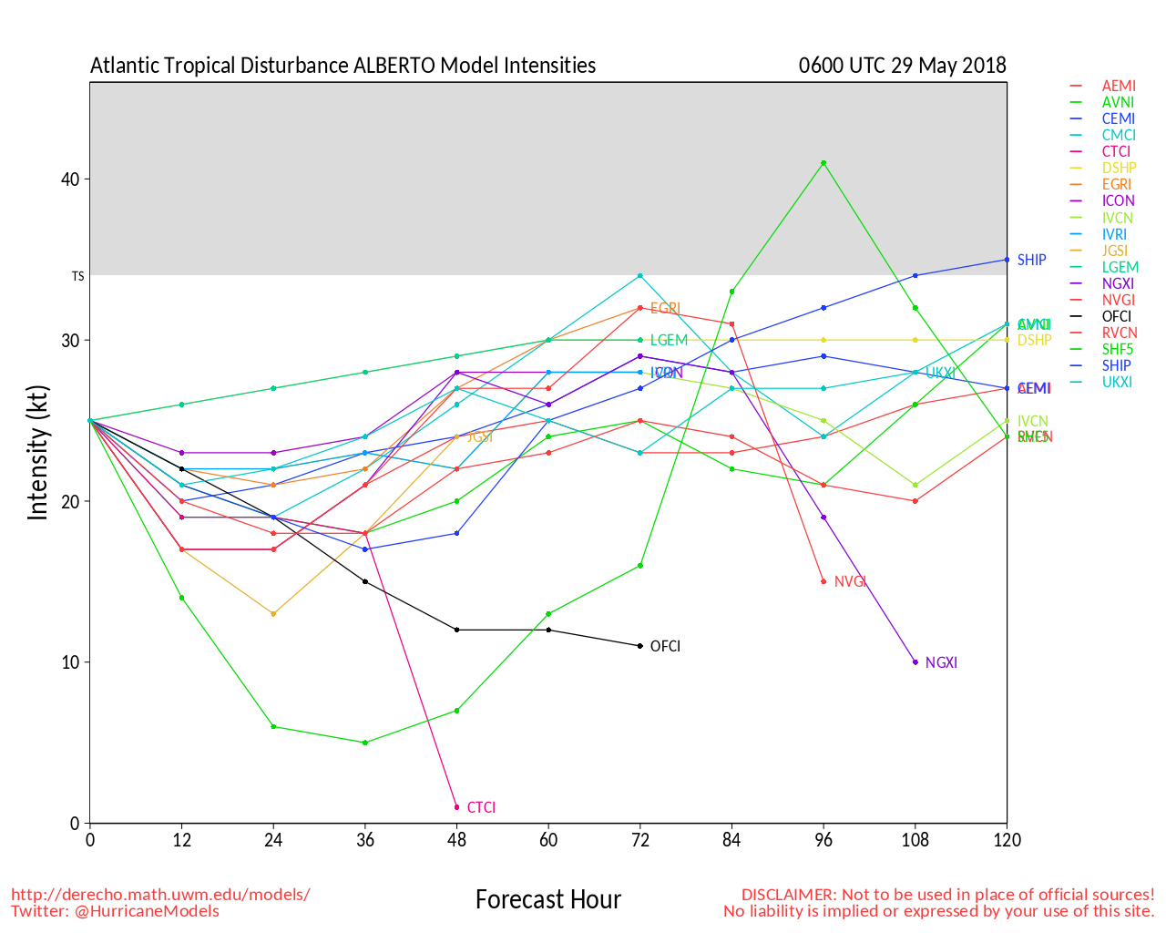
- surfsail | - 05/28/2018 01:58 PM |
|
- SurferMic | - 05/28/2018 07:53 PM |
|
- Cole | - 05/29/2018 04:58 AM |
|
- harrietdubman | - 05/29/2018 07:27 AM |
|
- stokedpanda | - 05/25/2018 05:19 AM |
|
- tom | - 05/25/2018 05:38 AM |
|
- scombrid | - 05/25/2018 06:33 AM |
|
- surfmcc32 | - 05/25/2018 06:15 PM |
|
- scostuart | - 05/26/2018 04:43 AM |
|
- LBLarry | - 05/26/2018 05:15 AM |
|
- Plan B | - 05/26/2018 06:29 AM |
|
- miker | - 05/25/2018 07:41 AM |
|
- Central Floridave | - 05/26/2018 10:12 AM |
|
- surfmcc32 | - 05/26/2018 12:14 PM |
|
- Central Floridave | - 05/26/2018 01:42 PM |
|
- rc | - 05/26/2018 05:15 PM |
|
- elltabrotsen | - 05/26/2018 07:05 PM |
|
- Plan B | - 05/28/2018 10:49 AM |
|
- RiddleMe | - 05/28/2018 11:25 AM |
|
- surfmcc32 | - 05/28/2018 11:37 AM |
|
- Plan B | - 05/28/2018 01:10 PM |
|
- daner | - 05/29/2018 07:20 AM |
|
- surfmcc32 | - 05/29/2018 07:37 AM |
|
- surfmcc32 | - 05/29/2018 07:38 AM |
|
- daner | - 05/29/2018 08:15 AM |
|
- SurferMic | - 05/29/2018 01:56 PM |
|
- harrietdubman | - 05/30/2018 12:27 PM |
 Topic Tools Topic Tools
|

 05/14/2018 11:53 AM 05/14/2018 11:53 AM


|
|||
|
TTAA00 KNHC DDHHMM
Special Tropical Weather Outlook NWS National Hurricane Center Miami FL 935 AM EDT Mon May 14 2018 For the North Atlantic...Caribbean Sea and the Gulf of Mexico: 1. A large area of cloudiness, showers, and thunderstorms extending from the eastern Gulf of Mexico across much of the Florida Peninsula is associated with a broad surface low pressure area interacting with an upper-level low. This system could acquire some subtropical or tropical characteristics while it moves slowly northward across the eastern Gulf of Mexico during the next few days. Regardless of subtropical or tropical cyclone formation, this system will enhance rainfall across portions of Florida and the northeastern Gulf Coast during the next few days. For more information on this system, please see products issued by your local weather office. The next Special Tropical Weather Outlook on this system will be issued by 4 PM EDT today. * Formation chance through 48 hours...low...30 percent. * Formation chance through 5 days...medium...40 percent. Forecaster Pasch |
|||
|
|
|||
|
05/14/2018 12:07 PM
|
|||
|
a chance of dumping rain all week |
|||
|
|
|||
|
05/14/2018 07:08 PM
|
|||
|
Vero got 2.6". The rest of the week can't be worse. |
|||
|
|
|||
|
05/15/2018 05:56 AM
|
|||
|
Also the GFS and the EURO models show a closed Tropical LOW/system off the FLA. coast of the USA around the 24th or so |
|||
|
|
|||
|
05/16/2018 05:13 AM
|
|||
|
Although we can't trust ten day models, now ILM's vision of a storm is on top of Cuba on the 24/25th. 'Tis the season!
|
|||
|
|
|||
|
05/16/2018 06:18 AM
|
|||
|
Always have to keep faith in the hype train |
|||
|
|
|||
|
05/16/2018 06:40 AM
|
|||
|
Really cant trust anything outside 3 days when it comes to these things |
|||
|
|
|||
|
05/16/2018 06:48 AM
|
|||
|
Really cant trust anything outside 3 days when it comes to these things
Nope, even 3 days is a stretch, but you never know.....
|
|||
|
|
|||
|
05/16/2018 08:19 AM
|
|||
|
no doubt, but that's when things get interesting.... I'll be keeping an eye on that. Holiday weekend crowd may discourage my road trip even if things materialize |
|||
|
|
|||
|
05/17/2018 04:51 PM
|
|||
|
I'll be packing a moving truck that weekend which tells me that, if a system forms, it will come on shore and dump torrential rains as I try and move my family into our new home. Sorry guys. |
|||
|
|
|||
|
05/17/2018 07:54 PM
|
|||
|
That's not how it works Zephyr, the waves will likely be firing when you have to load the moving truck. We appreciate the sacrifice bruddah |
|||
|
|
|||
|
05/17/2018 08:34 PM
|
|||
|
I worked from home Monday, Tuesday and Wednesday, then did ten hours in the field today.
Yea! ------------------------- I was right. |
|||
|
|
|||
|
05/18/2018 05:17 AM
|
|||
|
https://www.tropicaltidbits.com/analysis/models/?model=gfs®ion=us&pkg=mslp_pcpn_frzn&runtime=2018051806&fh=204
hopefully keeps shifting east and off the coast to shoot some swell up here.
|
|||
|
|
|||
|
05/24/2018 06:56 AM
|
|||
|
Anybody think there still may be a chance for "goodness" Sunday\Monday in Brevard? Forecasters are all over the place so far.
------------------------- SK8 AND DESTROY |
|||
|
|
|||
|
05/24/2018 07:22 AM
|
|||
|
I am going to surf right infront of my house this weekend in south Florida! stoked... I live 15 miles from the beach....gon rain ------------------------- The Dude Abides. |
|||
|
|
|||
|
05/24/2018 07:22 AM
|
|||
|
I am going to surf right infront of my house this weekend in south Florida! stoked... I live 15 miles from the beach....gon rain ------------------------- The Dude Abides. |
|||
|
|
|||
|
05/24/2018 07:23 AM
|
|||
|
I am going to surf right infront of my house this weekend in south Florida! stoked... I live 15 miles from the beach....gon rain ------------------------- The Dude Abides. |
|||
|
|
|||
|
05/24/2018 08:43 AM
|
|||
|
Next model run is soon, but ATM looking like a bust.... sans maybe a few hrs in the panhandle |
|||
|
|
|||
|
05/24/2018 09:27 AM
|
|||
|
heading to other coast for long weekend guess i am bringing a board |
|||
|
|
|||
|
05/24/2018 12:01 PM
|
|||
|
NHC boosted development chance to 70% at 2 pm, promises an update by 8 pm. More rain. |
|||
|
|
|||
|
05/24/2018 01:05 PM
|
|||
------------------------- Dora Hates You |
|||
|
|
|||
|
05/25/2018 05:18 AM
|
|||
|
Tropical storm expected, next update by 2 pm. NHC 8 am Sat. |
|||
|
|
|||
|
05/28/2018 01:58 PM
|
|||
|
Looks like yesterday would have been reasonable. Amazons looks like ins ground zero. Prob was good before it got too close. Let's see if anyone got pics. Yesterday saw weather reports with waves and offshore Clearwater tec Offshore west of there. San blas etc and points east will be a washing machine / VAS.. ------------------------- There are NO white people at all in the Bible... take all the time you need with that... Please stop feeding the trolls - they will go away if you do... |
|||
|
|
|||
|
05/28/2018 07:53 PM
|
|||
|
Went N. to a state w/ an offshore buoy reading of 9.2 @ 8 sec...well worth it, got tossed and made some air drops.... only 3 out...sandy brown water so much fun Edited: 05/29/2018 at 05:47 AM by SurferMic
|
|||
|
|
|||
|
05/29/2018 04:58 AM
|
|||
|
Went N. to a state w/ an offshore buoy reading of 9.2 @ 8 sec...well worth it, get tossed and made some air drops.... only 3 out...sandy brown water so much fun Nice little adventure. Did you know the spot or just luck out? ------------------------- I was right. |
|||
|
|
|||
|
05/29/2018 07:27 AM
|
|||
|
kakalak ------------------------- sneedeker |
|||
|
|
|||
|
05/25/2018 05:19 AM
|
|||
|
Anybody think there still may be a chance for "goodness" Sunday\Monday in Brevard? Forecasters are all over the place so far. Orange beach AL could be the call! ------------------------- I troll 2L.com to be a better person in real life |
|||
|
|
|||
|
05/25/2018 05:38 AM
|
|||
|
Too late for the mullet toss though. http://www.florabama.com/mullet-toss.html ------------------------- add a signature since I'm here in profile anyway |
|||
|
|
|||
|
05/25/2018 06:33 AM
|
|||
|
Model tracks get sillly as it approaches the northern gulf. Wonder if this will be an unpredictable slow soaking wanderer like Debbie in 2012. ------------------------- ... |
|||
|
|
|||
|
05/25/2018 06:15 PM
|
|||
|
Anyone driving up? Looks like Sunday in pcb or capesandblast could get pretty fun... |
|||
|
|
|||
|
05/26/2018 04:43 AM
|
|||
|
www.mrsurfs.com ------------------------- Waiting for waves is ok......most people spend their lives waiting for nothing. |
|||
|
|
|||
|
05/26/2018 05:15 AM
|
|||
|
www.mrsurfs.com ya got a report site from that area that does not "preach the gospel" to me? ------------------------- "Most people would die sooner than think; in fact, they do." - Bertrand Russell "Morality is doing what is right, regardless of what you are told. Religion is doing what you are told, regardless of what is right. If I do not answer you .... nothing personal, I just have you on ignore. |
|||
|
|
|||
|
05/26/2018 06:29 AM
|
|||
|
possibly, but it'll be a gametime decision..... but the fact that I have a brutal hangover almost gurantees it'll be firing |
|||
|
|
|||
|
05/25/2018 07:41 AM
|
|||
|
Too late for the mullet toss though. [IMG][/IMG] Whoever though it was a good idea to make their website like that needs to be slapped. |
|||
|
|
|||
|
05/26/2018 10:12 AM
|
|||
|
Good luck Gulf Surfers! Catch one or three for all of us.
|
|||
|
|
|||
|
05/26/2018 12:14 PM
|
|||
|
I’m going for it, if anyone else is going and wants to surf around the pcb or cape San blas area shoot me a pm. |
|||
|
|
|||
|
05/26/2018 01:42 PM
|
|||
|
Subtropical Storm Alberto Discussion Number 5
NWS National Hurricane Center Miami FL AL012018 1100 AM EDT Sat May 26 2018 There has been an increase in convection to the east and southeast of the center of Alberto this morning, however, the overall organization of the system has not changed much. Visible satellite imagery and recent reconnaissance aircraft data suggest that the circulation is somewhat elongated and a new low-level center could be forming just northwest of the western tip of Cuba. As suggested by the global models there could be several re-formations of or a discontinuity in the track of the low-level center today. Although there have been no recent observations to support the 35-kt intensity, the intensity is held at that value since the aircraft has not sampled the area well east of the center and due to the overall increase in convection. A shortwave trough dropping southeastward over the northwestern Gulf of Mexico is expected to sharpen the larger negatively tilted trough over the eastern Gulf, which is expected to cause the cyclone to deepen during the next 24 to 36 hours. This trend is consistent with the global model guidance which unanimously strengthen Alberto through Sunday. After that time, Alberto is expected to be co-located with the upper-level low which should result in some decrease in shear and a possible transition to a more tropical cyclone-like structure. The NHC intensity forecast calls for steady strengthening, but only the ECMWF-based SHIPS guidance brings Alberto near hurricane strength before landfall. Steady weakening should occur after the center moves inland. Alberto is moving northward to north-northeastward at about 9 kt. The cyclone should continue on this general heading today, but it is expected to turn north-northwestward and slow down on Sunday and Sunday night as it interacts with the mid- to upper-level trough/low over the Gulf. The track guidance has shifted slightly eastward this cycle and the NHC forecast has been adjusted accordingly. The new NHC track is near a blend of the ECMWF and GFS models, but it is not as far east as the UKMET or the TVCA multi-model consensus. The eastward adjustment in the track forecast has required the issuance of a tropical storm watch for a portion of the west coast of Florida and an eastward nudge of the watch along the coast of the Florida panhandle. KEY MESSAGES: 1. Regardless of its exact track and intensity, Alberto is expected to produce heavy rainfall and flash flooding over western Cuba, southern Florida and the Florida Keys. Rainfall and flooding potential will increase across the central U.S. Gulf Coast region and over much of the southeastern United States beginning Sunday and will continue into next week. 2. Tropical-storm-force winds and hazardous storm surge are possible along portions of the central and eastern U.S. Gulf Coast beginning on Sunday, including areas well east of the track of Alberto's center, and tropical storm and storm surge watches are in effect for portions of these areas. Residents in the watch areas are encouraged not to focus on the details of the forecast track of Alberto and should follow any guidance given by their local government officials. 3. Dangerous surf and rip current conditions are affecting portions of the Yucatan Peninsula and western Cuba and will likely spread along the eastern and central U.S. Gulf Coast later today and tonight. FORECAST POSITIONS AND MAX WINDS INIT 26/1500Z 21.6N 84.9W 35 KT 40 MPH 12H 27/0000Z 23.8N 84.6W 40 KT 45 MPH 24H 27/1200Z 26.0N 85.1W 45 KT 50 MPH 36H 28/0000Z 27.4N 86.0W 50 KT 60 MPH...TROPICAL CYCLONE 48H 28/1200Z 28.7N 86.6W 55 KT 65 MPH...TROPICAL CYCLONE 72H 29/1200Z 31.6N 87.7W 40 KT 45 MPH...INLAND 96H 30/1200Z 35.6N 88.2W 25 KT 30 MPH...INLAND 120H 31/1200Z 39.0N 85.0W 20 KT 25 MPH...INLAND $$ Forecaster Brown |
|||
|
|
|||
|
05/26/2018 05:15 PM
|
|||
|
|
|||
|
05/26/2018 07:05 PM
|
|||
|
Levi was very informative. Thanks ------------------------- "If the highest aim of a captain were to preserve his ship, he would keep it in port forever."-"Now relaxation of the mind from work consists on playful words or deeds. It becomes a wise and virtuous man to have recourse to such things at times." St. Thomas Aquinas ("The Angelic Doctor") |
|||
|
|
|||
|
05/28/2018 10:49 AM
|
|||
|
Storm stayed too close to the coast..... so wasnt very exciting overall (at least not to me) There was a brief period around HT when there were some fun dumpers, but too inconsistent.... (not enough waves / spots per people) Good thing I had a cool travel partner, so it was fun either way, as we're both idiots...... but if you didnt go, you didnt miss a whole lot. We saw a Haufbrau house in PCB ?!?! so we were stoked and went there |
|||
|
|
|||
|
05/28/2018 11:25 AM
|
|||
|
total bust where I was at didnt bother breaking out my board slop |
|||
|
|
|||
|
05/28/2018 11:37 AM
|
|||
|
pretty fun in the morning with chest-maybe shoulder high sets at city pier in pcb, made a couple fun barrells that made the trip worth it to me..but kinda got skunked with it being so far east so the cape was flat, I probably wouldnt have made the trip had I known how small it would get in the afternoon. side note- pcb is a f*cking zoo I cant imagine living with that many oblivious tourists.
|
|||
|
|
|||
|
05/28/2018 01:10 PM
|
|||
|
Pretty fair summary |
|||
|
|
|||
|
05/29/2018 07:20 AM
|
|||
|
Driving for waves always a crap shoot. Especially to the Gulf or South FL. Here now gone in an hour. OR you can hit it epic and score. This storm best waves I saw were right here on the east coast of central FL.
------------------------- Replace turf grass with native plants that don't need irrigation and synthetic fertilizers or chemicals that can go into our waterways and ocean |
|||
|
|
|||
|
05/29/2018 07:37 AM
|
|||
|
oh its fickle for sure, but when it turns on up there its my favorite place to surf in the state. the forecast always looks pretty similar and i've caught it overhead and just reeling lefts down the beach and also driven up and didnt even touch the water it was so small. It looked pretty crappy here i thought? chest-shoulder and windy as hell is the report i heard from a buddy. looks like Pensecola turned on for a little bit yesterday morning. https://www.instagram.com/p/BjV_1enlV9D/?hl=en&taken-by=sterlingspencer |
|||
|
|
|||
|
05/29/2018 07:38 AM
|
|||
|
oh its fickle for sure, but when it turns on up there its my favorite place to surf in the state. the forecast always looks pretty similar and i've caught it overhead and just reeling lefts down the beach and also driven up and didnt even touch the water it was so small. It looked pretty crappy here i thought? chest-shoulder and windy as hell is the report i heard from a buddy. looks like Pensecola turned on for a little bit yesterday morning. https://www.instagram.com/p/BjV_1enlV9D/?hl=en&taken-by=sterlingspencer |
|||
|
|
|||
|
05/29/2018 08:15 AM
|
|||
|
It was worth a shot going over- thought about it too. That is a sweet pic from Pensecola and I'm not trying to get into a my wave is better than yours thing. The wind here was strong but from the S so you had to surf the inlet on Saturday and that was pretty fun with chest high sets-kinda crowded but not too bad-except 1st peak where you couldn't see the water for the surfers-ridiculous. Sunday morning DP the inlet had dropped in size but my buds and I kept looking and lucked out with SSW light wind and chest plus sets at a secret spot in CFL and just the 3 of us out. Glad you got some fun ones too!
------------------------- Replace turf grass with native plants that don't need irrigation and synthetic fertilizers or chemicals that can go into our waterways and ocean |
|||
|
|
|||
|
05/29/2018 01:56 PM
|
|||
|
^^^^Cole...I saw the fetch from deep off our coast directly to a certain island that faces due South somewhere well above Georgia; . Pics never do it justice, but I got humbled on a few late drops. This place breaks hard for its size..my friend broke his leg many ago when he got drilled feet first...snapped his femur like a toothpick. Edited: 05/30/2018 at 05:14 AM by SurferMic |
|||
|
|
|||
|
05/30/2018 12:27 PM
|
|||
|
This place breaks hard for its size..my friend broke his leg many ago when he got drilled feet first...snapped his femur like a toothpick.
rackalack... i smashed my wrist during irma thanks to a nice shelf drop and a trailer fin--wish i wuda used my thruster despite the small crack in the tail. ------------------------- sneedeker |
|||
|
|
|||
|
FORUMS
:
Surfing
:
There is a chance!
|
Topic Tools |
FuseTalk Basic Edition - © 1999-2024 FuseTalk Inc. All rights reserved.