
 |
2nd Light Forums |
 |
 |  |


|
Topic Title: Irma? Topic Summary: Created On: 08/25/2017 01:13 PM |
Linear : Threading : Single : Branch |
 |
- ww | - 08/25/2017 01:13 PM |
|
- Central Floridave | - 08/25/2017 01:47 PM |
|
- daner | - 08/25/2017 03:02 PM |
|
- dingpatch | - 08/25/2017 03:56 PM |
|
- SurferMic | - 08/26/2017 10:11 PM |
|
- ww | - 08/26/2017 11:54 PM |
|
- freesurfs | - 08/27/2017 03:47 AM |
|
- ww | - 08/28/2017 01:09 AM |
|
- Plan B | - 08/28/2017 06:46 AM |
|
- ncsurf | - 08/28/2017 08:27 AM |
|
- Plan B | - 08/28/2017 11:01 AM |
|
- ww | - 08/28/2017 10:37 PM |
|
- Central Floridave | - 08/29/2017 07:38 AM |
|
- Central Floridave | - 08/30/2017 05:25 AM |
|
- Central Floridave | - 08/31/2017 04:45 AM |
|
- tom | - 08/31/2017 05:48 AM |
|
- frothing321 | - 08/31/2017 08:02 AM |
|
- jwieland | - 08/31/2017 08:53 AM |
|
- Central Floridave | - 08/31/2017 09:07 AM |
|
- jwieland | - 08/31/2017 09:22 AM |
|
- Central Floridave | - 08/31/2017 09:30 AM |
|
- ww | - 08/31/2017 10:58 AM |
|
- frothing321 | - 09/01/2017 06:44 AM |
|
- Greensleeves | - 09/01/2017 06:54 AM |
|
- jwieland | - 09/01/2017 07:15 AM |
|
- Central Floridave | - 09/01/2017 07:23 AM |
|
- harrietdubman | - 09/01/2017 08:15 AM |
|
- Skunkape | - 09/01/2017 04:13 PM |
|
- SoHiGH | - 09/01/2017 05:33 PM |
|
- ww | - 09/01/2017 07:53 PM |
|
- paddleout | - 09/01/2017 08:35 PM |
|
- big rick | - 09/02/2017 06:47 AM |
|
- big rick | - 09/02/2017 06:48 AM |
|
- dingpatch | - 09/02/2017 08:21 AM |
|
- ww | - 09/02/2017 02:18 PM |
|
- ww | - 09/02/2017 03:45 PM |
|
- Lunchmeat | - 09/04/2017 06:20 AM |
|
- Central Floridave | - 09/04/2017 06:28 AM |
|
- schmidtstick | - 09/04/2017 06:29 AM |
|
- frothing321 | - 09/04/2017 07:01 AM |
|
- Lunchmeat | - 09/04/2017 07:32 AM |
|
- Noworries | - 09/04/2017 07:38 AM |
|
- ww | - 09/04/2017 07:58 AM |
|
- WG | - 09/04/2017 09:28 AM |
|
- ww | - 09/04/2017 09:54 AM |
|
- SunriseSurfer | - 09/04/2017 10:54 AM |
|
- WG | - 09/04/2017 11:00 AM |
|
- bus | - 09/04/2017 03:36 PM |
|
- Cole | - 09/04/2017 03:44 PM |
|
- scostuart | - 09/04/2017 04:03 PM |
|
- larenyon | - 09/04/2017 04:12 PM |
|
- Burry | - 09/04/2017 01:17 PM |
|
- SunriseSurfer | - 09/04/2017 02:35 PM |
|
- 3rdworldlover | - 09/04/2017 04:24 PM |
|
- paddleout | - 09/04/2017 05:44 PM |
|
- Lunchmeat | - 09/04/2017 06:55 PM |
|
- scostuart | - 09/04/2017 07:02 PM |
|
- MikeNeptune | - 09/04/2017 08:12 PM |
|
- paddleout | - 09/04/2017 08:22 PM |
|
- ridetillibleed | - 09/04/2017 08:32 PM |
|
- paddleout | - 09/04/2017 08:45 PM |
|
- ww | - 09/05/2017 02:24 AM |
|
- paddleout | - 09/05/2017 05:53 AM |
|
- Cole | - 09/05/2017 06:04 AM |
|
- waterlizard25 | - 09/05/2017 06:07 AM |
|
- harrietdubman | - 09/05/2017 06:51 AM |
|
- bus | - 09/05/2017 08:03 AM |
|
- dingpatch | - 09/05/2017 10:48 AM |
|
- stevea | - 09/05/2017 11:02 AM |
|
- dingpatch | - 09/05/2017 11:21 AM |
|
- hustin | - 09/05/2017 11:24 AM |
|
- Central Floridave | - 09/05/2017 11:44 AM |
|
- Noworries | - 09/05/2017 12:16 PM |
|
- StirfryMcflurry | - 09/05/2017 12:26 PM |
|
- ww | - 09/05/2017 12:27 PM |
|
- paddleout | - 09/05/2017 12:24 PM |
|
- TONYlookaround | - 09/05/2017 12:33 PM |
|
- Karma | - 09/05/2017 12:36 PM |
|
- paddleout | - 09/05/2017 12:40 PM |
|
- scostuart | - 09/05/2017 12:48 PM |
|
- scombrid | - 09/05/2017 05:40 PM |
|
- TONYlookaround | - 09/05/2017 06:32 PM |
|
- surfnole | - 09/05/2017 06:52 PM |
|
- larenyon | - 09/05/2017 07:11 PM |
|
- ww | - 09/05/2017 07:43 PM |
|
- BLat | - 09/05/2017 08:00 PM |
|
- StirfryMcflurry | - 09/06/2017 02:56 AM |
|
- TONYlookaround | - 09/06/2017 03:09 AM |
|
- Cole | - 09/06/2017 06:27 AM |
|
- paddleout | - 09/05/2017 12:41 PM |
|
- TONYlookaround | - 09/05/2017 12:46 PM |
|
- Central Floridave | - 09/05/2017 01:57 PM |
|
- onegoodturn | - 09/05/2017 02:59 PM |
|
- surfsail | - 09/05/2017 03:01 PM |
|
- Lunchmeat | - 09/05/2017 03:21 PM |
|
- 3rdworldlover | - 09/05/2017 05:23 PM |
|
- paddleout | - 09/05/2017 03:27 PM |
|
- Lunchmeat | - 09/05/2017 03:44 PM |
|
- surfrc | - 09/05/2017 04:23 PM |
|
- scombrid | - 09/05/2017 05:32 PM |
|
- paddleout | - 09/05/2017 04:54 PM |
|
- BLat | - 09/05/2017 05:04 PM |
|
- Cole | - 09/05/2017 05:05 PM |
|
- paddleout | - 09/05/2017 07:49 PM |
|
- paddleout | - 09/05/2017 08:04 PM |
|
- 3rdworldlover | - 09/05/2017 09:14 PM |
|
- ww | - 09/06/2017 02:48 AM |
|
- surfgal | - 09/06/2017 02:45 AM |
|
- paddleout | - 09/06/2017 03:24 AM |
|
- chopola | - 09/06/2017 03:27 AM |
|
- TONYlookaround | - 09/06/2017 03:32 AM |
|
- Plan B | - 09/06/2017 04:20 AM |
|
- miker | - 09/06/2017 05:01 AM |
|
- DaveFL76 | - 09/06/2017 05:11 AM |
|
- 3rdworldlover | - 09/06/2017 06:09 AM |
|
- WG | - 09/06/2017 06:37 AM |
|
- miker | - 09/06/2017 07:20 AM |
|
- Greensleeves | - 09/06/2017 07:31 AM |
|
- scombrid | - 09/06/2017 07:47 AM |
|
- miker | - 09/06/2017 08:02 AM |
|
- TONYlookaround | - 09/06/2017 08:54 AM |
|
- scombrid | - 09/06/2017 09:10 AM |
|
- ww | - 09/06/2017 09:52 AM |
|
- TONYlookaround | - 09/06/2017 10:52 AM |
|
- TONYlookaround | - 09/06/2017 11:16 AM |
|
- StirfryMcflurry | - 09/06/2017 11:20 AM |
|
- WG | - 09/06/2017 11:30 AM |
|
- equipeola | - 09/06/2017 12:48 PM |
|
- ww | - 09/06/2017 01:17 PM |
|
- equipeola | - 09/06/2017 02:54 PM |
|
- miker | - 09/06/2017 11:49 AM |
|
- TONYlookaround | - 09/06/2017 12:09 PM |
|
- miker | - 09/06/2017 08:06 AM |
|
- miker | - 09/06/2017 09:49 AM |
|
- Central Floridave | - 09/06/2017 10:03 AM |
|
- GsusSurfs | - 09/06/2017 10:06 AM |
|
- mushyman | - 09/06/2017 02:58 PM |
|
- dingpatch | - 09/06/2017 06:32 PM |
|
- seaspray | - 09/07/2017 01:14 AM |
|
- miker | - 09/07/2017 01:30 AM |
|
- seaspray | - 09/07/2017 01:43 AM |
|
- miker | - 09/07/2017 02:56 AM |
|
- dingpatch | - 09/07/2017 04:23 AM |
|
- MikeNeptune | - 09/07/2017 09:24 AM |
|
- harrietdubman | - 09/07/2017 10:26 AM |
|
- 3rdworldlover | - 09/07/2017 05:49 AM |
|
- seaspray | - 09/07/2017 05:56 AM |
|
- Cole | - 09/07/2017 06:30 AM |
|
- paddleout | - 09/07/2017 06:44 AM |
|
- Karma | - 09/07/2017 07:55 AM |
|
- Central Floridave | - 09/07/2017 08:15 AM |
|
- Karma | - 09/07/2017 08:22 AM |
|
- Zeus | - 09/07/2017 09:16 AM |
|
- GsusSurfs | - 09/07/2017 09:21 AM |
|
- Cole | - 09/07/2017 09:31 AM |
|
- paddleout | - 09/07/2017 09:35 AM |
|
- GsusSurfs | - 09/07/2017 09:41 AM |
|
- rose_surfer | - 09/07/2017 09:42 AM |
|
- GsusSurfs | - 09/07/2017 09:48 AM |
|
- Central Floridave | - 09/07/2017 10:46 AM |
|
- weldertom2 | - 09/07/2017 11:40 AM |
|
- zoomino | - 09/07/2017 11:52 AM |
|
- ww | - 09/07/2017 12:31 PM |
|
- Cole | - 09/07/2017 12:36 PM |
|
- Central Floridave | - 09/07/2017 02:23 PM |
|
- bus | - 09/07/2017 02:48 PM |
|
- TONYlookaround | - 09/07/2017 04:39 PM |
|
- paddleout | - 09/07/2017 04:46 PM |
|
- ridetillibleed | - 09/07/2017 04:58 PM |
|
- paddleout | - 09/07/2017 05:02 PM |
|
- larenyon | - 09/07/2017 05:53 PM |
|
- ridetillibleed | - 09/07/2017 06:02 PM |
|
- scombrid | - 09/07/2017 06:14 PM |
|
- Cole | - 09/07/2017 07:12 PM |
|
- TONYlookaround | - 09/07/2017 08:35 PM |
|
- RocketSurf | - 09/08/2017 12:32 AM |
|
- paddleout | - 09/07/2017 06:01 PM |
|
- daner | - 09/08/2017 02:32 AM |
|
- harrietdubman | - 09/08/2017 03:00 AM |
|
- surfersensei | - 09/08/2017 03:40 AM |
|
- surfersensei | - 09/08/2017 03:42 AM |
 Topic Tools Topic Tools
|

 08/25/2017 01:13 PM 08/25/2017 01:13 PM


|
|||
|
National Hurricane Center puts development probability for the blob of rain over us at only 50%, but it looks like it might run up the coast, close to the Outer Banks. If so, looks worthless in terms of wave potential. For those with access, Washington Post's Weather Gang has an assessment. |
|||
|
|
|||
|
08/25/2017 01:47 PM
|
|||
|
Been watching the model updates. Hoping it doesn't hug the coast too much. The virtual buoys predictions for next week have been on a downward tick every model run.
|
|||
|
|
|||
|
08/25/2017 03:02 PM
|
|||
|
Yea it's gone from wave s for days to days until waves. FL fkd again. East coast anyway.
------------------------- Replace turf grass with native plants that don't need irrigation and synthetic fertilizers or chemicals that can go into our waterways and ocean |
|||
|
|
|||
|
08/25/2017 03:56 PM
|
|||
|
Irma Gunch, Modine's sister. I was wondering what the circulation over us was.
------------------------- Dora Hates You |
|||
|
|
|||
|
08/26/2017 10:11 PM
|
|||
|
For those with cash to burn $200.00 will get you to Jersey on Spirit (no board , backpack w/ wetsuit stuffed under seat) ...the rest....well....it is good to know someone who lives at the "Shore"...watching...could be done for min cost..the shoobie season is winding down..
Edited: 08/26/2017 at 10:24 PM by SurferMic |
|||
|
|
|||
|
08/26/2017 11:54 PM
|
|||
|
Interesting rain forecast map. A lot of NC is evidently having a severe drought, so it'll rain like crazy offshore. Cold front with low pressure system moving north from Florida. Fly to Islip?
|
|||
|
|
|||
|
08/27/2017 03:47 AM
|
|||
|
Daner ... right on - unfortunately
------------------------- ... positioning and selection |
|||
|
|
|||
|
08/28/2017 01:09 AM
|
|||
|
|
|||
|
08/28/2017 06:46 AM
|
|||
|
meh, the last one that was a full on Cane gave them only one day of surf..... this thing weaker + moving faster = don't blink or you may miss the "swell" we have some waves here today. waiting for tide to fill in and wind to rotate more |
|||
|
|
|||
|
08/28/2017 08:27 AM
|
|||
|
Fly to Islip? No drought on the Outer Banks...been raining basically every day here this summer. |
|||
|
|
|||
|
08/28/2017 11:01 AM
|
|||
|
got fun as the tide filled in like I hoped
|
|||
|
|
|||
|
08/28/2017 10:37 PM
|
|||
|
Great day for Jax and presumably St. Aug. Now to see about the prospective Julia. |
|||
|
|
|||
|
08/29/2017 07:38 AM
|
|||
|
virtual buoys show something from NE friday and Saturday. Could we get so lucky of having a NE swell for a 3 day weekend...(hope not cursing it)....
Potential Tropical Cyclone Ten Discussion Number 7 NWS National Hurricane Center Miami FL AL102017 500 AM EDT Tue Aug 29 2017 The disturbance has developed a center that has been trackable this evening though it is still not well-defined, since it appears to be considerably elongated northeast-southwest. The disturbance continues to display very cold, but extremely asymmetric deep convection with all of the thunderstorm activity east of the center due to strong vertical shear. Moreover, the convection is showing no identifiable banding features. So the system is not yet a tropical cyclone. Regardless of the label we use to describe this hybrid system, maximum winds are around 35 kt based upon a Dvorak classification from TAFB and observed winds just below that from the NDBC Buoy 41013. The initial motion of the disturbance is northeast at a faster rate of about 10 kt. Continued acceleration is expected during the next couple of days as a mid- to upper-level trough over the Great Lakes moves closer to the system. The NHC forecast track takes the disturbance across the North Carolina coastline today. By tonight, the cyclone is forecast to move offshore and accelerate over the Atlantic in the mid-latitude westerlies. The NHC track forecast lies near the middle of the guidance envelope and is not substantially changed from the previous advisory. Given the poor organization of the disturbance and the strong wind shear environment that it is embedded within, the chances of this disturbance becoming a tropical cyclone have decreased to about a coin flip. Nonetheless, the potential impacts of tropical-storm- force winds across portions of North Carolina are likely today even if the system does not become a tropical cyclone. The system is expected to become extratropical in 24 hours or less when it interacts with the aforementioned mid- to upper-level trough. Significant strengthening as an extratropical cyclone is forecast for a couple of days due to baroclinic forcing. No significant change has been made to the NHC intensity forecast. The track, intensity, and wind radii forecasts from 24 to 120 h are based on guidance provided by NOAA's Ocean Prediction Center. FORECAST POSITIONS AND MAX WINDS INIT 29/0900Z 33.5N 78.5W 35 KT 40 MPH...POTENTIAL TROP CYCLONE 12H 29/1800Z 35.4N 76.0W 40 KT 45 MPH 24H 30/0600Z 38.0N 71.5W 50 KT 60 MPH...POST-TROP/EXTRATROP 36H 30/1800Z 39.5N 66.5W 60 KT 70 MPH...POST-TROP/EXTRATROP 48H 31/0600Z 41.0N 61.0W 70 KT 80 MPH...POST-TROP/EXTRATROP 72H 01/0600Z 44.5N 50.0W 50 KT 60 MPH...POST-TROP/EXTRATROP 96H 02/0600Z 50.0N 33.0W 40 KT 45 MPH...POST-TROP/EXTRATROP 120H 03/0600Z 55.0N 19.0W 30 KT 35 MPH...POST-TROP/EXTRATROP |
|||
|
|
|||
|
08/30/2017 05:25 AM
|
|||
|
It is over open water now. Now we wait. Checking the buoys off the Northeast and the waters are being churned up.
Virtual buoys keep it small NE into the 3 day weekend. But, maybe they are wrong. Come on NE swell for the 3 day weekend! |
|||
|
|
|||
|
08/31/2017 04:45 AM
|
|||
|
Looking at those buoys to the North of us. South Hatty, etc. NE swell in the water!
|
|||
|
|
|||
|
08/31/2017 05:48 AM
|
|||
|
Irma gonna get some. You too!
------------------------- add a signature since I'm here in profile anyway |
|||
|
|
|||
|
08/31/2017 08:02 AM
|
|||
|
Irma is either the next Joaquin or the next Andrew :0 |
|||
|
|
|||
|
08/31/2017 08:53 AM
|
|||
|
Irma now a cat 2.
Some model tracks have recurve but the more reliable euro keeps it on a collision course for us, or south of Florida. Chances are it'll come right for us because I leave for Peru to surf the longest left in the world on Tuesday. Which if this thing even threatens us, work cancells my trip
I'm getting a little disgruntled lol. Last year the day I was supposed to surf steamer lane I got called back because of Matthew. The timing if this thing is impeccable ------------------------- WPTV NewsChannel5/Fox 29 Snapchat: Surfnweatherman |
|||
|
|
|||
|
08/31/2017 09:07 AM
|
|||
|
fyi, you know this already, but never plan any going away ventures in the month of September.
|
|||
|
|
|||
|
08/31/2017 09:22 AM
|
|||
|
I know I know lol....Sometimes I don't have a choice when I'm going with a group or it's for an event like a wedding or bday ... ------------------------- WPTV NewsChannel5/Fox 29 Snapchat: Surfnweatherman Edited: 08/31/2017 at 09:41 AM by jwieland |
|||
|
|
|||
|
08/31/2017 09:30 AM
|
|||
|
True. good luck with the travel and lets hope this thing recurves!
|
|||
|
|
|||
|
08/31/2017 10:58 AM
|
|||
|
Last year, I had just enough time for Matthew cleanup, and made it to Japan. I'm cancelling my Sept. Oregon trip. |
|||
|
|
|||
|
09/01/2017 06:44 AM
|
|||
|
this bitches name is irma u better not squirma or she'll blow your house down and make u wanna scerma she a tight little storm winds are stronger than the norm board your shit up and grab your f@#$ board its gonna pump pump pump big tubes tubes tubes drop in hit the lip pull in now its lit the town has been destroyed thanks irma it was a joy -a song by yours truly Frothing321 |
|||
|
|
|||
|
09/01/2017 06:54 AM
|
|||
|
A masterpiece Sir Frothington the III II I. Working on the shutters this weekend. |
|||
|
|
|||
|
09/01/2017 07:15 AM
|
|||
|
hesitantly hopefull this morning. Euro now also keeps irma offshore too. All but the canadian now keeps it offshore. Of course this could flip easily so that's why I'm 'hesitantly' hopeful. You don't need me to tell you this offshore track would light up most of FLorida with EPic swell!
Canadian:
------------------------- WPTV NewsChannel5/Fox 29 Snapchat: Surfnweatherman |
|||
|
|
|||
|
09/01/2017 07:23 AM
|
|||
|
Boo on the canadian. What do they know about tropical Wx. Go back and predict snow storms. LOL.
|
|||
|
|
|||
|
09/01/2017 08:15 AM
|
|||
|
https://soundcloud.com/bassnectar/here-we-go-preview-1
------------------------- sneedeker |
|||
|
|
|||
|
09/01/2017 04:13 PM
|
|||
|
a shitomaker or a widowmaker |
|||
|
|
|||
|
09/01/2017 05:33 PM
|
|||
|
BlowWwwwww MEeeeeeee... Puff puff, pass
------------------------- 
|
|||
|
|
|||
|
09/01/2017 07:53 PM
|
|||
|
Weather Underground this afternoon noted that most hurricanes as far north as Irma end up recurving north, not hitting any mainland areas. But so far it doesn't look promising.
Edited: 09/01/2017 at 08:00 PM by ww
|
|||
|
|
|||
|
09/01/2017 08:35 PM
|
|||
|
I certainly hope it doesnt make landfall.. but its looking like theres a good chance somebody's going to take a hit :/ |
|||
|
|
|||
|
09/02/2017 06:47 AM
|
|||
|
Irma feels too close for comfort
I'll take pictures of all the surf down here and post if I can I looked north of the resort I'm in and sea beach is breaking way the hell out and throwing over crazy ------------------------- hey, i don't know if you read this yet ----------> I <3 16streets.com thank you Sean O'hare Delicious beer comes from here |
|||
|
|
|||
|
09/02/2017 06:48 AM
|
|||
|
Also going to check out other parts of Rincon while here
------------------------- hey, i don't know if you read this yet ----------> I <3 16streets.com thank you Sean O'hare Delicious beer comes from here |
|||
|
|
|||
|
09/02/2017 08:21 AM
|
|||
|
The 11:00 spaghetti run has the models getting closer in "agreement" and it aint lookin too good for NC and on up the coast.
------------------------- Dora Hates You |
|||
|
|
|||
|
09/02/2017 02:18 PM
|
|||
|
The degree of agreement is pretty striking. Weather Underground from a bit earlier shows bad scenarios for Florida. |
|||
|
|
|||
|
09/02/2017 03:45 PM
|
|||
|
Wieland & Co. will have Irma updates starting at 7 pm at TV5. Also, Wieland at Facebook.
|
|||
|
|
|||
|
09/04/2017 06:20 AM
|
|||

------------------------- If it’s legal will do it, if it’s not legal, we’ll figure out how to change the law-Joe Biden |
|||
|
|
|||
|
09/04/2017 06:28 AM
|
|||
|
eek....ground zero...fug...
Just got off roof and cut back some oak limbs and discover some shingles from Hurr Matthew need fixin. Fun Fun. Sux that the wave forecast has gone to hell with the latest. Off to prepare some more. |
|||
|
|
|||
|
09/04/2017 06:29 AM
|
|||
|
Welp, another year of this sheot. I cannot believe in 2004 I had no care in the world. Owning a house changes everything. God speed fellas.
------------------------- There is nothing better than pointing out the shortcomings of others, is there? |
|||
|
|
|||
|
09/04/2017 07:01 AM
|
|||
|
this storm is gonna be alot like matthew, but instead of skimming the coast and not making landfall, its gonna ram it right up floridas ass. |
|||
|
|
|||
|
09/04/2017 07:32 AM
|
|||
|
One potential bright note (for us hopefully), being 7 days out that track is bound to change some
------------------------- If it’s legal will do it, if it’s not legal, we’ll figure out how to change the law-Joe Biden |
|||
|
|
|||
|
09/04/2017 07:38 AM
|
|||
|
|
|||
|
09/04/2017 07:58 AM
|
|||
|
The GFS and European models are suggesting Cuba will be hard hit. It might not be too early to call members of Congress and maybe the White House about encouraging assistance. It might help, too, to postpone re-imposition of travel restrictions. |
|||
|
|
|||
|
09/04/2017 09:28 AM
|
|||

"0z GFS Run: Updated as it comes in: Starts off similar to the last run,Irma's obviously over warmer water now and we may wake up to a stronger hurricane. Are you saying this is a genuine scenario? By 36 hours, it's slightly south of the prior GFS Run, maybe 15 or 20 nm, but generally stays the same course until at least 42 hours out. By Wednesday morning it's getting dangerously close to Barbuda, eyewall goes over Barbuda, then St. Maarten and Anguilla. By the evening it's over the British Virgin Islands (US gets some, but not as much as the northern British VI) It stays north of Puerto Rico (to avoid the inner core), but still gets tropical storm force and maybe hurricane force along the northern side of PR. Closer to HIspaniola this run, hits cat 5 late Thursday night as it nears the Turks and Caicos, and over them Friday morning. Slips west of the Turks and Caicos Friday night, between Cuba and the Bahamas. Saturday morning just offshore Cuba, then rides the northern coastline of Cuba. Sunday morning drifts north from Cuba into the Florida straits. Category 5 landfall upper Keys, headed north AM of Sep 11th, maintains strength through Lake Okeechobee with dirty side of storm going through the populated areas of south Florida. Over Orlando (Still cat 4) by afternoon Back offshore by St. Augustine by the end of the night, still a major another landfall in central Georgia. Automatic winner for most insane GFS vs Florida run of all time. Posting it here for the record, 10th straight US landfall prediction for Irma." http://flhurricane.com/cyclone...8005&an=0&page=0#98005 ------------------------- "The truth is incontrovertible. malice may attack it, ignorance may deride it, but in the end, there it is." -Sir Winston Churchill |
|||
|
|
|||
|
09/04/2017 09:54 AM
|
|||
|
The 1935, 1960 and 1992 hurricanes did a lot to remodel Florida Bay. There used to be really tall, old mangrove forests. |
|||
|
|
|||
|
09/04/2017 10:54 AM
|
|||
|
yuk!! WG ...
...so what state do you evacuate to??? -------------------------  Puerto Rico 11 - 24 - 2013 Puerto Rico 11 - 24 - 2013
|
|||
|
|
|||
|
09/04/2017 11:00 AM
|
|||
|
I'm gonna go visit TeeBird if that scenario happens.
------------------------- "The truth is incontrovertible. malice may attack it, ignorance may deride it, but in the end, there it is." -Sir Winston Churchill |
|||
|
|
|||
|
09/04/2017 03:36 PM
|
|||
|
you gotta pass by my house to get there... |
|||
|
|
|||
|
09/04/2017 03:44 PM
|
|||
|
The new forecast has moved it back over the East Coast of Florida.
Yippee! Two nasty storms within a year! Climate Change, it's not just for politics anymore. ------------------------- I was right. |
|||
|
|
|||
|
09/04/2017 04:03 PM
|
|||
|
Already made condo reservations in Tampa and PCB beach....depending on what track she decides to take. ------------------------- Waiting for waves is ok......most people spend their lives waiting for nothing. |
|||
|
|
|||
|
09/04/2017 04:12 PM
|
|||
|
Interested to see how it interacts with mountains of Haiti/DR and Cuba. Usually hurricanes take a major hit (weakening) from them. |
|||
|
|
|||
|
09/04/2017 01:17 PM
|
|||
|
" ROAD TRIP!!!"
to seaTee Bird!!! Somebody better bring some fried chicken to eat on the way! ------------------------- BurrysBreak Inflation caused The BIG BANG...look it up! |
|||
|
|
|||
|
09/04/2017 02:35 PM
|
|||
|
Scott declares state of emergency, all 67 counties.
LINK .... "ensuring that local governments have ample time, resources and flexibility to get prepared for the dangerous storm." ------------------------- Puerto Rico 11 - 24 - 2013
|
|||
|
|
|||
|
09/04/2017 04:24 PM
|
|||
|
881 mb!
That would break the record for the most intense hurricane strike on the US. 1935 Labor Day Hurricane, 892 mb |
|||
|
|
|||
|
09/04/2017 05:44 PM
|
|||
|
I made a couple reservations- one in orlando as per usual in case we just need to get away a bit. another way up in buckhead, GA in case things get really crazy ill decide which one to keep as we get closer in.. |
|||
|
|
|||
|
09/04/2017 06:55 PM
|
|||
|
On the bright side... offshore winds with another hurricane a few hundred miles off shore almost stationary for a day or 3

------------------------- If it’s legal will do it, if it’s not legal, we’ll figure out how to change the law-Joe Biden |
|||
|
|
|||
|
09/04/2017 07:02 PM
|
|||
|
Doubtful with debris in water and A1A prolly washed out. ------------------------- Waiting for waves is ok......most people spend their lives waiting for nothing. |
|||
|
|
|||
|
09/04/2017 08:12 PM
|
|||
|
Was really hoping it would curve and stay off to coast and then head northeast. Landfall would be a drag. I'm hoping to hit South Carolina, but if there's a chance of it hitting Florida hard that's going to create a lot of people on the road. It'll be a mess. ------------------------- See y’all next summer. |
|||
|
|
|||
|
09/04/2017 08:22 PM
|
|||
|
Latest updates have it nudging slightly to the west. The models are now running more to the center of the state and the west coast than the east coast.
Ironically, right now they are drawing a perfect line through the two hotels I made reservations for LOL. So now I actually booked a 3rd option in Pensacola in case it decides to just rip straight on through. Overkill, probably, but I like to keep our options open.. as I'm seeing Cat 4 all the way til landfall |
|||
|
|
|||
|
09/04/2017 08:32 PM
|
|||
|
Well if trump conservatives are concerned about the Huston bills wait until they see the tab from this potential storm. In Ohio working for the summer so stay safe my Florida brothers |
|||
|
|
|||
|
09/04/2017 08:45 PM
|
|||
|
I hear that- its going to cost big $$$ no matter where it hits |
|||
|
|
|||
|
09/05/2017 02:24 AM
|
|||
|
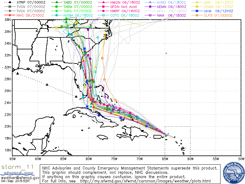
Checked Tropical Tidbits at 5am. GFS and European have very similar paths. This image of GFS is between Big purple at landfall near Naples with windfield extending well out into the Atlantic, and a considerable shrivel that leaves NSB and Daytona with wind at the beach but largely spares Orlando.
NHC: The guidance envelope and many of the ensemble members of the GFS and the ECMWF models have shifted slightly westward since the previous run. The NHC forecast also shifted slightly westward, and it is on top of the multi-model consensus. The confidence in the forecast beyond 3 days is lower, since the guidance spreads out more.
|
|||
|
|
|||
|
09/05/2017 05:53 AM
|
|||
|
New GFS now has it making landfall around homestead/miami, grinding up the coast and popping back out to sea basically at Brevard, then smacking back into S Carolina.
also looks like she is a CAT 5 now :/ with any luck, that projection continues to trend eastward, and she curves off to sea at the last second.. Edited: 09/05/2017 at 06:00 AM by paddleout |
|||
|
|
|||
|
09/05/2017 06:04 AM
|
|||
|
As of the latest report:
COCOA BEACH FL 34 X X( X) X( X) X( X) X( X) 3( 3) 17(20) COCOA BEACH FL 50 X X( X) X( X) X( X) X( X) X( X) 6( 6) COCOA BEACH FL 64 X X( X) X( X) X( X) X( X) X( X) 3( 3) That's a 17% chance of 34 knot winds, 6% 50 knot and 3% for hurricane force at 120 hours out. But depending on speed, none of this means anything. ------------------------- I was right. Edited: 09/05/2017 at 06:21 AM by Cole |
|||
|
|
|||
|
09/05/2017 06:07 AM
|
|||
|
I pray and hope she does but I dont think the curve will be happening this go around. Irma is screaming landfall and extensive damage. Who knows... |
|||
|
|
|||
|
09/05/2017 06:51 AM
|
|||
|
------------------------- sneedeker |
|||
|
|
|||
|
09/05/2017 08:03 AM
|
|||
|
180! |
|||
|
|
|||
|
09/05/2017 10:48 AM
|
|||
|
185 ! !
------------------------- Dora Hates You |
|||
|
|
|||
|
09/05/2017 11:02 AM
|
|||
|
Where to run?... F>>>>>>>>>>?? GAMBLE? LEAVE EARLY IF YOU CAN, WHEN IS EARLY< OR to LATE?? we're out of water at some stores |
|||
|
|
|||
|
09/05/2017 11:21 AM
|
|||
|
No worries. FEMA will take care of everything! Right?
------------------------- Dora Hates You |
|||
|
|
|||
|
09/05/2017 11:24 AM
|
|||
|
5 gallon buckets filled with tap water are better than nothing. $3/ea at the hardware store, but even those stocks are being already listed as "limited". Amazon's already selling out of 5 and 7 gallon containers. |
|||
|
|
|||
|
09/05/2017 11:44 AM
|
|||
|
nhc mentioned this graphic in its discussion. Irma is now strongest ever Hurricane in Atlantic in history:
http://cimss.ssec.wisc.edu/goe...905_1146_1244anim.gif |
|||
|
|
|||
|
09/05/2017 12:16 PM
|
|||
|
Right now it looks like it's going to go up the east coast like Matthew and skirt my house. I can only hope that it weakens or heads east.
|
|||
|
|
|||
|
09/05/2017 12:26 PM
|
|||
|
STRONG user name / post dis-correlation!!! |
|||
|
|
|||
|
09/05/2017 12:27 PM
|
|||
|
Here's Dave's image. Model-wise the GFS sets up a very bad scenario for the Atlantic coast, what Matthew could have been. HWRF has finally gotten to the Keys and, surprise!, it has Irma passing south of Key West and presmumably going on into the Gulf. The NHC's 5 pm should be interesting.
|
|||
|
|
|||
|
09/05/2017 12:24 PM
|
|||
|
If its any consolation, the 6am (12zulu) GFS run has shifted a bit more eastward- and now rather than entering at miami and then popping out at brevard
it is running up the coast- but very close, with the leftside eyewall winds still over the east coast of florida. look bad the way it is, but here is hoping this eastward shift continues and keeps her out at sea http://www.tropicaltidbits.com...512&fh=6&xpos=0&ypos=0 |
|||
|
|
|||
|
09/05/2017 12:33 PM
|
|||
|
really strange how small this storm size is versus the hype of the wind speed. In barbados they got 7-10' swell and they were directly about 200 away from the center of the eye. only a 20mi eye. it's more like a super tornado than a hurricane. Other models have it going past key west into the gulf and nothing more drawn yet...
for comparison in size -- barbados is on the bottom of the screen. It is 20x30 miles - and about the size of the eye. it's not a big island -- you can stand at the top of Gun Hill and see both oceans. This storm is hype. The big one that missed us -- no. it's small. and it's going to lose steam over land and hills of PR and CU.
------------------------- it's never too late to have a happy childhood... Edited: 09/05/2017 at 12:40 PM by TONYlookaround |
|||
|
|
|||
|
09/05/2017 12:36 PM
|
|||
|
European is trending west
------------------------- If you're not part of the solution, you're part of the precipitate. |
|||
|
|
|||
|
09/05/2017 12:40 PM
|
|||
|
We really need to figure out how to dump something from the air into the eyewalls of these hurricanes to disrupt it and break them up. I mean, nobody can figure that out to the tune of all the billions in damage they cause? |
|||
|
|
|||
|
09/05/2017 12:48 PM
|
|||
|
+1 ------------------------- Waiting for waves is ok......most people spend their lives waiting for nothing. |
|||
|
|
|||
|
09/05/2017 05:40 PM
|
|||
|
Company called Dyn-o-Mat was supposedly trying a technique of dumping super-absorbant polymer (baby diaper filler basically) to cause premature condensation in the upper levels to disrupt the updrafts. I believe it to have been an investor scam. Never had any hope of scaling up to the quantity of material (10s of thousands of tons of material per hour dumped into the eyewall) that would be needed to have a measurable impact. The amount of latent heat energy in a hurricane is mind blowing and you wouldn't be able to lift enough material into one with airplanes to make a dent. I would be like trying to stop a Mississippi flood with soup ladels. Dyn-o-Mat claimed to have made a pop-up shower disappear from radar. But anybody that has observed storms that form along the seabreeze front knows that they often spontaineously go "poof" when there is something like dry or warm upper level air inhibiting convection. These diurnal cumulus often have a very short natural lifespan and there was no control for the experiment. I really think it was an investor scam like the Atlant and Aquiess rain-making scams or the fontus self filling water bottle scam. ------------------------- ... Edited: 09/05/2017 at 05:55 PM by scombrid |
|||
|
|
|||
|
09/05/2017 06:32 PM
|
|||
|
Scombrid -- ever see the fleet of C130 sized commercial planes taking off for the storm ? ------------------------- it's never too late to have a happy childhood... |
|||
|
|
|||
|
09/05/2017 06:52 PM
|
|||
|
Quit reading ALGORE, who makes 100s of millions for his companies, and believing the climate alarmists. Shit happens. After 2004 when four major hurricanes hit FLA, the alarmists were claiming a new SUPERCYCLE of hurricanes, and what happened???? Nothing for 10+ years. Not a single major hurricane to hit the USA for 10+ years. But ignore the data.
Chicken little and the sky is falling. Pretty soon you quit believing it.
|
|||
|
|
|||
|
09/05/2017 07:11 PM
|
|||
|
I don't understand why the NHC cone model shows it almost entering the Gulf, yet the GFS and many other models are starting to suggest it could stay off the east coast of FL and hit SC? I thought the cone models were mainly based off the GFS? |
|||
|
|
|||
|
09/05/2017 07:43 PM
|
|||
|
The models have to deal with some complexity with the turn northward. NHC's 5 pm forecast discussion: A large mid-latitude trough over the eastern United States is forecast to _____________________________ The current GFS track has gone far enough offshore to spare us, as Matthew did, but it hits land at Myrtle Beach, S.C. Splat! HWRF hits the Keys about Marathon, goes inland over Everglades National Park, and produces hurricane winds from Port Charlotte to Stuart. Key Largo gets a beating.
|
|||
|
|
|||
|
09/05/2017 08:00 PM
|
|||
|
I'm wondering the same |
|||
|
|
|||
|
09/06/2017 02:56 AM
|
|||
|
Puerto Rico.... |
|||
|
|
|||
|
09/06/2017 03:09 AM
|
|||
|
If I read the colors right -- that is 60kt beachside, maximum. looks like Matthew. 16mph forward speed with a 20mi eye -- I would think limits storm surge to the bottom lower end of the range. There is a full moon right now, which is bad if it's overhead, a higher high tide. In a week it wont be full anymore. Bad for PR. Compare this to Jeanne with a >100mi eye and 3-4mph forward speed... how different could 2 hurricanes be ? I stay with my position that this will be a non-event for us compared to Fake Weather on TV. All I needed to see was the live clips from Home Depot suggesting people to run down and buy buy buy. Miami would panic the most because they have missed everything since Andrew. Also - Barbados was 120 mi from the eye yesterday when it was supposedly cat5. They had 7' swell. that doesnt add up to me - it more like a super tonado than a hurricane. Looked like really fun right barrels on surfline. winds were like 20mph.
------------------------- it's never too late to have a happy childhood... Edited: 09/06/2017 at 03:29 AM by TONYlookaround |
|||
|
|
|||
|
09/06/2017 06:27 AM
|
|||
|
Quit reading ALGORE, who makes 100s of millions for his companies, and believing the climate alarmists. Shit happens. After 2004 when four major hurricanes hit FLA, the alarmists were claiming a new SUPERCYCLE of hurricanes, and what happened???? Nothing for 10+ years. Not a single major hurricane to hit the USA for 10+ years. But ignore the data. Chicken little and the sky is falling. Pretty soon you quit believing it. Right now, Chicken Little is a cat 5 storm meandering it's way to our coast. lol Al Gore ain't got nuthin to do with it. ------------------------- I was right. |
|||
|
|
|||
|
09/05/2017 12:41 PM
|
|||
|
Karma- where do you go to see the European? |
|||
|
|
|||
|
09/05/2017 12:46 PM
|
|||
|
We already have it. http://www.informationliberation.com/?id=12828 thats why the discussion has gone silent -- the murder we are doing to our planet and super heating our oceans... for state farm and allstate profits - think of the billions they have stuffed into their pockets over the last 12 years from the fleet of planes... http://www.anomalies-unlimited.com/Chemtrails/Dyn-O-Gel.html dyn-o-mat was here in Melbourne for a while...
------------------------- it's never too late to have a happy childhood... Edited: 09/05/2017 at 12:54 PM by TONYlookaround |
|||
|
|
|||
|
09/05/2017 01:57 PM
|
|||
|
from 5pm Tuesday:
Fixes from the latest satellite and radar imagery suggest that Irma is moving a little north of due west or 280/13 kt. A strong ridge extending southwestward from the central Atlantic is expected to steer Irma west-northwestward during the couple of days. A large mid-latitude trough over the eastern United States is forecast to lift northeastward, allowing the ridge to build westward and keep Irma on a westward to west-northwestward heading through Friday. Over the weekend, a shortwave trough diving southward over the east-central U.S. is expected to weaken the western portion of the ridge, causing Irma to turn poleward. The dynamical model guidance is in good agreement through 72 hours, but there is increasing spread thereafter. The HWRF, UKMET, and ECMWF show a more southerly track and a sharper turn around day 5, while the GFS is farther north and east late in the period. The NHC track is near a consensus of these models and close to the HFIP corrected consensus. Users are reminded to not focus on the exact forecast track, especially at the longer ranges, since the average NHC track errors are about 175 and 225 statute miles at days 4 and 5, respectively. INIT 05/2100Z 17.1N 59.8W 160 KT 185 MPH 12H 06/0600Z 17.6N 61.8W 155 KT 180 MPH 24H 06/1800Z 18.5N 64.6W 150 KT 175 MPH 36H 07/0600Z 19.5N 67.3W 145 KT 165 MPH 48H 07/1800Z 20.4N 70.1W 140 KT 160 MPH 72H 08/1800Z 21.6N 75.3W 135 KT 155 MPH 96H 09/1800Z 22.7N 79.3W 125 KT 145 MPH 120H 10/1800Z 24.4N 81.5W 120 KT 140 MPH |
|||
|
|
|||
|
09/05/2017 02:59 PM
|
|||
|
we have guys with electric car and space companies with billions that haven't found a way to drop ice into these things....sad. to be a guy who grew up with jestsons on in the backround, what an effing disappointment. 2017 for cryin out loud. segways? plz.....and before we go running off into space for more''exploration' let's fix the mess we've created here first before we go a frappin' on the rest of the universe. |
|||
|
|
|||
|
09/05/2017 03:01 PM
|
|||
|
Latest UK met looks like a Francis/Jeannie/Matthew type affair as far as we in Brevard are concerned.. Potentially real bad and very close.. Way too close for nice clean 16+ sec offshore waves in debris free waters.. 200 miles to the east would have been the call.. I know it's quite a ways off, but as a minimum it looks like cleaning up mucho palm fronds.. I def do not want to deal with fence replacement, roof issues etc - assuming house is 'OK'. Something else to the east way out there, and also a potential in the SW gulf... Busy busy busy!!! Saw a 'Cat 6' headline out there.. WTF? But def not related to 'climate change' - right?.. Forgot how to cut/paste pics or links ... https://www.wunderground.com/hurricane/atlantic/2017/tropical-storm-irma ------------------------- There are NO white people at all in the Bible... take all the time you need with that... Please stop feeding the trolls - they will go away if you do... |
|||
|
|
|||
|
09/05/2017 03:21 PM
|
|||
|
The news keeps saying Irma is the strongest ever in the Atlantic. There have been storms with higher winds and a decent amount lower pressure, in the Atlantic. Just asking. Wilma was 882 at one point.
------------------------- If it’s legal will do it, if it’s not legal, we’ll figure out how to change the law-Joe Biden |
|||
|
|
|||
|
09/05/2017 05:23 PM
|
|||
|
The news keeps saying Irma is the strongest ever in the Atlantic. There have been storms with higher winds and a decent amount lower pressure, in the Atlantic. Just asking. Wilma was 882 at one point. Strongest storm in the Atlantic Ocean, excluding GOMEX and Caribbean. Wilma was in the Caribbean when she hit 882. The open Atlantic is typically a more hostile environment for hurricanes. |
|||
|
|
|||
|
09/05/2017 03:27 PM
|
|||
|
VERY GOOD READ HERE:
http://www.wunderground.com/ca...ntic-hurricane-record "NHC's official 5-day forecast as of 11 am EDT brings Irma to the Florida Keys by Sunday morning. At this point, it appears the most likely course for Irma after its right-hand turn is to move northward near Florida's west coast or up the western side of the peninsula from around Sunday into Monday. This is the scenario favored by the operational 00Z Tuesday run of the European model, as well as two of the highest-probability ensemble members from that run. The other three highest-probability Euro tracks keep Irma offshore, either to the west or east of the Florida peninsula; one of those three tracks results in a landfall in the Florida Panhandle, and the other two would be a devastating blow to The Bahamas. The operational 00Z, and the ensemble members from the 00Z Tuesday GFS model run, are more tightly clustered around a track near or just off Florida's west coast, but again with some variation. The 06Z run of the GFS takes Irma near Miami and along Florida's east coast." LOTS MORE AT LINK ABOVE |
|||
|
|
|||
|
09/05/2017 03:44 PM
|
|||
|
Best site yet for info, for me anyways. I'm sure a lot of you know it already.
http://spaghettimodels.com/ ------------------------- If it’s legal will do it, if it’s not legal, we’ll figure out how to change the law-Joe Biden |
|||
|
|
|||
|
09/05/2017 04:23 PM
|
|||
|
Nobody has mentioned the 18z GFS model run. I felt better when I saw it.
|
|||
|
|
|||
|
09/05/2017 05:32 PM
|
|||
|
That looks better for us. Not NC. I really do hope that the GFS is overdone on intensity after the turn to the north. Of course all the other models are to our west and a lot slower in forward speed than GFS. Blend them all and the next center dot for 2PM Monday will be right around Lake Okeechobee and Brevard will be in the fat end of the uncertainty cone. I'm afraid the front from the west is coming in too early since the front arrives on Thusday while the cyclone is still far away. Front washes out and becomes quasi-stationary. Cyclone lifts north into the weakness and gets hung up around the Carolina mountains or maybe SW Virginia where the rain could be catastrophic. Question then is the 200 mile wide swath of uncertainty for the path north. Which side of the peninsula or straight up the gut?
------------------------- ... |
|||
|
|
|||
|
09/05/2017 04:54 PM
|
|||
|
I just saw it- looks better and on another bright note, nat hurricane center just updated, and brevard looks to be out of the big cone.. |
|||
|
|
|||
|
09/05/2017 05:04 PM
|
|||
|
should we....should we wax the guns...? |
|||
|
|
|||
|
09/05/2017 05:05 PM
|
|||
|
I checked the 10 day forecast for Dauphin Island, Alabama and New Orleans and a front will pass over them on Thursday, then they go on a multi day run of sunny weather and lower humidity, so high pressure is building in. Let's just hope it extends far enough south to turn the Bitch away from our coast.
------------------------- I was right. |
|||
|
|
|||
|
09/05/2017 07:49 PM
|
|||
|
New NHC chart is out and we are back in the cone. Hope this thing hits some Cuban mountains on the way over.. |
|||
|
|
|||
|
09/05/2017 08:04 PM
|
|||
|
yeah i found that interesting as well- the center of that last cone should be farther over to the east judging by how the models look.. NHC must have their reasons |
|||
|
|
|||
|
09/05/2017 09:14 PM
|
|||
|
They widened the cone at the end of five days, which means a lot of uncertainty in the timing and angle of the turn. A lot of variables at play and all bets are off. Don't make plans based on the center of the track at five days out.
|
|||
|
|
|||
|
09/06/2017 02:48 AM
|
|||
|
NHC delibrately doesn't immediately follow rapid changes in the models. They found from experience that the models tend to come back to where they'd been. Here's the latest GFC image for our area:
|
|||
|
|
|||
|
09/06/2017 02:45 AM
|
|||
|
The Barbuda buoy recorded wind gusts up to 135 knots before going bye bye
------------------------- [I][/I] |
|||
|
|
|||
|
09/06/2017 03:24 AM
|
|||
|
Yes- are those wind colors in knots or mph? The model Charts never say |
|||
|
|
|||
|
09/06/2017 03:27 AM
|
|||
|
Tonylookaround run towards the eye not away, you will be squashed.
|
|||
|
|
|||
|
09/06/2017 03:32 AM
|
|||
|
Chopola - The eye will turn square and widden when its below miami. Thats from the fleet of adapted commericalized C130 planes making runs. They learned in matthew not to do that too early. In Katrina they did it too late and stalled the system over NOLA. In Harvey they got it about right. The other day I found my katrina square-eye screen shots of broadcast radar frames I'll post. Cat5 <> 7' swell... ------------------------- it's never too late to have a happy childhood... |
|||
|
|
|||
|
09/06/2017 04:20 AM
|
|||
|
Prob not a good time for the tinfoil hat dude
www.ndbc.noaa.gov/station_page.php?station=41043
euro and gfs are in sync for the first time... A d not in a good wat. :-( |
|||
|
|
|||
|
09/06/2017 05:01 AM
|
|||
|
tony please tell me you are trolling
|
|||
|
|
|||
|
09/06/2017 05:11 AM
|
|||
|
Yesterday at this time they had it projected to follow Cuba's coastline, then last night the center line was going through the Florida straits, and now it's straight up the middle of FL. Am I being too optimistic in thinking, at the rate that the path keeps nudging north earlier, if it keeps that up, we may be spared from any direct landfall in FL completely?
|
|||
|
|
|||
|
09/06/2017 06:09 AM
|
|||
|
Wouldn't be 1st time track goes right of center after north turn, Charley surprised Ft Myers
|
|||
|
|
|||
|
09/06/2017 06:37 AM
|
|||
|
And of course Al Gore is now and has always been accurately representing the state of the scientific knowledge on climate change for decades. Believe the scientists, not the fossil fuel industry shills.
------------------------- "The truth is incontrovertible. malice may attack it, ignorance may deride it, but in the end, there it is." -Sir Winston Churchill |
|||
|
|
|||
|
09/06/2017 07:20 AM
|
|||
|
Barbados weather station before it was lost had 118 mph sustained with gusts at 155 mph. Too bad it didnt hold up to the storm. I would have liked to see its max.
|
|||
|
|
|||
|
09/06/2017 07:31 AM
|
|||
|
NHC rationale for the projection remaining left as explained in thier released discussion: "The official forecast has also been shifted eastward, but out of respect for the previous forecast and the possibility the guidance may shift back to the west, it lies to the left of the bulk of the guidance." |
|||
|
|
|||
|
09/06/2017 07:47 AM
|
|||
|
It has generated winds consistant with a central pressure in the 890s but with a central pressure bottoming out somewhere just south of 920. How is that? The high pressures around it are anomolously high so that the gradient is very steep. The anomolously high pressure is the reason that we have had several consecutive summers here in east coast FL with record warm overnight temperatures and extra surface humidity. The Atlantic ridge has been very "deep" for several consecutive summers. Maybe it is just a "cycle" but it is consistent with a certain theory too. ------------------------- ... |
|||
|
|
|||
|
09/06/2017 08:02 AM
|
|||
|
At various times:
A. Andrew had 926mb with 165mph wind. B. Katrina had 902mb with 175mph wind. C. Camille had 900mb with 190mph wind. D. Wilma had 882mb with 185mph wind. Lower pressure means a range of higher possible wind speeds. ERC's, size, and numerous other factors influence the wind speed in addition to the pressure. Edit: E. Labor Day hurricane had 892mb with 185mph wind. |
|||
|
|
|||
|
09/06/2017 08:54 AM
|
|||
|
20mph offshore surface wind at soup bowls, East coast barbados yesterday at the peak. VS. 155 tornado wind in the eye? only 7-10' surf.
PR is projecting 14-17' with 30kt wind until 8pm - eye witness on surfline. How does that equate with 185mph eyewall ? something seems wong with the weather news data... Maybe the 185mph is at 30,000' and it's substantially lower groundspeed. 16mph forward speed is very fast. and only 20mi eye. ------------------------- it's never too late to have a happy childhood... |
|||
|
|
|||
|
09/06/2017 09:10 AM
|
|||
|
Check out Hugo as it approached PR and then the gaping monster cyclops that headed to Charleston. https://www.youtube.com/watch?v=BH4NfGBeji0
Not unheard of in in the lower latitudes for intense cyclones to have very tight gradients and small wind fields. You almost can think of it as a 20 mile wide EF4 tornado. That short fetch of wind isn't going to build a sea like a broadshouldered Floyd or Jeanne. That's how the 185 mph winds happen. All the pressure gradient is packed into a tiny space. Surface observations from the islands that got hit directly are consistent with what the NHC airplane recon has been sending back. Irma's wind field will probably expand dramatically after it turns north.
------------------------- ... |
|||
|
|
|||
|
09/06/2017 09:52 AM
|
|||
|
Tropical Tidbits is slowing down badly. The current NHC dotted line, right over us, is consistent with the European, GFS models HWRF is farther east. But I'm not sure Tidbits has the last run. The lines at Weather Underground look a bit farther offshore. That, or I'm thinking wishfully. No communications from Barbuda, apparently. Direct hit.
|
|||
|
|
|||
|
09/06/2017 10:52 AM
|
|||
|
Scombrid - I was in Charleston a few days after Hugo. The wind and water damage was horrid. A section of the city was missing. It was like a catchers mitt for a Hugo speedball. No dade building code there. Miker - I'm a realist and I've lived in the west indies and have a current work permit in the WIs. alot is built there sea level. The St.M ravage picture appears to be a dockside fish market that might also flood out from a tropical storm. That looks more Cat2 than Cat5 - to me. advance warning and short duration help lessen the impact. they seldom print before and after pictures of the island homes because the before isnt so nice either. saw REAL floyd Cat5 damage in Eleu at a friends house where 10' submerged 2ton pier anchors concrete blocks half the size of a VW bug were moved 46 feet up in elevation and 90' inland. And he is on the carribean side. 2' diameter trees 50' long were shoved through windows of ocean-front homes like pixie sticks. The signature of a real cat 5. That was a direct, sustained hit @ 175 in 1999.
------------------------- it's never too late to have a happy childhood... |
|||
|
|
|||
|
09/06/2017 11:16 AM
|
|||
|
RIP Zander - Bajan son ! If there's any consolation to be found in this tragedy, it is in Zander's last words, spoken to Dylan Graves just before that fateful closeout set took his life. ------------------------- it's never too late to have a happy childhood... |
|||
|
|
|||
|
09/06/2017 11:20 AM
|
|||
|
AND.....this just in .... INFO WARS -- ROUND 1 - Winner = TONY!!!!
Congrats!
mikeR- back to NSR for more training. sorry about your luck! |
|||
|
|
|||
|
09/06/2017 11:30 AM
|
|||
|
Click on the play button to see an animated history of the evolution of the model run tracks for Irma as the data improved.
http://flhurricane.com/modelan...=11&year=2017&title=11 ------------------------- "The truth is incontrovertible. malice may attack it, ignorance may deride it, but in the end, there it is." -Sir Winston Churchill |
|||
|
|
|||
|
09/06/2017 12:48 PM
|
|||
|
are you shi--in me~~ that m----rf----r's got radar right the -uc- on my house. c-c-s----r ------------------------- ola ~ |
|||
|
|
|||
|
09/06/2017 01:17 PM
|
|||
|
A former colleague was first back to the office near Charleston after Hugo (he had an official Jeep and credentials to get through the barricades. It was flooded out and covered in mud. Moved to Oregon ASAP, figuring he could put up with earthquakes and maybe the occasional volcano (Portlanders got to watch St. Helens blow up on a nice Sunday morning in 1980). I got to see south Dade after Andrew. About Kendall, damage was serious but manageable. Farther south, you'd think it was a gigantic tornado with some super-bad spots. No wonder the locals developed some sort of PTSD.
|
|||
|
|
|||
|
09/06/2017 02:54 PM
|
|||
|
^, ++!
------------------------- ola ~ |
|||
|
|
|||
|
09/06/2017 11:49 AM
|
|||
|
mikeR- back to NSR for more training. sorry about your luck! Try posting something that makes sense and keep the pointless trolling in NSR. |
|||
|
|
|||
|
09/06/2017 12:09 PM
|
|||
|
so, if he 10% chance comes true and we have 25'+ surf for 9 hours -- what is the beach erosion prediction? how much dune will be left? waves onto A1A ? 80mph wind gust and 57 sustained north is bearable. BLACK SUNDAY
BTW - i referenced an infow site because it was the only web site that had captured that history. google no longer has any of that info spidered. lol. conspiracy - no. arcane - yes, and trivial pursuit stuff. there were many stories of jell washing up on beaches east of NOLA after katrina - lol. ------------------------- it's never too late to have a happy childhood... |
|||
|
|
|||
|
09/06/2017 08:06 AM
|
|||
|
11am - Irma has 918mb with 185mph wind.
The lowest in Irma has been 913. |
|||
|
|
|||
|
09/06/2017 09:49 AM
|
|||
|
http://www.ndbc.noaa.gov/stati...age.php?station=41052
18 @ 15s with the storm still a good ways away. http://www.ndbc.noaa.gov/stati...age.php?station=41043 21 @ 15s Tony, you are a crackpot. |
|||
|
|
|||
|
09/06/2017 10:03 AM
|
|||
|
Hurricane Irma damage in pictures: Barbuda, St Barts and St Martin WRECKED
http://www.express.co.uk/news/...orm-floods-photographs |
|||
|
|
|||
|
09/06/2017 10:06 AM
|
|||
|
Surfer death in Barbados. So sad RIP. link ------------------------- Jesus invented surfing... www.facebook.com/churchonthebeach |
|||
|
|
|||
|
09/06/2017 02:58 PM
|
|||
|
Went through homestead a couple months after Andrew, huge tornado is an accurate description...
------------------------- Do you know what Wubba-LubbA-Dub-Dub means in BirdPerson language? |
|||
|
|
|||
|
09/06/2017 06:32 PM
|
|||
|
The 20:51 spaghetti run has the models moving a little bit more East! Hope against hope.
------------------------- Dora Hates You |
|||
|
|
|||
|
09/07/2017 01:14 AM
|
|||
|
Can't think of a past storm system that had the potential to tear up the entire Florida east coast
|
|||
|
|
|||
|
09/07/2017 01:30 AM
|
|||
|
We just went through that last year.... short memory?
|
|||
|
|
|||
|
09/07/2017 01:43 AM
|
|||
|
From SoFlo to Nassau County? South Beach was nice, sunny, and clean shoulder high during Matthew |
|||
|
|
|||
|
09/07/2017 02:56 AM
|
|||
|
Cool but it absolutely was threatening to strafe the entire east coast of our state as a Cat 4....
|
|||
|
|
|||
|
09/07/2017 04:23 AM
|
|||
|
Bug-out plans? Closest hotel rooms are in Alabama.
------------------------- Dora Hates You |
|||
|
|
|||
|
09/07/2017 09:24 AM
|
|||
|
I was going to hit South Carolina to surf and photograph. Changed my mind. It will be chaos on the roads. Hope everyone stays safe. ------------------------- See y’all next summer. |
|||
|
|
|||
|
09/07/2017 10:26 AM
|
|||
|
i dipped to beat the rush and am paranoid that i pulled the trigger too early as i may be at ground zero two years in a row... least i got to surf this am and prob tomoro...
------------------------- sneedeker |
|||
|
|
|||
|
09/07/2017 05:49 AM
|
|||
|
These models are being so damn negative.
|
|||
|
|
|||
|
09/07/2017 05:56 AM
|
|||
|
Take care over there. I'm at the other side of the world right now, in the eastern hemisphere's version of hurricane alley. But I am praying for my FL brothers and sisters during this storm |
|||
|
|
|||
|
09/07/2017 06:30 AM
|
|||
|
A front is pushing across Florida and high pressure is behind it. If the front moves far enough into the Atlantic, it will shift the Bermuda high and let the storm move north into the ocean and hopefully miss Florida.
Two things need to happen: 1) The high needs to build in over Florida. 2) The front needs to back the Bermuda high off. As of the latest models, those two things might actually be happening. ------------------------- I was right. |
|||
|
|
|||
|
09/07/2017 06:44 AM
|
|||
|
06z GFS model has trended to the east- has brevard out of the really high winds. Of course this is just a model- but its something |
|||
|
|
|||
|
09/07/2017 07:55 AM
|
|||
|
My holy termite 2x4 built tin roof bohio in PR survived. Praying for our FL coasts now.
------------------------- If you're not part of the solution, you're part of the precipitate. |
|||
|
|
|||
|
09/07/2017 08:15 AM
|
|||
|
yes, don't want to give false hope. but models have shifted East. NHC 11am updated is also hinting at that also.
Hoping further model runs shows even further East! Looks like a Matthew clone right now. Matthew was bad of course and Irma is stronger but come on....move East. and, keep praying RECURVE RECURVE RECURVE !!! |
|||
|
|
|||
|
09/07/2017 08:22 AM
|
|||
|
RECURVE RECURVE RECURVE!!!!!!!
------------------------- If you're not part of the solution, you're part of the precipitate. |
|||
|
|
|||
|
09/07/2017 09:16 AM
|
|||
|
Been watching the GFS 300mb hght and winds at Unisys, and currently those are very favorable to a hard right turn and some upper shear just prior to CFL. Unfortunately the jet stream is forcast to pull back north-east over the next three days, and thus dimish the distinction between the Bermuda high and the one that's building in behind this weak frontal boundry. That's a negative indication and largely what the NHC track forecast is based on. Also watching the GOES 12hr water vapor loop and it shows a definite upper atmosphere flow to the NE that is much further south. This seems to contradict the model's initialization and cast doubt on it's run. That is a positive sign and if it persists we'll miss the worst part of this bitch. |
|||
|
|
|||
|
09/07/2017 09:21 AM
|
|||
|
Do you think it's safe to ride this out in Melbourne? I've got 3 little kids so I'm definitely getting them off beachside to be safe. Someone offered us their house in West Melb. Or is it better to get out of central FL altogether? Appreciate any thoughts as it sounds like we need to go somewhere off the beachside by end of day Friday per this evacuation order. ------------------------- Jesus invented surfing... www.facebook.com/churchonthebeach |
|||
|
|
|||
|
09/07/2017 09:31 AM
|
|||
|
The NHC seems to be a worst case scenario forecast, let's hope that one keeps moving to the east.
The frontal boundary looks like it will make it to South Florida before dissipating, hopefully a high will move in behind it. ------------------------- I was right. |
|||
|
|
|||
|
09/07/2017 09:35 AM
|
|||
|
GsusSurfs
It's hard to say for certain, but I think you will be fine in Orlando or so. You might want to start looking at hotels this afternoon and late tonight, as people who decide not to go will have to cancel today (marriotts) in order to avoid a charge. I have kids too and I just make an adventure out of it (theme/water parks, etc) rather than risk staying local and losing power, which really sucks. The day after Matthew we went to Universal and the weather was great - small crowds, etc ..and YES it does seem that the GFS, etc are leading the NHC charts and the trend seems to be offshore! Lets hope that continues Karma- glad to hear your place in PR made it |
|||
|
|
|||
|
09/07/2017 09:41 AM
|
|||
|
Cool thanks! Yeah I thought about Orlando but didn't think I could get a hotel. Plus if this thing did come up the middle of the state I don't know how it would be in Orlando anway. I have a friend who offered their cabin in Gatlinburg and i"m thinking the same thing about just making a mini vacation out of it. But man it's a long drive ------------------------- Jesus invented surfing... www.facebook.com/churchonthebeach |
|||
|
|
|||
|
09/07/2017 09:42 AM
|
|||
|
i'm not sure there's a huge difference between orlando and west melbourne. In either place it's important to be well above the flood plane and in a building that is built to withstand hurricane force winds. In either place, you will probably lose power and not have a whole lot of creature comforts available to you. may be more likely to find open restaurants in orlando if they take less of a hit. In either place, make sure you have food, water, and activities for your kids. As long as you are high and dry and in a safe structure, whether it's west melbourne or orlando, your bigger concern is likely comfort more than safety. I rode out Jean in an Orlando hotel and remember wishing I had just stopped in rockeldege and stayed at a friend's house.
|
|||
|
|
|||
|
09/07/2017 09:48 AM
|
|||
|
That's good info, thanks! ------------------------- Jesus invented surfing... www.facebook.com/churchonthebeach |
|||
|
|
|||
|
09/07/2017 10:46 AM
|
|||
|
fyi, heard from a friend North bound I95 brevard, up to Volusia and flagler is a parking lot. (Thursday 1pm)
|
|||
|
|
|||
|
09/07/2017 11:40 AM
|
|||
|
fyi, heard from a friend North bound I95 brevard, up to Volusia and flagler is a parking lot. (Thursday 1pm) Wife and boy left Mel Bch at 7 am and headed north on I-95 ( didn't go 528-4-turnpike- I-75 because I-75 was solid rd on the map ) toward my current location ( Lake Charles ) She said it was stop and go through Volusia but picked up speed north of there..... cut across though Green Cove Springs because the googleator was showing heaviness in Jax. Spent 30 minutes in line getting fuel in Green Cove. Upon entry to I-10 there was a wreck that had things jammed up...............Just rolled past Tallahassee 2:30 pm EST. Traffic busy but moving. |
|||
|
|
|||
|
09/07/2017 11:52 AM
|
|||
|
Be safe everyone ------------------------- minh |
|||
|
|
|||
|
09/07/2017 12:31 PM
|
|||
|
Google Maps confirms Indian River sheriff's Dept. report of a 4-mile wait on SR 60 westbound approaching Yeehaw Junction. For some reason SR 60 was four-laned a few years ago, but nothing was done about the traffic mess at Yeehaw, other than replacing the four-way stop sign with a traffic signal. It's a mess under normal conditions and looks like it's tying up US 41 and even the Turnpike. There's enough variety in the models that all sorts of things could happen. For us coastal dwellers, Irma passing over Orlando isn't so bad.
|
|||
|
|
|||
|
09/07/2017 12:36 PM
|
|||
|
I ditched it into the grass to avoid a head-on on 441 just south of Yee Haw yesterday.
People are freaking out. ------------------------- I was right. |
|||
|
|
|||
|
09/07/2017 02:23 PM
|
|||
|
Glad to be home and work gave us off until Tuesday, or Wednesday. Traffic and gas stations and all stores are crazy right now. Glad I prepared over the 3 day weekend a few days ago. Boarded up, gased up, beer'd up, got a good surf in, got EVAC plans if needed, got plenty of pop tarts. bonus, NFL starts tonight and then College games Friday and Saturday. Now we watch what Irma is going to do. Gonna get interesting (even more so) coming up. Everyone play it safe and good luck. Help each other out. Cheers.
|
|||
|
|
|||
|
09/07/2017 02:48 PM
|
|||
|
Be safe everyone...looks like S Florida is gonna get worked hard... May have to come down and help the parents with the destroyed house next week |
|||
|
|
|||
|
09/07/2017 04:39 PM
|
|||
|
.. ------------------------- it's never too late to have a happy childhood... |
|||
|
|
|||
|
09/07/2017 04:46 PM
|
|||
|
Latest models and NHC track has taken a bad turn- looking more like a coast grinder now- or even a straight one up through the state.. looking powerful too. Maybe I should go to Pensacola after all- Orlando might not be the best place. hmmmm |
|||
|
|
|||
|
09/07/2017 04:58 PM
|
|||
|
Last run was and is worst case scenario. Miami landfall and running up the coast. This is going to make Huston look like the barbecue before heading out for the real show.
One word comes to mind and its monster |
|||
|
|
|||
|
09/07/2017 05:02 PM
|
|||
|
Yeah, I have to say I'm getting nervous now. Definitely seems like this will set the all time damage costs record. |
|||
|
|
|||
|
09/07/2017 05:53 PM
|
|||
|
I was under the impression that it going up the (almost) middle of FL would be better for us. It would weaken pretty quickly it seems and be a 2-3 by the time it got to us. Am I wrong in my assumption? |
|||
|
|
|||
|
09/07/2017 06:02 PM
|
|||
|
The circulation is large enough to feed off of the gulf stream on the way up. Also the speed it's moving up the state and if the eye stays close to the east coast that warm water moisture will help to keep its intensity. It's so big all will get to enjoy this one. |
|||
|
|
|||
|
09/07/2017 06:14 PM
|
|||
|
Up the middle of the state will weaken it more quickly but it also put the convective bands feeding us coastal folks coming off the hot ocean. A cat 3 sitting 20 miles off shore and we get cat 1 conditions on the beach side and strong tropical storm conditions over here on the western shore of the lagoon. Put the eye between the St. Johns River and Orlando and a cat 3 storm gives almost everybody east of the St. Johns cat 3 conditions. The south southeast wind from an eye passing just to our west will shove some serious water towards northern IRL too. Plus there's the embedded tornados in the eastern semi-circle.
------------------------- ... |
|||
|
|
|||
|
09/07/2017 07:12 PM
|
|||
|
Most of the current models have it as a two as it comes up the state, but then again, the forecast had an 60 mile shift within eight hours. At that rate it will end up back in the gulf by Saturday.
------------------------- I was right. |
|||
|
|
|||
|
09/07/2017 08:35 PM
|
|||
|
Here is a nice looking forecast tool https://www.ventusky.com/ but it looks to be out of sync comparing the 10m and 500m wind speeds. Also, dont forget when this deal stalls south of miami and the loads are unleashed on it - that will weaken it as well. on Ventusky - one had heavy eyewall for us. Not sure going 10 miles inland will make a big difference on windspeed. it might be worse 10 mi inland. Lets see what happens Saturday. Ventusky shows 60mph+ wind @500m from Saturday morning until 4pm monday... ------------------------- it's never too late to have a happy childhood... |
|||
|
|
|||
|
09/08/2017 12:32 AM
|
|||
|
|
|||
|
09/07/2017 06:01 PM
|
|||
|
They do seem to weaken when they hit the pennisula.. take a look at the weather underground archive charts for Frances and Jeanne.
Then again, having it in the middle puts us on the 'dirty side' But i just dont like the idea of it being half over us and half over warm ocean.. Not sure which is worse, but I gotta assume it will weaken when it hits land. |
|||
|
|
|||
|
09/08/2017 02:32 AM
|
|||
|
How do you store Your grill propane tank during a hurricane? I can't come up with a good solution.
------------------------- Replace turf grass with native plants that don't need irrigation and synthetic fertilizers or chemicals that can go into our waterways and ocean |
|||
|
|
|||
|
09/08/2017 03:00 AM
|
|||
|
bury it?
------------------------- sneedeker |
|||
|
|
|||
|
09/08/2017 03:40 AM
|
|||
|
Put your propane tank anywhere out of the weather, house, garage etc. It is actually pretty difficult to damage a tank. If it gets flattened everything else will probably be gone as well.
|
|||
|
|
|||
|
09/08/2017 03:42 AM
|
|||
|
Keep your tank anywhere out of the weather. It is actually pretty difficult to damage a propane tank.
|
|||
|
|
|||


 " alt="" />


FuseTalk Basic Edition - © 1999-2024 FuseTalk Inc. All rights reserved.